Changbaek Province
Jump to navigation
Jump to search
Changbaek Province | |
|---|---|
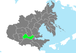
 Location of Changbaek Province in Zhenia. | |
| Country | Zhenia |
| Largest city | Handan |
| Elevation into Zhenian Province | December 8, 1909 |
| Capital | Yeongwon |
| Government | |
| • Governor | Baek Seoon (P) |
| Area | |
| • Total | 153,176.35 km2 (59,141.72 sq mi) |
| • Land | 150,281.32 km2 (58,023.94 sq mi) |
| • Water | 2,895.03 km2 (1,117.78 sq mi) 1.89% |
| • Rank | 15th |
| Population (2020) | |
| • Total | 12,581,698 |
| • Density | 82.1/km2 (213/sq mi) |
| Demonym | Changbaekian |
| Time zone | UTC+8 (ZEST) |
| Federal Postal Code | 28001-28999 |
| Provincial Code | CB |
Changbaek Province (Zhenian: 장백도) is a Zhenian province in the southern parts of Central Zhenia. Located near the Southern Han Mountains, it borders Jinhae and Imhae Province to the east, Balhae and Taehwa Provinces to the south and Jinwon Province to the west. Its capital is Yeongwon, while its largest city is Handan.

