Geography of Cadenza
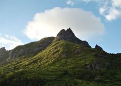
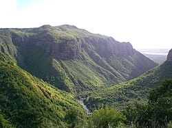
Cadenza is an island in western Astyria in the Sea of Jajich. Its main topographical features are a small central mountain range, with branches extending to the south and northwest coasts, ringed by fertile plains. Vekh Neramë, the highest peak on the island, is 1,163 m (3,816 ft) above sea level. The west coast is relatively rugged, particularly when compared to the south and east coasts, with several small headlands and bays. Of the four main rivers draining Cadenza, the longest is the Temloth which flows 40 kilometres (25 mi) from its source in the Tamari Valley to where it enters the sea below the city of Cadenza.
The island of Cadenza falls entirely under the jurisdiction of the state of Cadenza, as do the smaller islands around it, together forming an archipelago called the Eth Khadeg. It is located to the west of the island of Kur'zhet, which lies as close as 42.5 kilometres (26.4 mi) away; smaller islands of the two states come as close as 21.5 kilometres (13.4 mi) apart. The Cadenzan state has a total land area of 5,183.94 square kilometres (2,001.53 sq mi).
Geological development
Mountains

The mountains of Cadenza have all been formed by volcanic activity, a result of the island's passage over a hotspot under the Jajexan Plate. The primary range is formed from a granite batholith permeated by now empty lava tubes. Its six main peaks form a chain, running from the north-northeast and bending south. The highest peak is Vekh Neramë, at 1,163 m (3,816 ft) above sea level. Smaller hills, also volcanic, form an arc, around and to the east of the main mountain range, which includes both the southern island chain and the eastern islands.
Rivers and lakes
Cadenza's longest river is the Temloth, at 40 kilometres (25 mi), which flows east from its source in the Tamari Valley to the sea in a broad estuary below the city of Cadenza. Together with the Karea, which flows west from a source four kilometres away from the spring of the Temloth, it effectively divides the island into north and south. The Karea reaches the sea below Lema. The other major rivers are the Berak, which has its mouth in the city of Emigar, and the Osia which flows through Ro'ekha.
The largest body of standing water in Cadenza is a crater lake on Vekh Lamanë, formed by rainwater in the caldera of one of the island's many extinct volcanoes. The lake measures 4.8 square kilometres (1.9 sq mi) and is, at its deepest, 63 metres (207 ft). It has no outflow, but has been experiencing a net loss in water every year since 1997 as a result of evaporation. The lake includes a small island measuring 16 hectares (40 acres), a spur of a ridge which runs halfway out into the lake.
Islands and headlands
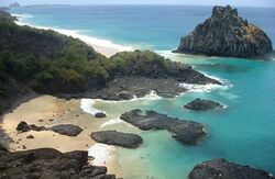
The main island of the Cadenzan archipelago, or the Eth Khadeg, is Khade, from which both the state and archipelago draw their names. Khade is surrounded by eight smaller islands, the largest and most northerly of which is Edarak, at 102 square kilometres (39 sq mi). Clockwise from Edarak, the other islands are Janari, Morza, Txisto, Askarz, Thananë, Urvaan and Ri'ezhen. Of these, only Edarak and Morza are permanently settled. Most of the remaining islands have been declared wildlife sanctuaries, especially for birds, such as that on the island of Janari.
Cadenza features many other islets, mostly little larger than rocks, but there are numerous headlands. Practically, these headlands are not particularly prominent in relation to the surrounding coast, the largest being Tarsira, north of Lema, which was formed a granite intrusion underneath the dominant limestone.
Climate
Cadenza experiences an equatorial tropical rainforest climate, narrowly avoiding the monsoon rains that affect most of Trellin's coastline on the Sea of Jajich. The weather station at the Port of Cadenza records an average of 1,450 mm (57 in) annually, compared to the empire's average of roughly 1,200 mm (47 in) but only half that which is recorded at Martheqa.
The prevailing winds are west-northwesterly, but a strong southeasterly air stream from mainland Trellin generally disrupts this current before it reaches Cadenza and protects the island from most major storms. Nevertheless, hurricanes occasionally sweep the northern coast, and in 2008 severe weather caused substantial damage to Ro'ekha and Canve.
Cadenza receives very little temperature variation during the course of the year, with an annual average range of just 6 degrees Celsius. The average highs vary by only 4 degrees, while the lowest temperatures tend to be from June to August. This situation has been brought about by Cadenza's equatorial position and the almost constant ocean temperatures around it. This extreme climatic stability has also led to a flourishing marine ecosystem and abundant coral reefs surrounding the archipelago.
| Climate data for Port of Cadenza | |||||||||||||
|---|---|---|---|---|---|---|---|---|---|---|---|---|---|
| Month | Jan | Feb | Mar | Apr | May | Jun | Jul | Aug | Sep | Oct | Nov | Dec | Year |
| Record high °C (°F) | 40.1 (104.2) |
38.3 (100.9) |
36.2 (97.2) |
37.5 (99.5) |
36.9 (98.4) |
38.4 (101.1) |
36.5 (97.7) |
39.7 (103.5) |
37.6 (99.7) |
39.2 (102.6) |
39.8 (103.6) |
41.7 (107.1) |
41.7 (107.1) |
| Average high °C (°F) | 32.3 (90.1) |
32.1 (89.8) |
31.2 (88.2) |
30.8 (87.4) |
29.9 (85.8) |
30.2 (86.4) |
29.3 (84.7) |
30.3 (86.5) |
30.4 (86.7) |
30.9 (87.6) |
33.4 (92.1) |
31.7 (89.1) |
33.4 (92.1) |
| Average low °C (°F) | 30.1 (86.2) |
29.8 (85.6) |
29.6 (85.3) |
29.2 (84.6) |
27.9 (82.2) |
27.4 (81.3) |
27.3 (81.1) |
27.4 (81.3) |
28.1 (82.6) |
28.8 (83.8) |
29.5 (85.1) |
30.3 (86.5) |
27.3 (81.1) |
| Record low °C (°F) | 23.4 (74.1) |
24.6 (76.3) |
22.7 (72.9) |
23.1 (73.6) |
19.3 (66.7) |
20.9 (69.6) |
23.8 (74.8) |
22.1 (71.8) |
20.4 (68.7) |
22.3 (72.1) |
21.5 (70.7) |
24.9 (76.8) |
19.3 (66.7) |
| Average precipitation mm (inches) | 93 (3.7) |
58 (2.3) |
45 (1.8) |
41 (1.6) |
54 (2.1) |
76 (3.0) |
154 (6.1) |
160 (6.3) |
184 (7.2) |
239 (9.4) |
216 (8.5) |
133 (5.2) |
1,453 (57.2) |
| Mean monthly sunshine hours | 122.6 | 164.3 | 179.1 | 168.7 | 205.2 | 217.4 | 185.0 | 130.6 | 107.3 | 95.1 | 114.8 | 135.2 | 1,825.3 |


