Geography of Trellin
The Trellinese Empire is a large country in western Teudallum comprising four nations: Trellin, Hysera, the Isles of Velar and Txekrikar. Its dominions straddle both the Equator and the Sea of Velar and enc
Geological development
The oldest known Trellinese rock was found in the western Ternosi desert and has been dated to 1.3 billion years ago. It is a remnant of a granite batholith from the Sarmisia craton, which broke up around 800-700 million years ago and is now part of the Jajexan plate. The Jajexan plate collided with the Tenedian plate around 450 million years ago, and the Tenedian Orogeny formed two parallel mountain belts whose lines roughly correspond to the current northwest Trellinese and northeast Jajexan Peninsular coasts.
At this point, 400 about million years ago, Trellin's north and south landmasses were in three separate parts: the Jajexan plate (which would later form southern Trellin and northern Trellin's westernmost reaches) lay east of modern Bankampar; the Parthenopean plate (now part of the Teudallic plate and forming eastern Trellin) was west of Symphonia, transiting westward along the Equator; and Arithemla, then on the Mederano plate, was near the Arctic Circle.
Mountains
Many of Trellin's borders are delineated by mountain ranges, including the Toron Kimruin on the Nahua border and the Vekra Retiqa which forms in part the border with Étlaurlande. These ranges were formed by crustal folding in three separate orogenies. The Toron Kimruin, with their highest peaks about 2,800 metres, are roughly 110 million years old. The Vekra Retiqa are 80-45 million years old, formed by the collisions of the Jajexan, Parthenopean and Mederano plates, and continue to grow at a rate of 1-3 cm per year. The highest peaks in this range are upwards of 4,500 metres. The Vekra Retiqa extends in an arc around the Great Bay of Arimathea from northwest Emla into Étlaurlande. Its southern arms reach into western Saheri and along the Kylarnatian border in Sycoon.
The northwest Vekra Retiqa were formed by the Lasaran Orogeny, a period of convergent tectonic activity between the Mederano and Jajexan plates which began during the Albian, 110 million years ago. The southward movement of the Mederano plate caused it to ride over the Jajexan plate, leading to orogenesis as granite in the latter pushed up under the southern Mederano plate. The current northwest Emlan coastline, defined by steep granite cliffs, is a product of this period. Arithemla, the region including modern Arimathea and Emla, became separated from the Mederano plate and is estimated to have attached to the Jajexan at this time.
The hills of eastern Trellin, along the Dangish border, as well as the Kur'malan Highland plateau, were created by the convergence of the Parthenopean and Teudallic plates, 30 million years ago in a brief period of localised tectonic activity. This upland region generally follows a southwest-northeast trend line but incorporates a major arm extending westward into the Vekra Retiqa from northern Kur'mala. The Kur'malan plateau, rising to 400 metres, fills the angle between these two arms. The Parthenopean now comprises the western portion of the Teudallic plate.
Volcanoes
Trellin has a number of active volcanoes, including several in the Sea of Velar. As the Jajexan plate passes westward over a hotspot, it has led to the creation of the islands of Cadenza and Kur'zhet. At present, it is responsible for the volcanicity of the Vekra Yarsali, a mountain chain in western Azmir including the active volcanoes Kaië Ryio'qi and Vekh Torsalë, and other volcanoes across Azmir and Mevirin.
Significant mountain ranges
- Vekra Retiqa — cordillera that dominates much of northern Trellin, comprising numerous major mountain ranges:
- Like this one
- Prosperity Hills — mountain range in southwest Rezat
Rivers and lakes
Many rivers drain the Trellinese landscape, even in the desert of the south and on the Kur'malan plateau. The four longest rivers are all in the north. Of these, the largest is the Serëtanz, both by overall length (at 810 kilometres) and by volume discharged, which flows from central Retikh to the Sea of Jajich at Tanzigar. The second longest, at 802 km, is the Flotir of central Trellin, followed by the Kaedroth of Lekhmir and Arimathea (596 km) and the Hanoth in Namija (482 km). The fifth longest river is the Etsakha, which flows from Khatax to enter the sea in north-central Rezat.
Other major river systems include the Ruhükyar, which together with its lakes Timenava and Uzarnet forms the Azmiri border with Khatax and Mevirin, the Baira which flows through the Usmalím, and the Emlan Lasara, which enters the sea with a 150 metre drop over a sheer cliff-face. Like the Ruhükyar, several rivers in Trellin possess major lakes. The Hanoth's Lake Revuniq covers 281 sq. km during the dry season, making it the second largest lake in Trellin behind Lake Tecihqa, on the Serëtanz, formed behind the narrow I'pethë canyon. With the exception of the four main systems, the rivers in the south are generally longer than those in the north but with fewer tributaries and a much smaller long-term average flow.
Several of Trellin's rivers have extensive deltas where they enter the sea. The largest river deltas are, in order, those of the Flotir, the Hanoth and the Serëtanz. The former two benefit from the relative shelter of the Sea of Velar, while the more destructive waves of the Sea of Jajich quickly erode new sediments deposited at the fringes of the broad Serëtanz delta.
Islands and peninsulae
Trellin has one of the most extensive coastlines in Astyria, amplified by its numerous islands and occasionally rugged coastlines with numerous bays, headlands and inlets. The largest peninsulae are the Jajexan Peninsula, Cape of Khem, Arnyü's Finger and [Briedh headland], all in the south. Emla and the Idisamoan Plateau are also sometimes regarded as peninsulae. Numerous lesser capes and headlands make up the empire's coastline: the Great Bay of Arimathea is enclosed by the Malahér and north Emlan capes, and the cities of Hyser and Rusetik stand on two of the larger promontories into the Sea of Jajich. Innumerable headlands ring the Sea of Velar.
Geographical regions
Climate

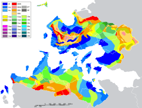
Because of its diverse topography and location, Trellin can be divided into a large number of distinct climatic regions, many of which are very small and varied. The predominant climate type is tropical, covering over 40% of the empire's land area. This can be subdivided into tropical monsoon, rainforest and savanna climates. The monsoon regions are predominantly along the Jajexan coast: from Mevirin to Emla, and around the Great Bay of Emla, as well as a corridor southeastward through the Sea of Velar. These areas are subject to seasonally torrential rains, and intense tropical storms affect most regions within 100 kilometres of the coast from March/April to mid-October with a high degree of predictability. The capital, Martheqa, receives an average of 2,870 mm of rainfall annually, compared to a national average of roughly 1,200 mm. Hurricanes are not uncommon on the northern coast of Trellin, and the coasts of the Great Bay often take severe damage from strong storms. Azmir and Mevirin experiences tropical storms as well, and these have been known to hit northern Cadenza and Kur'zhet on occasion.

Particularly in northern Trellin, large parts of the country are under rainforest, even in regions classified as tropical monsoon and humid subtropical. These rainforests extend throughout western Trellin and into central Retikh, in addition to covering most of Namija, southern Arimathea and large portions of the southern coast of the Sea of Velar. Up to 400,000 km2 of the empire's landmass is classed as tropical savanna, regions of comparative dryness behind the coastal regions. Particularly in the southern provinces, this ranges towards various semi-arid climates in Khatax and west Ternos. Regions of Khatax are considered dry desert under the Köppen climate classification system, though the majority is grass or scrubland.
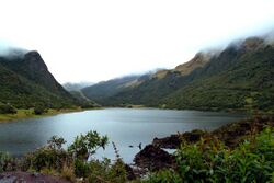
Several of Trellin's mountain ranges, such as the Vekra Retiqa and the Vekra Yarsali experience subtropical highland climates, as do the ranges on the Dangish border. On the empire's northern border with Sycoon, some peaks of the Vekra Retiqa have been known to remain snow-clad year-round, and a small region in the west-central Vekra Retiqa is regarded as Alpine tundra.
Flora and fauna
Trellin has a diverse wildlife as a result of its disparate climatic and topographical regions. Its multiplicity of biomes include some of the most ecologically significant regions in Astyria; the Tambodi and Namijan rainforests contains more unique species per square kilometre than almost any other biome in Teudallum, and reefs in the Seas of Jajich and Velar support thousands of marine species. The habitats of some native species have been threatened by urban sprawl in recent decades, but the empire's various habitats generally remain stable in both size and population.
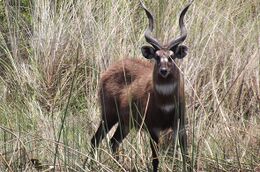
Terrestrial species endemic to Trellin include large mammals such as the Qeqsaraken antelope and the Tambodi tiger, as well as birds such as the blood thrush and Cadenzan woodpecker and invertebrates such as the giant Semerian millipede. Other species migrate to Trellin, from north and south, to winter in its warmer, equatorial climes. Some non-indigenous species have also been introduced to Trellin as permanent residents, of which the most iconic is the tasarin flower, brought en masse with the Ethlorek migrations and introduced to Arimathea in the fourth century BC.
Mammals
There are numerous indigenous mammals in Trellin, of which the largest is the MaybeAn Elephant. The largest predator is the Tambodi tiger, mostly constrained to the Tambodi rainforest but with a colony in Namija, followed by the Rezati leopard which is found across the south. There are also numerous herd animals, mostly found in the south and east of the empire where there are broad plains or grasslands. These include the Qeqsaraken antelope and Kuramalan antelope, as well as the lake buffalo of Azmir.
Smaller mammals include X
Birds and reptiles

Insects
Natural resources
Trellin's natural resources include large timber stock in its extensive rainforests, modest oil reserves in fields such as the Jatxesusna Deposits, substantial deposits of silver and diamonds including carbonado, hydropower and nutrient-rich marine waters.


