Ouestorlande: Difference between revisions
(Created page with "{{Infobox settlement | name = Ouestorlande | native_name = | native_name_lang = | settlement_type = List of Commonwe...") |
No edit summary |
||
| (2 intermediate revisions by the same user not shown) | |||
| Line 4: | Line 4: | ||
| native_name_lang = | | native_name_lang = | ||
| settlement_type = [[List of Commonwealths of Gagium|Commonwealth]] | | settlement_type = [[List of Commonwealths of Gagium|Commonwealth]] | ||
| image_skyline = | | image_skyline = Tmp6r8vmth_.png | ||
| image_alt = | | image_alt = | ||
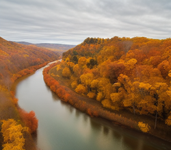
| image_caption = | | image_caption = Photograph of the [[Vergue River]] within Ouestorlande. | ||
| image_flag = Flag ouestorlande.png | | image_flag = Flag ouestorlande.png | ||
| flag_alt = Flag of Ouestorlande | | flag_alt = Flag of Ouestorlande | ||
| Line 96: | Line 96: | ||
}} | }} | ||
'''Ouestorlande''' is a [[List of Commonwealths of Gagium|commonwealth]] of [[Gagium]]. | '''Ouestorlande''' is a [[List of Commonwealths of Gagium|commonwealth]] of [[Gagium]] and a part of the [[Eastern Corridor (Gagium)|Eastern Corridor]] region. Ouestorlande is the TBDth largest commonwealth by land area and the 4th largest by population. Gagium's second largest city, [[Agen]], is the capital and largest city of Ouestorlande, with a metropolitan population of over 3 million. The [[Etrine River]] divides the commonwealth in half. Ouestorlande borders the commonwealths of [[Abagail]] to the southeast, [[Mayres]] to the south, [[Gourel]] to the southwest, [[Valmenier]] to the west, [[Mermarie]] and [[Poissac]] to the north, [[Langres]] to the northeast via Lake TBD, and [[Suntone]] and [[Rachelia]] to the east. Because of its central location within both the Eastern Corridor and the entire nation, Ouestorlande is nicknamed the "Crossroads of Gagium". | ||
| Line 103: | Line 103: | ||
[[Category:Manala]] | [[Category:Manala]] | ||
[[Category:Gagium]] | [[Category:Gagium]] | ||
[[Category:Commonwealths of Gagium]] | |||
Latest revision as of 18:01, 12 January 2023
Ouestorlande | |
|---|---|
 Photograph of the Vergue River within Ouestorlande. | |
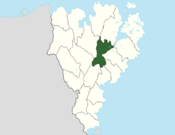
 Location of Ouestorlande within Gagium | |
| Country | Gagium |
| Capital and largest city | Agen |
| Declaration of Commonwealth | July 1301 |
| Government | |
| • Governor | Eliott Riviere (Rally for Social Democracy) |
| Area | |
| • Total | 109,786 km2 (42,389 sq mi) |
| Population (2020) | |
| • Total | 10,214,060 |
| Demonym | Ouestor |
| Area code | OU |
Ouestorlande is a commonwealth of Gagium and a part of the Eastern Corridor region. Ouestorlande is the TBDth largest commonwealth by land area and the 4th largest by population. Gagium's second largest city, Agen, is the capital and largest city of Ouestorlande, with a metropolitan population of over 3 million. The Etrine River divides the commonwealth in half. Ouestorlande borders the commonwealths of Abagail to the southeast, Mayres to the south, Gourel to the southwest, Valmenier to the west, Mermarie and Poissac to the north, Langres to the northeast via Lake TBD, and Suntone and Rachelia to the east. Because of its central location within both the Eastern Corridor and the entire nation, Ouestorlande is nicknamed the "Crossroads of Gagium".

