Antarctic Circle States
This article is incomplete because it is pending further input from participants, or it is a work-in-progress by one author. Please comment on this article's talk page to share your input, comments and questions. Note: To contribute to this article, you may need to seek help from the author(s) of this page. |
The Commonwealth of Antarctic Circle States | |
|---|---|
| Motto: "Research and Discovery" | |
| Anthem: "The Frozen Heartlands" National march: "Highland Cathedral" | |
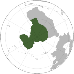
 Location of A.C.S. | |
| Capital | Erebus |
| Largest | Rothera |
| Official languages | Niagaran |
| Ethnic groups (2020) | |
| Religion (2020) |
|
| Demonym(s) | Antarctican |
| Government | Federal Presidential Parliamentary Republic |
| David C. Freeman | |
| Richard G. Dalton | |
| Legislature | Parliament |
| National Council | |
| National Assembly | |
| Independence from Greater Niagara | |
• Establishment | 27 November 1893 |
• Dominion | 14 December 1911 |
• Partition | 1 December 1983 |
| Area | |
• Total | 14,300,000 km2 (5,500,000 sq mi) |
• Water (%) | 2% |
| Population | |
• 2022 estimate | 11,081,235 |
• 2020 census | 11,076,461 |
• Density | 0.77/km2 (2.0/sq mi) |
| GDP (PPP) | 2022 estimate |
• Total | $876.3 billion |
• Per capita | $79,112 |
| GDP (nominal) | 2022 estimate |
• Total | $729 billion |
• Per capita | $65,815 |
| Gini (2022) | medium |
| HDI (2022) | very high |
| Currency | Antarctican Dollar (Å) (AQD) |
| Time zone | UTC+0 |
| Date format | dd/mm/yyyy yyyy-mm-dd |
| Driving side | right |
| Calling code | +42 |
| ISO 3166 code | AQ |
| Internet TLD | .aq |
Commonwealth of Antarctic Circle States (A.C.S. or ACS), commonly known as Antarctica, is a sovereign country comprising the mainland of the Frigo continent, the territory of Keeling Islands and numerous smaller islands. With an area of 14,300,000 square kilometres (5,500,000 sq mi), A.C.S. is the largest country by area in Frigo and the world's TBD-largest country. A.C.S. is the coldest, windest, and driest inhabited nation, with the least fertile soils. A.C.S. has the highest average elevation and contains the geographic South Pole. It also holds the record for the lowest measured temperature on Earth, −89.2 °C (−128.6 °F). The coastal regions can reach temperatures over 10 °C (50 °F) in summer.

