Mantocia: Difference between revisions
Jump to navigation
Jump to search
No edit summary |
No edit summary |
||
| Line 50: | Line 50: | ||
|established_event2 = TBDEVENT2 | |established_event2 = TBDEVENT2 | ||
|established_date2 = TBDDATE2 | |established_date2 = TBDDATE2 | ||
|established_event3 = | |established_event3 = Independence from [[León Monarchy]] | ||
|established_date3 = | |established_date3 = 2 June 1857 | ||
|area_km2 = 139303 | |area_km2 = 139303 | ||
|percent_water = | |percent_water = | ||
| Line 95: | Line 95: | ||
|cctld = .mn | |cctld = .mn | ||
|iso3166code = MN | |iso3166code = MN | ||
|calling_code = | |calling_code = +270 | ||
}} | }} | ||
'''Mantocia''', officially the '''Mantocian Republic''' (Mantocian: la '''Repubblica Mantociana'''), is a {{wp|country}} located in [[Stratea]] | '''Mantocia''', officially the '''Mantocian Republic''' (Mantocian: la '''Repubblica Mantociana'''), is a {{wp|country}} located in the [[Gulf of Atily (region)|Gulf of Atily]] region of [[Stratea]], covering an area of {{convert|139303|km2|abbr=on}} with a population of roughly 13.4 million. Mantocia shares land borders with [[Lurona]] and [[Luxchqiri]] to the southwest, [[Aghankir]] to the west, [[Mezia]] to the northwest, [[Lotia]] to the north, [[Tresula]] to the east (via the [[Tenific Ocean]]), and [[Tarran]] to the south (via the [[Gulf of Atily]]). The nation western portion of the country marks the beginning of the <!--"far rocks"-->[[Roclontane Mountains]], the longest and most prominent mountain range in Stratea. The highest point in Mantocia, [[Mount Passinius]], sits at almost 6,800 meters in elevation. | ||
== History == | |||
== Geography == | |||
== Politics == | |||
== Economy == | |||
== Demographics == | |||
== Culture == | |||
== See also == | |||
* [[Gulf of Atily (region)]] | |||
{{Manala topics}} | {{Manala topics}} | ||
Revision as of 16:22, 14 September 2023
Mantocian Republic Repubblica Mantociana | |
|---|---|
|
Flag | |
| Motto: TBD | |
| Anthem: | |
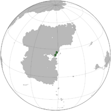
 Location of Mantocia in Stratea | |
| Location | Gulf of Atily region of Stratea |
| Capital and largest city | Rosella |
| Official languages | Mantocian, Caputian |
| Recognised national languages | Mantocian, Caputian, |
| Recognised regional languages | Lux |
| Ethnic groups | By race:
|
| Religion |
|
| Demonym(s) | Mantocian |
| Government | Unitary Bicameral Parliamentary Republic |
• President | Auro Rusco |
• Prime Minister | Bruno Leonetti |
• President of the Senate | TBD |
• President of the Chamber | TBD |
| Legislature | Parliament |
| Mantocian Senate | |
| Chamber of Representatives | |
| Establishment | |
• TBDEVENT1 | TBDDATE1 |
• TBDEVENT2 | TBDDATE2 |
• Independence from León Monarchy | 2 June 1857 |
| Area | |
• | 139,303 km2 (53,785 sq mi) |
| Population | |
• 2022 estimate | |
• 2020 census | 13,108,000 |
• Density | 96.4/km2 (249.7/sq mi) |
| GDP (PPP) | estimate |
• Total | ₭235.29 billion |
• Per capita | ₭17,950 (TBD) |
| HDI (2018) | very high |
| Currency | Mantocian Florin (MNT) |
| Time zone | +TBD |
| Date format | dd-mm-yyyy |
| Driving side | right |
| Calling code | +270 |
| ISO 3166 code | MN |
| Internet TLD | .mn |
Mantocia, officially the Mantocian Republic (Mantocian: la Repubblica Mantociana), is a country located in the Gulf of Atily region of Stratea, covering an area of 139,303 km2 (53,785 sq mi) with a population of roughly 13.4 million. Mantocia shares land borders with Lurona and Luxchqiri to the southwest, Aghankir to the west, Mezia to the northwest, Lotia to the north, Tresula to the east (via the Tenific Ocean), and Tarran to the south (via the Gulf of Atily). The nation western portion of the country marks the beginning of the Roclontane Mountains, the longest and most prominent mountain range in Stratea. The highest point in Mantocia, Mount Passinius, sits at almost 6,800 meters in elevation.
History
Geography
Politics
Economy
Demographics
Culture
See also
