Akenye: Difference between revisions
No edit summary |
No edit summary |
||
| Line 30: | Line 30: | ||
| national_motto = | | national_motto = | ||
| national_anthem = ''Song of the People'' | | national_anthem = ''Song of the People'' | ||
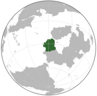
| image_map = | | image_map = [[File: Akenye Globe.png|200px]] | ||
| map_caption = | | map_caption = | ||
| image_map2 = | | image_map2 = | ||
Latest revision as of 04:38, 23 October 2023
Commonwealth of Akenye 4 official names
| |||||||||
|---|---|---|---|---|---|---|---|---|---|
| Anthem: Song of the People | |||||||||
 | |||||||||
| Capital | Ndiichieze | ||||||||
| Largest city | Ezulwini | ||||||||
| Ethnic groups (2023) |
| ||||||||
| Religion (2020) |
| ||||||||
| Demonym(s) | Akenyan | ||||||||
| Government | Unitary presidential republic | ||||||||
| Lwando Ndaba | |||||||||
| Sizwe Khumalo | |||||||||
| Zinzi Mbeki | |||||||||
| Nkosinathi Dlamini | |||||||||
| Legislature | Congress | ||||||||
| House of Faction | |||||||||
| House of Deputies | |||||||||
| Liberation from Alanna | |||||||||
• Colonial Rule | 1770 | ||||||||
• Autonomy | 1 July 1900 | ||||||||
• Declaration of Independence | 22 June 1938 | ||||||||
| 6 August 1942 | |||||||||
• Internal Autonomy | 12 February 1952 | ||||||||
| 6 August 1982 | |||||||||
| Area | |||||||||
• Total | 2,128,019 km2 (821,633 sq mi) | ||||||||
| Population | |||||||||
• 2023 estimate | 93,000,000 | ||||||||
• 2022 census | 92,239,019 | ||||||||
• Density | 43.7/km2 (113.2/sq mi) | ||||||||
| GDP (nominal) | 2023 estimate | ||||||||
• Total | |||||||||
• Per capita | |||||||||
| Gini (2023) | medium | ||||||||
| HDI (2022) | very high | ||||||||
| Currency | Akenyan Nwàlà (₦) | ||||||||
| Date format | dd-mm-yyyy | ||||||||
| Driving side | right | ||||||||
| Calling code | +95 | ||||||||
| ISO 3166 code | AK | ||||||||
| Internet TLD | .ak | ||||||||
Akenye, officially the Commonwealth of Akenye, is a country in western Galia. It is bordered to the east and north by the Great Galian Sea, to the west by the Depian Ocean, and to the south by Etesia. The country's climate is dry and arid, with predominant featuring of mild to cool, wet winters and hot, dry summers. This climate occurs mostly in the west of the country, including most major cities. The Amathol mountain range strongly affects the climate of the country, as areas to the west of the range are considerably drier than they would normally be. The mountainous terrain's rainshadow makes much of the northern part of the country dry and arid. Parts of the highlands are cooler and wetter, with snowfall being common along the east coast.
Over 92% of Akenyans are descended from Alannan ancestry, but about 15% of Alannan-descended Akenyans are descended from recent immigrants from Alanna or Alaoyi, and not Alannan colonists from the 18th and 19th centuries. The largest minority is a Gagian community of nearly 890,000 Gagians, primarily descended from Gagian traders and a unique dialect of the Gagian language is spoken by this minority. In addition, immigrants groups from Alaoyi, Etesia, and native groups are present in the country. Vanhish, Ikhetese, Ndibeanyan, and Gagian are official languages and the first language of 95.8% of the country and every Akenyan has the legal right to receive government services in one of those four languages. Within government, civil servants are required to be conversational in at least one language other than their native language and simultaneous translation is required for legislatures and town halls. Despite laws against discrimination, studies have found that individuals with a lingual background other than the main local language suffer from discrimination.
The area in what is now Akenye was sparesely populated due to a relatively harsh climate, with most Native Akenyans living around the Inkomati and Iqawe rivers. Alannan colonists arrived and forcibly removed the native population during the 1600s, with the Akenyan colonies being formally annexed in 1770 under Alannan-appointed governors. In 1900, the burgeoning yet rustic Akenyan colonies were granted local autonomy, ceding defense and foreign affairs to the Alannan government. In 1938, amid growing instability in Alanna, Akenye declared independence just a few days after Alaoyi did. Despite this brief era of independence, Akenye fell to an Inglaterran-Alannan invasion in 1941, surrendering in August. Akenye would be placed under Alannan control for almost ten years until internal autonomy was granted in 1952. Akenye would still be beholden to Alannan politics until 1982, when it was reestablished by Coalition forces. Under a new democratic government, Akenye's economy would grow as a part of the Liberation Miracle, or the rapid growth of the Akenyan and Onhsanenean economies in the 1980s-2000s.
Akenye is generally considered to be a more junior power in Galian affairs, with a strong economic and cultural presence, including the highest GDP per capita in the region. Akenye's military is relatively small but well trained and focused on defensive warfare from an invasion on the Etesian-Akenyan border. It is considered a high income economy and developed country with free and fair elections to determine government representatives and personal rights are respected. Most of the country's population lives in the south and west, especially along the Iqawe and Inkomati rivers. Akenye is a member of the Galian Entente, Global Community, and Galian Economic Conference. The country's capital and second largest city is Ndiichieze, with the largest city being Ezulwini. Other major cities include Enyioma, Nkonkobe, Amathole, Ithala, and Isibindi.
Politics
Main Article: Politics of Akenye
Government
Main Article: Government of Akenye
The central government is composed of three branches. The legislative branch consists of the bicameral Congress, made up of the House of Faction and the House of Deputies. The House of Deputies makes law, declares war, approves treaties and has the power of the purse and of impeachment, by which it can remove sitting members of the government. It represents the people and is elected by all voters aged 17 in up with mandatory voting in a first-past-the-post single member district election. In contrast, the House of Faction is elected through a proportional representation election and consists of 100 representatives. The House of Faction has curtailed powers. Its prime power is to elect the president, initiate impeachment proceedings, approve constitutional amendments, approve certain executive appointments, and ratify treaties. It can also veto presidential vetoes by a three fifths vote.

In the Executive branch, the President is the commander-in-chief of the military, can veto legislative bills before they become law—subject to Congressional override—and appoints the members of the Cabinet and other officers, who administer and enforce federal laws and policies. The President is elected by transferrable vote in the House of Faction. Each party votes via instant runoff voting, with the lowest ranked winner eliminated each round until a winner has a majority of votes. The president can be removed if three fifths of the House of Faction or two thirds of the House of Deputies removes the president. The House of Deputies is given priority over the House of Faction, meaning the House of Faction cannot reelect a president removed from office.
The Judicial branch includes the Supreme Court and lower courts that interpret laws and overturn those they find unconstitutional. The judiciary is independent of the executive and the legislative. To fill vacancies, a panel of judges elected by their peers, known as the Judicial Council. The president picks a candidate of their choice and the House of Faction must approve the candidate in the same method they elect the president. If either the president or the House of Faction rejects the chosen candidates, the process begins again. If the process repeats five times, the candidate will be chosen by the judiciary itself.


