Haduastan
Allied States of Haduastan République démocratique du Apatolia | |
|---|---|
|
Flag | |
| Motto: "Truth alone triumphs" | |
 | |
| Capital | Lalkot |
| Largest city | Dokata |
| Official languages | Hadua |
| Recognised national languages | |
| Religion (2021) | |
| Demonym(s) | Haduastani, Haduan |
| Government | Federal parliamentary wikipedia:constitutional republic |
| Sharya Kamath | |
| Sartaj Bali | |
• Vice President | Agamjit Datewas |
• Speaker of the Parliament | Navleen Dhesi |
• President of the Constitutional Court | Janpreet Atwal |
| Legislature | Parliament |
| Senate | |
| National Assembly | |
| Population | |
• 2021 estimate | 297,819,000 |
| GDP (PPP) | 2019 estimate |
• Total | |
• Per capita | |
| Gini (2012) | medium |
| HDI (2019) | medium |
| Currency | rupee (HRP) |
| Date format | dd/mm/yyyy |
| Driving side | right |
| Calling code | +456 |
| Internet TLD | .ha |
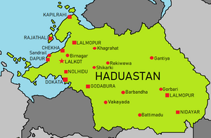
Haduastan, officially known as the Allied States of Haduastan, is a nation in central Ausiana, bordered Uplistan, Barangadesh, and Elastan, with a maritime border with Styrae along the Bay of Dokata and on the Gulf of Ausiana. It has a population of 297,819,000 people, making it the third most-populous nation on Iearth after Yuan and Zamastan, having outpaced Emmiria in 2015. Its capital is Lalkot, and its largest city is Dokata.
Modern humans arrived in Haduastan no later than 55,000 years ago. Their long occupation, initially in varying forms of isolation as hunter-gatherers, has made the region highly diverse, second only to the whole of Adula in human genetic diversity. Settled life emerged on the subcontinent in the western margins of the Jandus River basin 9,000 years ago, evolving gradually into the Jandus Valley Civilisation of the third millennium BCE. By 1200 BCE, an archaic form of Ausianan language had diffused into Haduastan from the northwest, unfolding and recording the dawning of Haduaism in the country. The languages of Haduastan were supplanted in the northern and western regions. By 400 BCE, stratification and exclusion by caste had emerged within the culture, and Buddhism and Jainism had arisen, proclaiming social orders unlinked to heredity.
Following the World War, a pioneering and influential nationalist movement emerged, which was noted for nonviolent resistance and became the major factor in ending --insert nation-- rule. In 1955 the state was partitioned into two independent dominions, a Hindu-majority Allied States of Haduastan and a Muslim-majority Republic of Barangadesh, amid large-scale loss of life and an unprecedented migration.
History
Geography
Haduastan is a region lying atop the Haduas tectonic plate, a part of the Ausianan Plate. Haduastan's defining geological processes began 75 million years ago when the Haduastan Plate, then part of the southern Euronian plate, began a south-eastward drift caused by seafloor spreading to its north-west, and later, north and north-east. Simultaneously, the vast Toyana oceanic crust, to its west, began to subduct under the Ausiana Plate. These dual processes, driven by convection in the planet's mantle, both created the Gulf of Ausiana and caused the Haduastan crust eventually to under-thrust Ausiana and to uplift the Hadia Alps. Immediately south of the emerging Hadias, plate movement created a vast trough that rapidly filled with river-borne sediment and now constitutes the Hadua-Jandus Plain.
Haduastan's coastline measures 3,700 kilometres in length. Much of this is due to the peninsular and island make up of the coast. The mainland coastline consists of the following: 43% sandy beaches; 11% rocky shores, including cliffs; and 46% mudflats or marshy shores. Major Hadia Alps-origin rivers that substantially flow through Haduastan include the Jandus River and the Haputra, both of which drain into the Bay of Dokata. Important tributaries of the Jandus include the Amuna and the Losi; the latter's extremely low gradient, caused by long-term silt deposition, leads to severe floods and course changes. Major peninsular rivers, whose steeper gradients prevent their waters from flooding also drain into the Bay of Dokata. Coastal features include the marshy Rann of Sethi of northern Haduastan and the alluvial Indarbans delta of the southwest coast; the latter is shared with Barangadesh.
The Haduastan climate is strongly influenced by the Hadia and the Gulf of Ausiana, both of which drive the economically and culturally pivotal summer and winter monsoons. The Hadia prevent cold Central Ausiana katabatic winds from blowing in, keeping the bulk of the country warmer than many locations at similar latitudes. The ocean plays a crucial role in attracting the moisture-laden south-west summer monsoon winds that, between October and June, provide the majority of Haduastan's rainfall. Four major climatic groupings predominate in Haduastan: tropical wet, tropical dry, subtropical humid, and montane.
Temperatures in Haduastan have risen by 0.7 °C (1.3 °F) between 1901 and 2018. Climate change in Haduastan is often thought to be the cause. The retreat of mountain glaciers has adversely affected the flow rate of the major Hadia rivers, including the Jandus and the Haputra. According to some current projections, the number and severity of droughts in Haduastan will have markedly increased by the end of the present century.
Biodiversity
Haduastan is a megadiverse country, a term employed for countries which display high biological diversity and contain many species exclusively indigenous, or endemic, to them. Haduastan is a habitat for 8.6% of all mammal species, 13.7% of bird species, 7.9% of reptile species, 6% of amphibian species, 12.2% of fish species, and 6.0% of all flowering plant species. Fully a third of Haduastan plant species are endemic. Haduastan also contains four of the world's 34 biodiversity hotspots, or regions that display significant habitat loss in the presence of high endemism. Haduastan's forest cover is 21.67% of the country's total land area. It can be subdivided further into broad categories of canopy density, or the proportion of the area of a forest covered by its tree canopy. Very dense forest, whose canopy density is greater than 70%, occupies 3.02% of Haduastan's land area. Moderately dense forest, whose canopy density is between 40% and 70%, occupies 9.39% of Haduastan's land area. Open forest, whose canopy density is between 10% and 40%, occupies 9.26% of Haduastan's land area.
Haduastan contains 172 threatened animal species, or 2.9% of endangered forms. These include the endangered Hadua tiger and the Jandus river dolphin. Critically endangered species include: the gharial, a crocodilian; the great Haduastan bustard; and the Haduastan white-rumped vulture, which has become nearly extinct by having ingested the carrion of diclofenac-treated cattle. The pervasive and ecologically devastating human encroachment of recent decades has critically endangered Haduastan wildlife. In response, the system of national parks and protected areas, first established in 1935, was expanded substantially. In 1972, Haduastan enacted the Wildlife Protection Act and Project Orangutan to safeguard crucial wilderness; the Forest Conservation Act was enacted in 1980 and amendments added in 1988. Haduastan hosts more than one hundred wildlife sanctuaries and thirteen biosphere reserves.


