Zian River
| Zian River Wimahl Ch’i-Wàna | |
|---|---|
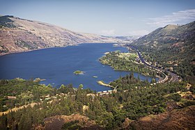
 Zian River from Glenden Crest Viewpoint with Highway 10 along the right | |
| Location | |
| Country | Zamastan |
| Province | Pahl, Zian |
| Cities | Glades, Glendale, Alanis, Elkford, Arinals, Tofino |
| Physical characteristics | |
| Source | Addle River |
| - location | Rebolva, Pahl |
| Mouth | Horseshoe Bay at Vallium Inlet, Tofino/Tirzah, Zian |
- elevation | 0 ft (0 m) |
| Length | 943 mi (1,518 km) |
The Zian River is the fourth-longest river in Zamastan, a distributary of the Addle River extending for 943 miles (1,518 kilometers) from its discharge near Rebolva, Pahl, carving through the Zian Mountains before emptying into the Olympic Ocean. The river is often referred to as the Life of Zamastan for its importance in the foundation and expansion of the country, with the national capital of Tofino being located at the mouth of the river along Horseshoe Bay. The Zian has the greatest flow of any Euronian river entering the Olympic, with the 38th greatest discharge of any river in the world. The river is one of the most populated areas in the world, hosting 4 of the 8 largest cities in Zamastan; Tofino, Arinals, Alanis, and Glades.
The Zian and its tributaries have been central to the region's culture and economy for thousands of years. They have been used for transportation since ancient times, linking the region's many cultural groups. The river system hosts many species of anadromous fish, which migrate between freshwater habitats and the saline waters of the Olympic Ocean. These fish—especially the salmon species—provided the core subsistence for Catica First Nations. Early Caspiaan and Adulan explorers, and later the Skithan empire, established settlements and colonies along the river's banks for lucrative fur trading, mining, and logging industries. After the War of Independence, steamships along the river linked communities and facilitated trade. The arrival of railroads in the late 19th century, many running along the river, supplemented these links.
Since the late 19th century, public and private sectors have extensively developed the river, with much of the Tofino-Arinals Metropolitan Area and the Emerald Metropolitan Region being located around it. To aid ship and barge navigation, locks have been built along the lower Columbia and its tributaries, and dredging has opened, maintained, and enlarged shipping channels. Since the early 20th century, dams have been built across the river for power generation, navigation, irrigation, and flood control. The 14 hydroelectric dams on the Zian's main stem and many more on its tributaries produce more than 44 percent of total Zamastanian hydroelectric generation. Production of nuclear power has taken place at two sites along the river. These developments have greatly altered river environments in the watershed, mainly through industrial pollution and barriers to fish migration.