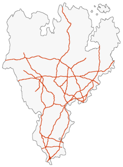
Gagian Expressway System
| Gagian Expressway System | |
|---|---|
  | |
| System information | |
| Maintained by Gagian Ministry of Infrastructure | |
| Formed | 1961 |
| Highway names | |
| Expressways | E-x - E-xxx |
| System links | |
| Routes Nationales of Gagium | |
The Gagian Expressway System is a network of approximately 36,000 km of controlled-access highways that serves as Gagium's national road network. Partially inspired by the national highway system of Hrvada, the Gagian Expressway System was signed into law by Prime Minister Benoit Bouchard on 15 April 1961. Originally designed solely to connect major Gagian population centers, the Expressway System has since evolved into an integrated highway system that connects both major cities and small towns and extends across all the commonwealths of Gagium. The size of the Expressway system was nearly doubled between 1983 and 2000, following the Third Great War.
The highways of the Gagian Expressway System, designated by the letter 'E', are both funded and maintained by the national government. Gagian Expressways all conform to specific standards, mainly the provision of two lanes in each direction that conform to specific lane and shoulder widths. The standards dictating the numbering of these highways call for all expressways to be designated with a one to three digit number. 1 and 2 digit expressways serve as main routes designed to connect different metropolitan areas to each other, while 3 digit expressways serve as routes meant to carry local traffic in a single metropolitan or geographical area. In addition to this, many of the highways of the Gagian Expressway System are operated as toll routes in order to support their maintenance as well as encourage other means of transportation, such as via the SCG's high speed railway network.
History
Standards
The current set of standards that Gagian Expressway System routes must conform to were established by the Ministry of Infrastructure in 1963. These standards were revised in 1974 and 1989 respectively, and are, as of May 2023:
- Controlled access: All access onto and off the highway is to be controlled with interchanges and grade separations, including all railroad crossings. In general, interchanges are spaced no closer than three kilometers apart. Furthermore, there are standards dictating the minimum distance of driveways or points of access along the crossroad of an entrance or exit ramp, as well as accomodating bike lanes.
- Minimum design speed: A minimum design speed of 120 km/h (75 mph) is to be used whenever possible. However, in urban and mountainous areas, a lower design speed of 80 or 90 km/h is often used, especially in cases of expressways near historic city centers.
- Minimum lane count and width: There are to be at least two lanes for general traffic in each directions, with an additional amount of lanes where necessary to accommodate an area's needs. Additionally, some expressways have additional lanes for bus traffic. The minimum lane width is 3.75 metres (12.3 ft).
- Shoulder width: The minimum width of the left paved shoulder is 1.25 metres (4.1 ft) and 3 metres (9.8 ft) for the right paved shoulder for a four-lane highway. However, in cases of three or more lanes in each direction, both shoulders should be at least 3 metres (9.8 ft) wide. However, shoulders may be more narrow or wide due to considerations such as the terrain or truck traffic.
- When deemed appropriate on a bridge, the width of both shoulders can be reduced to 1.25 metres (4.1 ft). Furthermore, reduced shoulder widths over historical bridges are allowed.
- Vertical clearance: The minimum vertical clearance under overhead structures, such as bridges, is 4.75 metres (15.6 ft), including both paved shoulders and an allowance for extra layers of pavement. Furthermore, highway signage and pedestrian overpasses must be at least half a meter higher than other objects (often 5.25 meters above the roadway).
There are no specific standards regarding the speed limit of an Expressway route. However, a speed limit of up to 130 km/h in rural areas and around 80 km/h in urban areas can be expected. Reduced speed limits can be a result of mountainous terrain, a necessary sharp turn, or urban infrastructure.

