Mantocia
Mantocian Republic Repubblica Mantociana | |
|---|---|
|
Flag | |
| Motto: TBD | |
| Anthem: | |
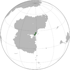
 Location of Mantocia in Stratea | |
| Location | Gulf of Atily region of Stratea |
| Capital and largest city | Rosella |
| Official languages | Mantocian, Caputian |
| Recognised national languages | Mantocian, Caputian, |
| Recognised regional languages | Lux |
| Ethnic groups | By race:
|
| Religion |
|
| Demonym(s) | Mantocian |
| Government | Unitary Bicameral Parliamentary Republic |
• President | Auro Rusco |
• Prime Minister | Bruno Leonetti |
• President of the Senate | TBD |
• President of the Chamber | TBD |
| Legislature | Parliament |
| Mantocian Senate | |
| Chamber of Representatives | |
| Establishment | |
• TBDEVENT1 | TBDDATE1 |
• TBDEVENT2 | TBDDATE2 |
• Independence from León Monarchy | 2 June 1857 |
| Area | |
• | 139,303 km2 (53,785 sq mi) |
| Population | |
• 2022 estimate | |
• 2020 census | 13,108,000 |
• Density | 96.4/km2 (249.7/sq mi) |
| GDP (PPP) | estimate |
• Total | ₭588.23 billion |
• Per capita | ₭44,875 (TBD) |
| HDI (2018) | very high |
| Currency | Mantocian Florin (MNT) |
| Time zone | +TBD |
| Date format | dd-mm-yyyy |
| Driving side | right |
| Calling code | +270 |
| ISO 3166 code | MN |
| Internet TLD | .mn |
Mantocia, officially the Mantocian Republic (Mantocian: la Repubblica Mantociana), is a country located in the Gulf of Atily region of Stratea, covering an area of 139,303 km2 (53,785 sq mi) with a population of roughly 13.4 million. Mantocia shares land borders with Lurona and Luxchqiri to the southwest, Aghankir to the west, Mezia to the northwest, Lotia to the north, Tresula to the east (via the Tenific Ocean), and Tarran to the south (via the Gulf of Atily). The western portion of the country marks the beginning of the Roclontane Mountains, the longest and most prominent mountain range in Stratea. The highest point in Mantocia, Mount Passinius, sits at almost 6,800 meters in elevation.
The Gulf of Atily region was historically home to several ancient indigenous groups, owing to its diverse climate of harsh deserts, arid mountains, and coastal savannas. The Mavonan Empire conquered contemporary Mantocia in 103 BCE during the reign of TBD, integrating the territory into the province of Atilia. The Mavonans are credited with founding the city of Rosella, the contemporary capital of Mantocia, in 54 BCE. During the split of the Mavonan Empire after the death of EMPERORTBD in 402, the province of Atilia fell under the rule of Upper Mavona. However, the Emperor of Upper Mavona based in TBDCITY was able to exert little influence over the region after the collapse of Middle Mavona in 483. Atilia, at the southern fringe of Upper Mavona, effectively fell out of Mavonan control by 600 as the Vigars, an ethnic group related to the modern-day Caputians and Ovist Caputians.
The Vigars were notorious raiders, sacking the city of Rosella after they conquered it and then establishing it as their base of operations. Beginning on the 8th century, the Vigars led raids reaching up to modern-day Pätschlàn. In 1094, the Vigar king Mantocio the Swordborn formed the Mantocian kingdom and converted to Benevianism. After Mantocio's death in 1103, Mantocia was briefly occupied by the Cagarian Dalamate; this occupation lasted until 1157 with the Siege of Bellanera. The renewed Mantocian kigndom held onto territory containing modern-day Mantocia as well as the majority-Caputian region of modern-day Lurona until the 14th century, when TBD of Caputia married King TBD of TOBECONTINUED
History
Geography
Politics
Economy
Demographics
Culture
See also
