Janolia
Republic of Janolia | |
|---|---|
| Anthem: Glory to a Brave People | |
 | |
| Capital and largest city | Azal |
| Official languages | An-Naas Semharan |
| Recognised regional languages | Onotenian |
| Ethnic groups (2022) | |
| Religion (2016) |
|
| Demonym(s) | Janolian |
| Government | Unitary presidential republic under a centralized authoritarian state |
| Kerez A'Maz | |
| Rashad Al-Tazz | |
| Legislature | Supreme National Assembly |
| Establishment | |
• Independence | 4 July 1985 |
| 4 July 1997 | |
| 12 January 1999 | |
| Area | |
• Total | 214,536 km2 (82,833 sq mi) |
| Population | |
• 2023 estimate | 1,200,000 |
• 2019 census | 1,102,937 |
• Density | 5.14/km2 (13.3/sq mi) |
| GDP (nominal) | 2022 estimate |
• Total | |
• Per capita | |
| Gini (2022) | medium |
| HDI (2022) | medium |
| Currency | Galian Shekel ($) Yawathan Yenaholi (¥) (both de facto) |
| Date format | dd-mm-yyyy |
| Driving side | right |
| Calling code | +964 |
| ISO 3166 code | JN |
| Internet TLD | .jn |
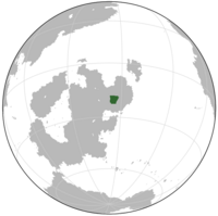
Janolia, officially the Republic of Janolia, is a country in north-central Galia. It is a unitary state under a presidential framework, with municipalities making up the primary administrative and local government in the country, but they are ultimately subservient to the central government. The country consists of about 1.2 million people covering 214,536 square kilometers. The landlocked state is bordered by Temelaeli and New Piedmont to the east, Balbaher to the north, Dumatina and Onotene to the west, and Louisiana to the south. The capital and largest city, with about half of the population, is Azal, in the south of the country. The rest of the population is primarily nomadic or rural, depending on oases and aquifers for water.
Like much of the territories in that part of Galia, what is now Janoli was independent for several centuries, primarily populated by nomadic desert-dwellers. These nomadic tribes would be absorbed into the Dilanoyawathan Empire as the province of Janolia. During the collapse of the Yawathan National Republic, the province of Janolia would go independent and establish a democratic government. In 1997, the government would be overthrown in a socialist coup after a disuted election. Much of the country is dry or semi-arid territory depending on oases and aquifers for water. This had made water consumption a major issue in the country. At 5.14 people per square kilometer, Janolia is one of the most sparesely populated countries in the world and is the most sparsely populated in the world.
Janolia is relatively underdeveloped, relying on agriculture and factories, leftovers of the Yawathan National Republic's industrialization programs, for its economy. It is limited by water access in the otherwise dry Galian interior. In the mid 2010, the excesses and poor policies of the incumbent government led to the collapse of the entire Janolian economy. The country struggles with record hyperinflation, shortages of basic goods, unemployment,[29] poverty, disease, high child mortality, malnutrition, severe crime and corruption. These factors have precipitated the Janolian refugee crisis where more than 50,000 people have fled the country. This crisis has led to the abolishing of Janolian-domestically printed currency in favor of foreign currencies, primarily the shekel or yenaholi. The country is a member of the Global Community and the Mutual Defense Pact.

