Hacyinia
This article is incomplete because it is pending further input from participants, or it is a work-in-progress by one author. Please comment on this article's talk page to share your input, comments and questions. Note: To contribute to this article, you may need to seek help from the author(s) of this page. |
The Union of Hacyinia | |
|---|---|
 Flag | |
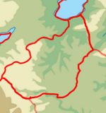
 Location of Hacyinia on Kylaris | |
| Capital and | Choch |
| Recognised national languages | Pardarian |
| Recognised regional languages | Syran: Gaullican, Ilkmen, Ziba Besshar: Beyek, Kacdag, Ukilen |
| Unrecognized regional languages | Chanwan |
| Ethnic groups | 45% Oroqic 48% Beyeks 52% Ilkmen 32% Pardarian 40% Kactag 60% Pasdewar 10% Chanwan 13% Other 46.5% Ukilen 38.5% Dezevauni 15% Other (Oeguns, others) |
| Religion | 45% Irfanic 40% Badi 6% Chanwan Folk Religion 5% Solarian Catholicism 2% Zohism 2% Other |
| Demonym(s) | Hacyinians |
| Government | Devolved unitary constitutional monarchy, with the parliament operating as a de facto one party government. |
• Khan | Makbule Arda Khan |
| Erasyl Rinat | |
| Legislature | Unified Assembly |
| Senate | |
| Legislative Chamber | |
| Establishment | |
• Orto Khanate | TBD |
• Syr Khanate | TBD |
• Khanate of Bessar established | 1790 |
• Syran independence | 1935 |
• Peoples Equalist Republic of Syran established | 1949 |
• Unification | 1994 |
| Area | |
• Total | 1,031,116.80 km2 (398,116.42 sq mi) (31st) |
| Population | |
• 2021 estimate | 37,000,000 (~ 37th) |
• Density | 35.88/km2 (92.9/sq mi) |
| GDP (PPP) | 2021 estimate |
• Total | $363.7 billion |
• Per capita | $9,831 |
| GDP (nominal) | 2021 estimate |
• Total | $80.86 billion |
• Per capita | $2,185.54 |
| Gini | 41.9 medium |
| HDI | 0.654 medium |
| Currency | Hacyinian Som (HSM) |
| Internet TLD | .ha |
Hacyinia, officially known as The Union of Hacyinia and also known as Basshar-Syran or Syran-Basshar, is a country in Coius. It borders Dezevau and Lavana to the east, Zorasan to the north and west, Shangea to the southwest, and Zomia to south. A landlocked country, it straddles the boundary between Southeast Coius and the Great Steppe physically and Greater Pardarian as well as Greater Southeast Coius culturally. The 31st largest country , Hacyinia occupies 1,031,116.80 km2. The physical landscape of the country is defined by mountainous terrian to the west, vast and sprawling steppe through much of the central area of the country, and fertile river deltas in the east along the shore of Lake Zinabad. The 37 million citizens are multi ethnic, multi lingual and multi religious, who can trace their heritage from the mosaic of nomadic and settled peoples that have influenced the countries history. Population-wise, Hacyinia is roughly the 37th most populous country in the world.
Most of Hacyinia's history has been as the vague borderlands of various larger, centralized powers nearby sans for a few gleaming city states along trade routes or recognized khanates in the steppes. The lands of Hacyinia have been conquered by various powers from near, far and homegrown. There had been little unity between the western and eastern regions of the modern country, sans occasionally being conquered by the same empire. The modern state of Hacyinia starts in the 18th and 19th century, when the Khanate of Besshar established itself in the westeran side of the country - an initially loose confederation of ungovernable steppe tribes and rebellious city states that secured de facto independence from a declining Aguda Empire. Besshar was recognized as an independent state and a Gaullican protectorate following the collapse of the Aguda Empire and incorporation of former Agudaian territories into the Gaullican colonial empire. Following the Great War, Syran gained independence. An unstable republic from the onset, beset by multiple influences in the chaotic post-war era, an Equalist coup overthrew the country establishing the Peoples Equalist Republic of Syran.
Hostilities and tension quickly arose between the two countries as they attempted to enforce their claim to the vast steppe space separating them. Border skirmishes and open conflict was common for years. It wasn't until the joint decline of both countries governments due to domestic issues that unification, brokered by international agreement, was reached and went into effect in 1994. The following 28 years has seen a dysfunctional government, partly led by former members of the Equalist Party of Syran and partly led by the Khan of Besshar, muddle through in an almost perpetual state of political crisis. The Hacyinia Troubles has only increased over the years and now it is commonly recognized by many observers, both domestic and internationally, that Hacyinia is on the brink of collapse. Besshar separatists have become more vocal and active in demanding a "two state solution", while the Syranian-led central government refuses to allow any succession to happen. Both factions with foreign backing have been more or less preparing openly for some sort of showdown that many estimate will be coming soon.
Etymology
Hacyinia comes from the Old Pardarian word "hamicyia", meaning rebellious. The descriptor of the steppe peoples eventually came to refer to the whole general steppe area south of Pardaran proper. The word didn't gain a political meaning until the mid 20th century when the first ideas of unification between Besshar and Syran were proposed. When Besshar and Syran did unify and merge into one state in 1994, the name Hacyinia was chosen as the new state name.
The names of the two competent states of Hacyinia, Besshar and Syran, are both Oroqic and Pardarian blended words. Besshar means "Five Cities" and Syran translates to the "Land of Syr/Sir". Besshar stems from the 18th and 19th centuries when the once fairly stateless region began to centralize around the oases city states nestled into the foothills of Mount Chanwan, forming a new polity in the face of the Aguda Empires slow collapse. Syran stems from a much earlier time, and is the result of the eponymous founder of the Syr Khanate in the 11th and 12th centuries. Although the Syr Khanate collapsed shortly after it's founding, the Aguda Empire adopted the local endonym of the province which then became widespread.
History
Hacyinia has a long history, dominated mostly by the nomadic peoples that have ruled from the steppes as well as powerful empires who have conquered and held sway over the area. Although the area has long been inhabited with archeological records showing evidence of human settlement dating back to 6,000 BCE; the first recorded peoples in the area date back to the second millennia B.C with !Scythian/!Saka nomads domaining the steppes and settled Pardardian speaking city states establishing themselves in the eastern river deltas by Lake Zinabad, as well as in the foothills of the western mountains. The Chanwan had long called the highlands of western Hacyinia home and began establishing their own polity's in the highlands of the Huashan mountain range. In the southwestern steppe, in the modern day borderlands between Hacyinia, Zomia and Lavana, the !Xiongnu/Proto-Beyeks held sway and competed with the !Scythians/!Saka for control of the steppe. The !Xiongnu were able to establish several of their own powerful states controlling parts of Southeast Coius until just before the end of the 1st century CE.
The almost simultaneous Badi Reaction and the expansion of the Second Heavenly Dominion
Following the Tagamic Migrations
The era of the Khanates
Aguda Empire, direct control in the east and suzerainty in the west,
Gaullican Syran
Indepdent Besshar
Independent Syran, then Peoples Equalist Republic
Conflicts/"two state period"
Decline of both states
Unification and The Troubles.
Geography
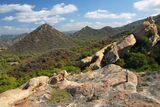
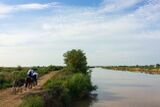
At 1,031,116.80 km2, Hacyinia is the 15th largest in Coius, and the 31st largest in the world. It is slightly smaller than Behera and slightly larger than Belmonte. A landlocked country, it has a minimally varied terrain. The country is overwhelmingly steppe land, with some geographic diversity in the west with the Transhuashan foothills and in the east riverine deltas in low valleys. The elevation of the country varies greatly however, with some areas being several thousand meters above sea levels and others being several hundred meters below sea levels. Generally elevation rises the in the west and closer to the Huashan mountains.
Arable land is at a minimum, with most of the water in the central steppes of the country coming from oases and seasonal rivers. The steppes soil is incapable of supporting any sort of large scale agriculture, although it is more than capable of supporting large scale animal husbandry both historically and modern day. The "steppe" of the country often interchanges between what is technically considered savanna, with much longer grasses, as well as true steppe with much shorter grasses.
Most of the countries arable land is concreated in the east along the shore of Lake Zinabad and the river deltas near the shore, or in the west in mountain oases supplied by the melting glacial water of the Huashan mountains. The country almost is entirely considered to be within a semi-arid climate zone, with warm summers and cold winters. Rainfall is dependent on the season, with the winter being typically much dryer than the summer. In addition, temperature swings can greatly vary from day and night.
Wildlife
Bactarian deer! Bactarian camels! Wolves! There's brown bears in Central Asia apparently? Snow lepords, cut & paste from stuff
Demographics
8,339,800 Beyeks 8,680,200 Ilkmen
4,107,000 Kacdags 6,993,000 Pasedwars
4,070,000 Chanwan
2,236,650 Ukilen 1,851,850 Dezenaui 721,500 Other
Besshar total: 15,044,200 Besshar including Chanwan: 19,114,200 Syran: 17,885,800
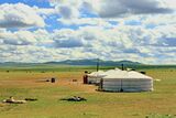
Population is actually suprinsingly dense and kinda urbanized? Since most of the population is on either the far western or the far eastern sides of the country, just a bunch of open space in the middle. Solid chunk of the population still practice nomadism.
Urbanization
cities: Besshar: Maymana Tuska* Kucha Tulean Osh
Syran: Choch ** Halac Satlyk Shirvan Babak
Government and Politics
damn this government isn't working. Royalists and Equalist just can't cooperate on basic issues, who knew?
Economy
think Mongolia/Kazakhstan/similar stuff. Oil producing = 1,229,357 barrels per day? I think a big thing with the economy is that is actually could be really powerful, but, with the domestic shitshow going on its unlikely to reach anything close to it's potential in any due time.
Culture
Culturally Besshar is more turko-mongol, Syran is more turko-persian. Heavy influence from SE Asia, I imagine national food sorta similar to the Uyghurs/Hazaras? You know we be making rugs. Besshar is Badist, Syran is Irfanic.
Sport
Rugby union is most popular team sport. og known as tülkhekh (mongolian)/sxojyn (oss)/ïterw (kaz) ["to push"]; Eucleans were like "damn I know a game like that" and introduced rugby to folks proper. Much more popular in the west, used as a piece of cultural/'civilizing' imperialism. Syran following the equalist revolution was like "nah we dont rugby anymore because it's bourgeoius af" and was more of the gymnastic socialist.
Kokpar also very popular, as well as other equestrian games/activities owing to countries steppe and horse culture. Mongolian wrestling/Turkic wrestling also popular. Something like Naadam very possible.