Talvistova: Difference between revisions
No edit summary |
|||
| (35 intermediate revisions by 3 users not shown) | |||
| Line 2: | Line 2: | ||
{{Infobox country | {{Infobox country | ||
|conventional_long_name = | |native_name = ''pyhä talvikuningas'' | ||
|image_flag = [[File: | |conventional_long_name = Kingdom of Talvistova | ||
|image_flag = [[File:Kingdom of Talvistova.png|frameless]] | |||
|national_motto = "For Religion, King, and Glory" | |national_motto = "For Religion, King, and Glory" | ||
|image_map = | |image_map = [[File:158186907595599049.png|200px]] | ||
|capital = Ljustad, Osta | |capital = Ljustad, Osta | ||
|largest_city = Skalgaard, Osta | |largest_city = Skalgaard, Osta | ||
|official_languages = | |official_languages = Talvistovan | ||
|national_languages = | |national_languages = German, Libriran | ||
|ethnic_groups = | |ethnic_groups = | ||
* | * 93% Caucasian | ||
* | * 2% Vuori | ||
* | * 5% other | ||
|demonym = Talvistovan | |demonym = Talvistovan | ||
|government_type = | |government_type = Hereditary Monarchy | ||
|leader_title1 = King | |leader_title1 = King | ||
|leader_name1 = | |leader_name1 = Oskar I | ||
|leader_title2 = | |leader_title2 = Heir Apparent | ||
|leader_name2 = | |leader_name2 = N/A | ||
|established_event1 = Independence from [[Engleberg|Englean Kaiserreich]] | |established_event1 = Independence from [[Engleberg|Englean Kaiserreich]] | ||
|established_date1 = 31 March | |established_date1 = 31 March 1566 | ||
|area = <!-- major area size (in [[Template:convert]] either km2 or sqmi first) --> | |area = <!-- major area size (in [[Template:convert]] either km2 or sqmi first) --> | ||
|area_km2 = | |area_km2 = 878,144 | ||
|area_sq_mi = <!-- area in square mi (requires area_km2) --> | |area_sq_mi = <!-- area in square mi (requires area_km2) --> | ||
|area_footnote = <!-- optional footnote for area --> | |area_footnote = <!-- optional footnote for area --> | ||
| Line 31: | Line 32: | ||
|area_dabodyalign = <!-- text after area_label2 (optional) --> | |area_dabodyalign = <!-- text after area_label2 (optional) --> | ||
|population_estimate_year = 2018 | |population_estimate_year = 2018 | ||
|population_estimate = | |population_estimate = 33,592,671 | ||
|population_census = | |population_census = | ||
|population_census_year = | |population_census_year = | ||
|population_density_km2 = | |population_density_km2 =15.89 | ||
|population_density_sq_mi = | |population_density_sq_mi = | ||
|population_density_rank = | |population_density_rank = | ||
| Line 42: | Line 43: | ||
|GDP_PPP_per_capita = | |GDP_PPP_per_capita = | ||
|GDP_PPP_per_capita_rank = | |GDP_PPP_per_capita_rank = | ||
|GDP_nominal = | |GDP_nominal = 90,322,886,438Ӄ | ||
|GDP_nominal_rank = | |GDP_nominal_rank = | ||
|GDP_nominal_year = 2018 | |GDP_nominal_year = 2018 | ||
|GDP_nominal_per_capita = 36,841 | |GDP_nominal_per_capita = 36,841 ӃPC | ||
|GDP_nominal_per_capita_rank = | |GDP_nominal_per_capita_rank = | ||
|Gini = | |Gini = | ||
| Line 57: | Line 58: | ||
|HDI_change = <!--increase--> | |HDI_change = <!--increase--> | ||
|HDI_category = | |HDI_category = | ||
|currency =Kronig ( | |currency =Kronig (Ӄ) | ||
|currency_code = | |currency_code = | ||
|time_zone =Kingstown Time | |time_zone =Kingstown Time | ||
| Line 79: | Line 80: | ||
}} | }} | ||
The ''' | The '''Kingdom of Talvistova''' ({{wp|Finnish|Talvistovan}}: ''pyhä talvikuningas'' [Lit. 'Holy Winter Kingdom']; Englean: 'Nordenreich' ), or simply Talvistova, is large nation in Northern [[Ventismar]] that borders the Northern Lutentian to the West and North, Strait of Good Faith to the south, Gulf of Paajarvi to the East, and [[Librira]] to the Northeast. The capital is the city-province of Ljustad, whereas the largest city is Skalgaard. Other major cities include Manavik, Asbjarnarstaoir, Lonlond, and Kvingandannes. | ||
As of the end of January 2018, the population if Talvistova is 33.6 million, most of which live in the southwestern part of the country and speak {{wp|Finnish|Talvistovan}}, a Nordic language unrelated to nearby German or Libirian Languages. It is a Heretical Monarchy made up of 22 provinces and one semi-autonomous city-province (Ljustad). The Majority of Talvistovans are a part of the {{wp|Eastern Orthodox Church}}. | |||
==History== | |||
===Prehistory=== | |||
If archaeological finds found in caves in the South Kainuu Mountains are in fact the work of Neanderthals, then the first human habitation of what is today Talvistova occurred somewhere between 180,000 and 145,000 BC, while the more northern regions such as the lapland and North Kainuu Mountains are generally believed to have been settled somewhere after 115,000 BC. The artifacts found in said areas carry strong resemblence to those found in [[North Rukonia]] and the [[Anglea|Englean Kaiserreich]], which has lead to a prevailing theory that at one point there was a land bridge that was used as a crossing point across the modern day Strait of Good Faith. Like most of the proto-ventismarin people, the stone age settlers where hunter-gatherers. | |||
The next major innovation that we have record of is pottery recently unearthed outside of Ljustad that is dated to approximately 6,100 Bc, which means that this is probably the time period that agriculture was introduced to Talistova. Although even with the advent of agriculture, it is still largely believed by many archaeologists that it was still very much a hunting and fishing civilization at this point in time. | |||
[[File:Kuusiston linna.jpg|thumb|200px|left|The ruins of Taivaan Kehto, 1999]] | |||
Around 2,000 BC, the Bronze age brought about year round cultivation as well as animal husbandry, but the cold and rugged climate of the central and northern regions slowed it's advance into the rest of the Country. Around 500 years later, the first major Talvistovan settlement was formed, this being the now abandoned city and world heritage site Taivaan Kehto, and from this city would spread the first notable power a little under 1000 years later, what is now known as the Proto-Talvic Empire. | |||
===Proto-Talvic Conquest=== | |||
For approximately the next 500 to 600 years, the Proto-Talvics where predominately focused on conquering the rest of what would Become Talvistova, and bring the several hundred disconnected tribes under one banner. There is some controversy as to how successful they are, as rune stones discovered in the modern Valley of Plenty have been deciphered to discuss "great victories in the north", whereas those found in the Lapland using a different alphabet mention a great victory against the invaders, although whether they are both propaganda is a hotly debated subject. What is unanimously agreed upon is that by the year 600AD, the campaigns began stalling somewhere around the northern mouth of the Gulf, in what is called "The great stumble" in some carvings from the era believed to be about the topic. It was around this time we also get an idea as to who was in charge around this point, that being the semi-historical King Hrathgar the Ancient, who played a massive part in the development of the two most respected castes in early talvic society, that being adventurers and cartographers, and the raiders and warriors. This era became known as the Talvic Golden Age. | |||
== | ===Talvic Golden Age=== | ||
[[File:Nicholas Roerich, Guests from Overseas.jpg|200px|thumb|right| An artist's rendering of a Talvic longship voyage]] | |||
The Talvic Golden Age is officially recognized as starting around the year of 662, when the first wave of Talvic sailors and map makers set out through the Strait of Good Faith to see and chart what lies beyond it. The most notable of which being a man named Egil Vendelcrow, who is credited as the first man to fully chart the coast of ventismar. It was at this point that raiders also began pillaging villages on the Northern Englean Coast, which would result in the beginning of the Englean-Talvic Wars. | |||
==Geography== | ==Geography== | ||
With the majority of the country lying just below the Arctic Circle, Talvistova is one of the northernmost countries in the World, second only to certain stretches of neighboring [[Librira]] lying farther north. As far as capitals, Ljustad is the northernmost capital in the world. | |||
Much of the Geography of Talvistova was formed as a result of the Convergence of the Talvo-Arctic Plates and the libririan plates, thus forming the Kainuu Mountains in the eastern half of the country. | |||
===Climate=== | ===Climate=== | ||
===Environment=== | ===Environment=== | ||
<small>''main article: [[Fauna of Talvistova]]''</small> | |||
==Politics and Government== | ==Politics and Government== | ||
| Line 120: | Line 138: | ||
====Sports==== | ====Sports==== | ||
{{ | {{Talvistova topics}} | ||
{{Sunalaya Topics}} | |||
[[Category:Sunalaya]] | |||
[[Category:Countries]] | |||
[[Category:Countries on Sunalaya]] | |||
[[Category:Talvistova]] | |||
[[Category:Orange-Class Sunalaya articles]] | |||
Latest revision as of 04:39, 23 August 2020
This article is incomplete because it is pending further input from participants, or it is a work-in-progress by one author. Please comment on this article's talk page to share your input, comments and questions. Note: To contribute to this article, you may need to seek help from the author(s) of this page. |
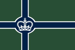
Kingdom of Talvistova pyhä talvikuningas | |
|---|---|
|
Flag | |
| Motto: "For Religion, King, and Glory" | |
 | |
| Capital | Ljustad, Osta |
| Largest city | Skalgaard, Osta |
| Official languages | Talvistovan |
| Recognised national languages | German, Libriran |
| Ethnic groups |
|
| Demonym(s) | Talvistovan |
| Government | Hereditary Monarchy |
• King | Oskar I |
• Heir Apparent | N/A |
| Establishment | |
• Independence from Englean Kaiserreich | 31 March 1566 |
| Area | |
• | 878,144 km2 (339,053 sq mi) |
| Population | |
• 2018 estimate | 33,592,671 |
• Density | 15.89/km2 (41.2/sq mi) |
| GDP (nominal) | 2018 estimate |
• Total | 90,322,886,438Ӄ |
• Per capita | 36,841 ӃPC |
| HDI (2018) | .825 very high |
| Currency | Kronig (Ӄ) |
| Time zone | UTC-6 (Kingstown Time) |
| Date format | mm-dd-yyyy |
| Driving side | right |
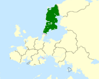
The Kingdom of Talvistova (Talvistovan: pyhä talvikuningas [Lit. 'Holy Winter Kingdom']; Englean: 'Nordenreich' ), or simply Talvistova, is large nation in Northern Ventismar that borders the Northern Lutentian to the West and North, Strait of Good Faith to the south, Gulf of Paajarvi to the East, and Librira to the Northeast. The capital is the city-province of Ljustad, whereas the largest city is Skalgaard. Other major cities include Manavik, Asbjarnarstaoir, Lonlond, and Kvingandannes.
As of the end of January 2018, the population if Talvistova is 33.6 million, most of which live in the southwestern part of the country and speak Talvistovan, a Nordic language unrelated to nearby German or Libirian Languages. It is a Heretical Monarchy made up of 22 provinces and one semi-autonomous city-province (Ljustad). The Majority of Talvistovans are a part of the Eastern Orthodox Church.
History
Prehistory
If archaeological finds found in caves in the South Kainuu Mountains are in fact the work of Neanderthals, then the first human habitation of what is today Talvistova occurred somewhere between 180,000 and 145,000 BC, while the more northern regions such as the lapland and North Kainuu Mountains are generally believed to have been settled somewhere after 115,000 BC. The artifacts found in said areas carry strong resemblence to those found in North Rukonia and the Englean Kaiserreich, which has lead to a prevailing theory that at one point there was a land bridge that was used as a crossing point across the modern day Strait of Good Faith. Like most of the proto-ventismarin people, the stone age settlers where hunter-gatherers.
The next major innovation that we have record of is pottery recently unearthed outside of Ljustad that is dated to approximately 6,100 Bc, which means that this is probably the time period that agriculture was introduced to Talistova. Although even with the advent of agriculture, it is still largely believed by many archaeologists that it was still very much a hunting and fishing civilization at this point in time.
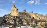
Around 2,000 BC, the Bronze age brought about year round cultivation as well as animal husbandry, but the cold and rugged climate of the central and northern regions slowed it's advance into the rest of the Country. Around 500 years later, the first major Talvistovan settlement was formed, this being the now abandoned city and world heritage site Taivaan Kehto, and from this city would spread the first notable power a little under 1000 years later, what is now known as the Proto-Talvic Empire.
Proto-Talvic Conquest
For approximately the next 500 to 600 years, the Proto-Talvics where predominately focused on conquering the rest of what would Become Talvistova, and bring the several hundred disconnected tribes under one banner. There is some controversy as to how successful they are, as rune stones discovered in the modern Valley of Plenty have been deciphered to discuss "great victories in the north", whereas those found in the Lapland using a different alphabet mention a great victory against the invaders, although whether they are both propaganda is a hotly debated subject. What is unanimously agreed upon is that by the year 600AD, the campaigns began stalling somewhere around the northern mouth of the Gulf, in what is called "The great stumble" in some carvings from the era believed to be about the topic. It was around this time we also get an idea as to who was in charge around this point, that being the semi-historical King Hrathgar the Ancient, who played a massive part in the development of the two most respected castes in early talvic society, that being adventurers and cartographers, and the raiders and warriors. This era became known as the Talvic Golden Age.
Talvic Golden Age
The Talvic Golden Age is officially recognized as starting around the year of 662, when the first wave of Talvic sailors and map makers set out through the Strait of Good Faith to see and chart what lies beyond it. The most notable of which being a man named Egil Vendelcrow, who is credited as the first man to fully chart the coast of ventismar. It was at this point that raiders also began pillaging villages on the Northern Englean Coast, which would result in the beginning of the Englean-Talvic Wars.
Geography
With the majority of the country lying just below the Arctic Circle, Talvistova is one of the northernmost countries in the World, second only to certain stretches of neighboring Librira lying farther north. As far as capitals, Ljustad is the northernmost capital in the world.
Much of the Geography of Talvistova was formed as a result of the Convergence of the Talvo-Arctic Plates and the libririan plates, thus forming the Kainuu Mountains in the eastern half of the country.
Climate
Environment
main article: Fauna of Talvistova


