Eth Bandig: Difference between revisions
mNo edit summary |
mNo edit summary |
||
| Line 3: | Line 3: | ||
{{Infobox islands | {{Infobox islands | ||
| name = Bandi Archipelago | | name = Bandi Archipelago | ||
| | | native_name = ''Eth Bandig'' | ||
| native name link = | | native name link = | ||
| sobriquet = | | sobriquet = | ||
| image | | image = Eth Bandig detail.png | ||
| | | image_size = 250px | ||
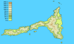
| | | image_caption = Topographic map of the Eth Bandig | ||
| image alt = | | image alt = | ||
| | | map_image = Eth Bandig orth.png | ||
| | | map_size = 250 px | ||
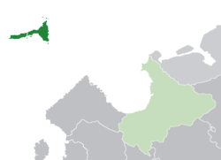
| | | map_caption = Location of the '''Eth Bandig''' (dark green) in Arimathea (light green) | ||
| location = [[Arimathea]]; [[Sea of Jajich]] and [[Mederano Sea]] | | location = [[Arimathea]]; [[Sea of Jajich]] and [[Mederano Sea]] | ||
| coordinates = | | coordinates = | ||
| archipelago = | | archipelago = | ||
| | | total_islands = 10 | ||
| | | major_islands = Torim Edros · Torim Kezidindri · Sia Theskimiri | ||
| | | area_km2 = 7680 | ||
| | | area_footnotes = | ||
| rank = | | rank = | ||
| | | length_km = <!-- or length m --> | ||
| length footnotes = | | length footnotes = | ||
| | | width_km = <!-- or width m --> | ||
| width footnotes = | | width footnotes = | ||
| | | coastline_km = 850.5 | ||
| coastline footnotes = | | coastline footnotes = | ||
| elevation m = | | elevation m = | ||
| Line 31: | Line 31: | ||
| highest mount = <!--name--> | | highest mount = <!--name--> | ||
| Country heading = | | Country heading = | ||
| country = Arimathea | | country = {{flag|Arimathea}} | ||
| | | country_admin_divisions_title = District | ||
| | | country_admin_divisions = Eth Bandig | ||
| country admin divisions title 1 = | | country admin divisions title 1 = | ||
| country admin divisions 1 = | | country admin divisions 1 = | ||
| country admin divisions title 2 = | | country admin divisions title 2 = | ||
| country admin divisions 2 = | | country admin divisions 2 = | ||
| | | country_capital = Khalet | ||
| | | country_largest_city = Azarë | ||
| | | country_largest_city_population = 64,914 | ||
| | | country_leader_title = Grand Duke | ||
| | | country_leader_name = Josev VII Belimos | ||
| country 1 = | | country 1 = | ||
| country 1 admin divisions title = | | country 1 admin divisions title = | ||
| Line 57: | Line 57: | ||
| demonym = Bandexan | | demonym = Bandexan | ||
| population = 371,692 | | population = 371,692 | ||
| | | population_as_of = 2013 | ||
| | | density_km2 = 48.4 | ||
| density footnotes = | | density footnotes = | ||
| | | ethnic_groups = 94.7% [[Trellinese people|Trellinese]]<br>5.3 % others | ||
| website = | | website = | ||
| additional info = | | additional info = | ||
Revision as of 21:58, 4 February 2019
This article is incomplete because it is pending further input from participants, or it is a work-in-progress by one author. Please comment on this article's talk page to share your input, comments and questions. Note: To contribute to this article, you may need to seek help from the author(s) of this page. |
| Native name: Eth Bandig | |
|---|---|
 Topographic map of the Eth Bandig | |
 Location of the Eth Bandig (dark green) in Arimathea (light green) | |
| Geography | |
| Location | Arimathea; Sea of Jajich and Mederano Sea |
| Total islands | 10 |
| Major islands | Torim Edros · Torim Kezidindri · Sia Theskimiri |
| Area | 7,680 km2 (2,970 sq mi) |
| Coastline | 850.5 km (528.48 mi) |
| Administration | |
| District | Eth Bandig |
| Capital city | Khalet |
| Largest settlement | Azarë (pop. 64,914) |
| Grand Duke | Josev VII Belimos |
| Demographics | |
| Demonym | Bandexan |
| Population | 371,692 (2013) |
| Pop. density | 48.4 /km2 (125.4 /sq mi) |
| Ethnic groups | 94.7% Trellinese 5.3 % others |
The Eth Bandig (the Bandi Archipelago, from Trellinese: Banda meaning "north") is an archipelago in western Astyria. A district of the Grand Duchy of Arimathea, it is on the boundary between the Mederano Sea and the Sea of Jajich. It is the northernmost territory of the Trellinese Empire. The archipelago consists of ten islands following a rough west-southwest to east-northeast trend line as the summits of an underwater mountain range. The largest islands, Torim Edros and Torim Kezidindri, are 5,624 and 1,994 square kilometres in area, respectively.
The archipelago forms the administrative district of Eth Bandig, with its capital at Khalet, and had a population of 371,692 as of the 2013 census. Its largest city, Azarë, was home to 64,914 of these people. Ethnically, the population is overwhelmingly Trellinese with several minority populations.
The Eth Bandig was originally settled by Arimathean seafarers in the fourth century AD. Its few small ports spent much of their early existence as fishing villages. During the Middle Ages, a shift in trade routes towards the Mederano and the Sea of Jajich coupled with the rise of Arimathea as a trading power saw the Eth Bandig transformed into a major trade hub in the area.
Toponymy
The name Eth Bandig translates literally as "Northern Archipelago". The first attested appearance of this name is as Aiëth Bahandiq, in the eighth century text the Lay of Moiariz of Maktal, though the name did not enter common use until the late ninth century. Prior to this it was known simply as Valla, the largest settlement in the islands (modern Valigar). It is not referred to by name in any texts surviving from the Ethlorek migrations though it is generally agreed that the most likely name used would have derived from the name used by the Kalhoz (Gauls).
History
Settlement
Middle ages
Drebonë Find
Archaeological excavations conducted in 1973 revealed Rombergian connections dating to the late 12th century, when the body of a Rombergian trader was discovered buried near Drebonë. The Drebonë Find, as it became known, was excavated after a local farmer noticed a raised hummock and mentioned it to a friend in the Antiquarian Society of Khalet. It garnered substantial media attention in the Eth Bandig while it was being unearthed and studied.
The grave goods interred with the Rombergian trader indicated he was affluent and well-travelled, as he held a gold cross of Nikolian workmanship (despite clear Nordic motifs) and was buried with jewellery, a ceremonial axe and a purse of hacksilver from across northern Astyria. His grave was lined with locally-cut stones arranged in a stone ship, which would originally have been above the surface though it was two metres underground when excavated. In an apparent concession to local superstition, he was buried between two laurel logs, representing the funerary bier of the Ethlorek goddess of death, Nefyë.
Modern era
In the early 1900s, Azarë hosted an airfield used by airships between Arimathea, Kobolis and the Mederano Peninsula. One such airship was shot down by an Andamonian submarine in 1922, leading to the entrance of Kobolis and Arimathea into the Great Astyrian War on the side of the Western Powers.
Geography
The Eth Bandig consists of a group of cliff-ringed islands, of which only two are of any significant size. The smaller of these, Torim Kezidindri, is long and thin, dominated by a mountain ridge with few breaks. The larger, Torim Edros, increases to over five times this width about halfway along its length, and, though it possesses the largest mountains in the archipelago it also has a number of substantial valleys. The few relatively flat areas are mostly glacial valleys through which rivers now flow. The result is that the few areas of habitable land possess extremely fertile soils of alluvium and glacial till, and the land not used for building is intensively farmed.
The archipelago has a substantial water table, replenished by runoff from the mountains during the monsoon season. As many as fifty streams rise on the various islands.
