S'Lanter: Difference between revisions
SouprRacwn (talk | contribs) No edit summary |
SouprRacwn (talk | contribs) (The Okur-Federation of S'Lanter, commonly referred as S'Lanter, is a landlocked nation located in the southwest of the Blue Steppe on the Pelia continent. It consists of 87 ''holts'', a federal district, and five unincorporated territories. With a population of over 100 million, it is the most populous country in the Blue Steppe region of the Pelia continent. It is the predominant nationstate of the Okurluns, a species of sapient bipedal Okur-oden. While Okurluns make up 90.3% of the...) |
||
| Line 59: | Line 59: | ||
}} | }} | ||
The Okur-Federation of S'Lanter, commonly referred as S'Lanter, is a landlocked nation located in the southwest of the Blue Steppe on the Pelia continent. It consists of 87 ''holts'', a federal district, and five unincorporated territories | The Okur-Federation of S'Lanter, commonly referred as S'Lanter, is a landlocked nation located in the southwest of the Blue Steppe on the Pelia continent. It consists of 87 ''holts'', a federal district, and five unincorporated territories. With a population of over 100 million, it is the most populous country in the Blue Steppe region of the Pelia continent. It is the predominant nationstate of the [[Okurluns]], a species of sapient bipedal [https://en.wikipedia.org/wiki/Raccoon Okur'oden]. While Okurluns make up 90.3% of the population, members of other species claim citizenship in S'Lanter. | ||
=Etymology= | =Etymology= | ||
| Line 67: | Line 67: | ||
=Geography= | =Geography= | ||
S'Lanter geographic borders are defined in the west by the Olki Alps, the Trans-Lumarian Steppe in the north, the R'ffti River Valley in the south, and the Trans-Lumarian Aligriftor Lake in the east. While the majority of the land area consists of the open grassland of the Blue Steppe, there are meadows, deciduous forests, isolated mountain ranges, and cold, arid plateaus. | |||
=Government and Politics= | =Government and Politics= | ||
Revision as of 12:18, 10 December 2022
This article is incomplete because it is pending further input from participants, or it is a work-in-progress by one author. Please comment on this article's talk page to share your input, comments and questions. Note: To contribute to this article, you may need to seek help from the author(s) of this page. |
The Okur-Federation of S'Lanter S'Lanter Okur-Federativnl | |
|---|---|
|
Flag | |
| Motto: Through struggle we persevered to unity. | |
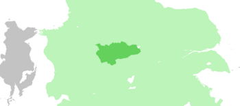
 Location on Pelia continent | |
| Status | Independent State |
| Capital | Velmegun |
| Largest city | Akan'aktid |
| Official languages | Standardized S'Lanter |
| Demonym(s) | S'Lanter-Okurlun (sing), S'Lanter (adj), S'Lanter (plur) |
| Population | |
• 1610 census | 101,432,390 |
| GDP (nominal) | estimate |
• Total | $2.12 trillion |
• Per capita | $20,990.10 |
| Gini (1610) | 38.7 medium |
| HDI (1610) | 0.821 very high |
| Currency | Okur'azch (OKZ) |
| Date format | mm/dd/yyyy |
| Driving side | right |
| Calling code | +1 |
| Internet TLD | .sl |
The Okur-Federation of S'Lanter, commonly referred as S'Lanter, is a landlocked nation located in the southwest of the Blue Steppe on the Pelia continent. It consists of 87 holts, a federal district, and five unincorporated territories. With a population of over 100 million, it is the most populous country in the Blue Steppe region of the Pelia continent. It is the predominant nationstate of the Okurluns, a species of sapient bipedal Okur'oden. While Okurluns make up 90.3% of the population, members of other species claim citizenship in S'Lanter.
Etymology
S'Lanter is roughly translated to "kindred", the term becoming a national nomer in the early 1500s as Okurlun tribes unified under the Prat'chk clan.
History
Geography
S'Lanter geographic borders are defined in the west by the Olki Alps, the Trans-Lumarian Steppe in the north, the R'ffti River Valley in the south, and the Trans-Lumarian Aligriftor Lake in the east. While the majority of the land area consists of the open grassland of the Blue Steppe, there are meadows, deciduous forests, isolated mountain ranges, and cold, arid plateaus.
