Khijovia: Difference between revisions
| Line 178: | Line 178: | ||
===Physical Geography=== | ===Physical Geography=== | ||
Situated within the expansive geographical region known as the [[High West]], the Khijovian landscape showcases diverse features, making it one of the most varied regions on the [[Pelia|Pelian]] continent. Bordered by the [[Kyldigard|Kyldigardian]] region to the north, Khijovia is geographically enclosed by the [[Clastoclite range]] to the east and the [[Stornic massif]] to the south. | |||
The Khijovian terrain exhibits a broad spectrum of characteristics, with a prevalence of hilly areas compared to flat or mountainous zones, maintaining an average altitude of approximately 730 meters above sea level. The mountainous landscapes extend across the eastern expanse of the nation, encompassing a significant portion of the western Clastoclite system. The highest peaks in Khijovia are situated in the central Clastoclites, where numerous summits exceed 5000 meters, including the remarkable [[Mount Eletherium]] (5800 meters), standing as the loftiest peak in the Clastoclite range. Over time, the Khijovian mountainous region has been shaped by an ancient Cenozoic glacial mass, leaving behind extensive moraines flanking the western Clastoclite slope, forming expansive highlands in the north and numerous shallow valleys amidst the southern hills. | The Khijovian terrain exhibits a broad spectrum of characteristics, with a prevalence of hilly areas compared to flat or mountainous zones, maintaining an average altitude of approximately 730 meters above sea level. The mountainous landscapes extend across the eastern expanse of the nation, encompassing a significant portion of the western Clastoclite system. The highest peaks in Khijovia are situated in the central Clastoclites, where numerous summits exceed 5000 meters, including the remarkable [[Mount Eletherium]] (5800 meters), standing as the loftiest peak in the Clastoclite range. Over time, the Khijovian mountainous region has been shaped by an ancient Cenozoic glacial mass, leaving behind extensive moraines flanking the western Clastoclite slope, forming expansive highlands in the north and numerous shallow valleys amidst the southern hills. | ||
The plains of Khijovia encompass various areas, including the [[Catridian plain]], formed by the alluvial expanses of the [[Thevre]] river and its tributaries, extending to [[Pyrisia]]; the [[Betronic plains]], elevated plains along the coasts of [[Androvia]] and [[Charonthia]]; and the [[Platic plain]], an elongated flat valley of tectonic origin encircling the [[Axiomia Lake]], stretching from [[Cassiopia]] to [[Carcassonia]]. | The plains of Khijovia encompass various areas, including the [[Catridian plain]], formed by the alluvial expanses of the [[Thevre]] river and its tributaries, extending to [[Pyrisia]]; the [[Betronic plains]], elevated plains along the coasts of [[Androvia]] and [[Charonthia]]; and the [[Platic plain]], an elongated flat valley of tectonic origin encircling the [[Axiomia Lake]], stretching from [[Cassiopia]] to [[Carcassonia]]. | ||
Revision as of 20:54, 18 August 2024
This article is incomplete because it is pending further input from participants, or it is a work-in-progress by one author. Please comment on this article's talk page to share your input, comments and questions. Note: To contribute to this article, you may need to seek help from the author(s) of this page. |
Ascended Kingdom of Khijovia Khijovïænnĕ Krønïæ Mœþra | |
|---|---|
| Motto: "Œþ ëna Ðrâconïæ nıəva Aþtonо̆e voyra" "Love of the Motherland is our only Law" | |
| Anthem: Khıjovïænnĕ Ara Ghanþо̆ra The Glorious Khijovian Anthem | |
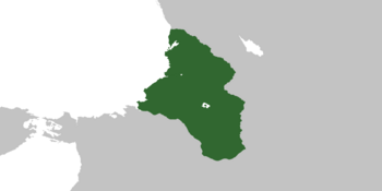
 Lands and surroundings of the Ascended Kingdom of Khijovia, 1613 AR | |
| Capital | Kleitore |
| Largest | Xoviah |
| Official languages | Khijovian |
| Ethnic groups | Humans (82.9%) Sheepfolk (8.6%) Goatfolk (6.4%) Kyleth (2.1%) |
| Religion | Aravianism (94.2%) Other (3.5%) Atheism (2.3%) |
| Demonym(s) | Khijovian, Khijovic |
| Government | Feudalistic Constitutional Monarchy |
• Ascended King of Khijovia | Arcadion II |
• Ascended Queen of Khijovia | Carevia I |
| Legislature | Royal Parliament |
| Establishment | |
• Foundation of the Ascended Kingdom | June 3, 1607 AR |
| Area | |
• Land Area | 1,386,546 km2 (535,348 sq mi) |
• Water (%) | 6.3 |
| Population | |
• 1613 AR estimate | 127,085,900 |
• Density | 86.6/km2 (224.3/sq mi) |
| GDP (nominal) | estimate |
• Total | $ 225,000,000,000.00 |
• Per capita | $ 1,772.00 |
| Currency | Shonenor (SHN) |
| Date format | dd/mm/yy |
| Driving side | right |
Khijovia (Khijovian: Khıjovïæ [kɪjəʊviə]), officially the Ascended Kingdom of Khijovia, is an isolationist semi-feudalistic constitutional monarchy situated in northwestern Pelia, with Kleitore serving as its capital. It shares its borders with Kyldigard to the north and Prestore to the south, while the Kesper Sea lies to the west. It occupies the northern portion of the High West region and possesses several overseas colonies, including the Recondian archipelago in the Wintry Ocean, Thenoria in northern Ilus, and Yvrethia in northeastern Pelia, which is the largest and most significant of these territories. Mainland Khijovia has an estimated population of approximately 110 million, making it the most populous country in Pelia. The colonial territories contribute an additional 17 million inhabitants, bringing the total population of Khijovia to 127 million. Known for its deeply spiritual society, the nation has maintained a unique connection with the magical arts throughout its history, with approximately 94% of the population belonging to the Aravian faith.
During ancient times, Khijovia served as a crossroads for numerous neolithic cultures. Thriving city-states emerged during the Era of Ruin, preserving their cultural identity and language staunchly against external influences. Notwithstanding the upheavals in the rest of Sparkalia, Khijovia remained isolated, relatively unaffected by wars and famines until the catastrophic Abheric Wars and the subsequent collapse of the city-state system around 277 BR, ushering in the Barren Age and marking the end of the Archaic Age in Khijovian history. Despite suffering continental amnesia during the Great Shuffle, Khijovian culture persisted. In 289 AR, the Kveutonian civilization conquered and divided Khijovia into governatorates, making it a crucial economic and cultural hub within the Kveutonian Empire. The empire reached its zenith around 415 but dissolved in 502, leading to the formation of independent statelets and religious-monastic military orders, including the influential Jovianic Order. Over the centuries, cities transformed into feudal lordships, giving rise to Khijovian principalities, duchies, counties, and marquisates. The Grand Duke of Klettoria, Zenon the Great, initiated a national unification campaign in 1152, defeating the rival House of Arenia and establishing the Kingdom of Khijovia on July 11, 1161. Despite centuries of rule, the Zenonian Dynasty faced a coup on January 28, 1534, leading to the formation of the relatively short-lived Khijovian Federation. In May 1607, Prince Arcadion of the House of Zenon reclaimed power and officially founded the Ascended Kingdom of Khijovia on June 3, 1607.
Etymology
The origin of the name Khijovia has long intrigued linguists and historians, prompting diverse reconstructions. While some theories delve into etymological roots, others are steeped in historical narratives, including the intriguing notion of an ancient pre-Shuffle king named Khjvonnə in popular traditions.
One prevalent theory suggests that the name stems from Khyjvīə, an exoethnonym used by the Koritians for a tribe residing in the neighboring Aldoria region. Another hypothesis, not mutually exclusive, proposes that these people venerated a pagan deity, Khœva, making the name signify "inhabitants of the land of Khœva."
History
Primordial Aeon
Prehistory
Approximately 35,000 years ago, the Acreatics, a nomadic civilization, were the first known inhabitants of Khijovia. Evidence from the Yllia archaeological site on the Pletorian coasts reveals complex burial practices and shamanic rituals. Despite the Neolithic agricultural revolution, the Acreatics relied on hunting and gathering until climatic changes around the twelfth millennium BR led them to migrate inland, transitioning to transhumant farming and eventually settled agriculture, marking the end of their nomadic lifestyle.
Protohistory
The shift to agriculture and livestock in Khijovia led to population growth and early housing settlements, transitioning from matriarchy to patriarchy for village defense. The Copper Age saw distinct cultures like Venatorian, Khantan, and Koritian, while the Bronze and Iron Ages introduced the Xomian and Kleitite cultures. By 1400 BR, villages grew into cities, fostering interdependence with rural areas and developing a social hierarchy, forming the basis for an aristocratic caste.
Era of Ruin
Archaic Age
During the Era of Ruin in Khijovia, urban centers developed into autonomous city-states, each adopting distinct forms of governance. Some embraced theocratic rule, where priests wielded political power as representatives of the gods. Others transitioned to monarchies, separating political authority from religious influence, while some followed a timocratic system led by aristocrats based on land ownership and military prowess. Over time, democracy began to emerge from aristocratic roots, gradually granting citizens equal rights and reshaping political dynamics through alliances to mitigate internal strife despite ongoing political tensions.
League Phase
Abheric Wars
Barren Age
Khijovic Middle Ages
Syhric Advent
Nova Antiquity
Kveutonian Age
Jovianic Domination
Modern Era
Surgence Epoch
Zenonian Age
Khijovian Renascence
Koronian Civil War
Contemporary Age
Federalist Parenthesis
Ascension Period
Geography
Physical Geography
Situated within the expansive geographical region known as the High West, the Khijovian landscape showcases diverse features, making it one of the most varied regions on the Pelian continent. Bordered by the Kyldigardian region to the north, Khijovia is geographically enclosed by the Clastoclite range to the east and the Stornic massif to the south.
The Khijovian terrain exhibits a broad spectrum of characteristics, with a prevalence of hilly areas compared to flat or mountainous zones, maintaining an average altitude of approximately 730 meters above sea level. The mountainous landscapes extend across the eastern expanse of the nation, encompassing a significant portion of the western Clastoclite system. The highest peaks in Khijovia are situated in the central Clastoclites, where numerous summits exceed 5000 meters, including the remarkable Mount Eletherium (5800 meters), standing as the loftiest peak in the Clastoclite range. Over time, the Khijovian mountainous region has been shaped by an ancient Cenozoic glacial mass, leaving behind extensive moraines flanking the western Clastoclite slope, forming expansive highlands in the north and numerous shallow valleys amidst the southern hills.
The plains of Khijovia encompass various areas, including the Catridian plain, formed by the alluvial expanses of the Thevre river and its tributaries, extending to Pyrisia; the Betronic plains, elevated plains along the coasts of Androvia and Charonthia; and the Platic plain, an elongated flat valley of tectonic origin encircling the Axiomia Lake, stretching from Cassiopia to Carcassonia.
Numerous Khijovian isles are grouped in small archipelagos, such as Cheronia off the Charonthic coasts, and Recondia, a polar archipelago situated within a deep lagoon connected to the Wintry Ocean, entirely surrounded by ice cap glaciers.
Geology
Khijovia's geological history is defined by the Late Cenozoic collision between the Kesperian and northern Pelian plates, resulting in the Clastoclitic chain and the accretion of microplates. This area is highly active geologically, with notable Neogene volcanism and seismicity. Studies have identified two main paleogeographic domains separated by the Clastoclites|Clastoclitic line: the Pelian domain and the Kesperian domain, which includes the High West and the Kesperian marine basin. The Khijovian subregion features sedimentary rocks dating from the Precambrian to the Quaternary and Cambrian metamorphites in the southeast. Khijovia's diverse geological features contribute significantly to the understanding of north-western Pelia's geology.
Hydrography
Climate
Meteorology
Wildlife
Politics
State Structure
Administrative Division
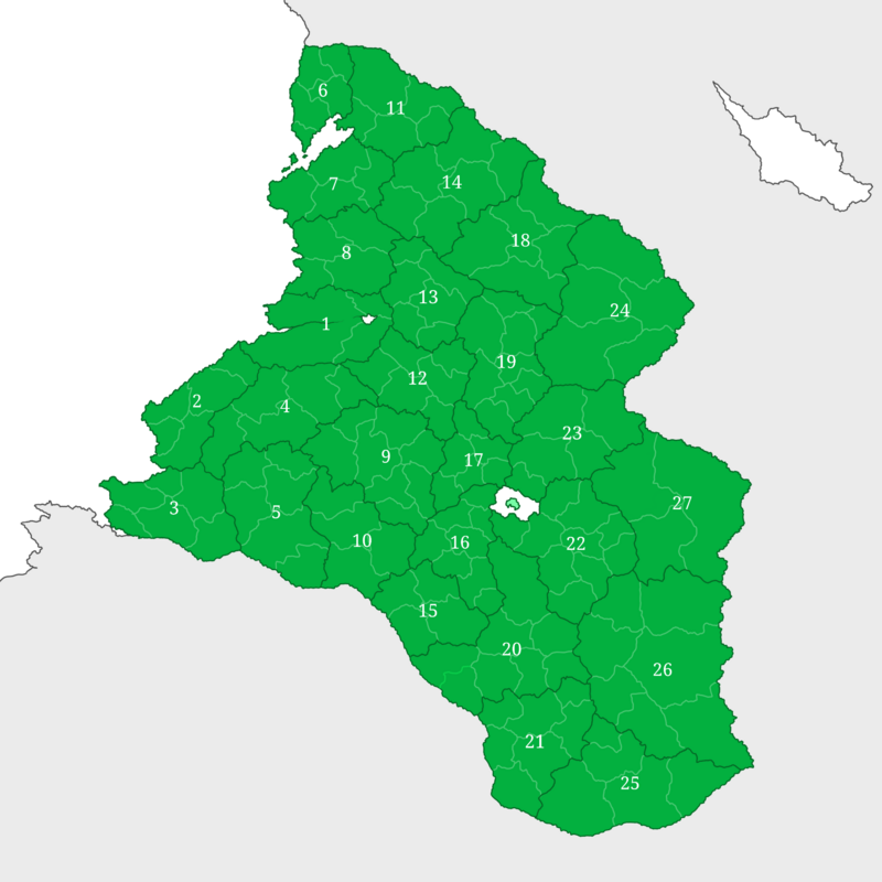
The territory of the Ascended Kingdom of Khijovia is divided into 27 administrative regions, each corresponding to a semi-feudalistic entity, and further subdivided into 155 municipalities.
| Region | Map of the Khijovian Administrative Regions and Municipalities | |
|---|---|---|
| 1 | Klettoria | 
|
| 2 | Pyrisia | |
| 3 | Lluria | |
| 4 | Qaylasiah | |
| 5 | Atredia | |
| 6 | Chondia | |
| 7 | Charonthia | |
| 8 | Androvia | |
| 9 | Ketheria | |
| 10 | Garganthia | |
| 11 | Yvernia | |
| 12 | Kharpovia | |
| 13 | Profania | |
| 14 | Venatoria | |
| 15 | Teutoria | |
| 16 | Koritia | |
| 17 | Kalkhovia | |
| 18 | Bellatoria | |
| 19 | Cassiopia | |
| 20 | Aldoria | |
| 21 | Sofolenia | |
| 22 | Carcassonia | |
| 23 | Corkovia | |
| 24 | Karkarovia | |
| 25 | Rhodontia | |
| 26 | Varkadia | |
| 27 | Akrocanthia | |
| * | Axiomia | |

