Ventismar: Difference between revisions
Notbyzantium (talk | contribs) |
No edit summary |
||
| Line 96: | Line 96: | ||
| 91,183,161 | | 91,183,161 | ||
| 352,945 km² | | 352,945 km² | ||
|- | |||
|width=200px|{{flag|Layfet}} | |||
| Nordipolica | |||
| 4,310,500 | |||
| 28,311 km² | |||
|- | |- | ||
|} | |} | ||
Revision as of 02:51, 5 September 2019
 | |
| Area | 11,880,128 km² (4,586,943 sq mi) |
|---|---|
| Demonym | Ventismarian |
| Countries | 17 Sovereign Countries |
| Languages | Most common languages first: French · English · Lindian |
| Time zones | UTC-1 to UTC+3 |
| Largest cities | Largest Urban Areas: Lièvremont, Artwingen, Constantinople |
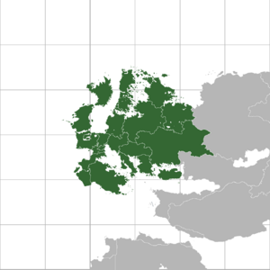
Ventismar is a continent located in the northern hemisphere of Sunalaya. It is bordered by the Arctic Ocean in the north, the Lutetian Ocean in the west, Ophion in the east and Azarah in the south.
Ventismar covers around 11,880,000 square kilometres (4,586,000 sq mi). Politically Ventismar is divided into 17 sovereign states of which Rezua is the largest in size. The Ventismarian climate is largely affected by warm Lutetian currents from the west and cold arctic currents from the north-east. This allows winters to be warmer in Western Ventismar and summers with more precipitation.
Ventismar is considered the be the birthplace of western civilization. The fall of the Imperium d'Fleuves marked the end of the ancient era of Sunalaya and the start of the nationspring where Lindenholt, Ripuaria and Capsland became the main civilizations on the continent. After a period of infighting between the local kings and lords known as the Kingdoms Era, several empires rose to the colonial age of Sunalaya.
Ventismar was at the heart of the colonial age in the 15th and 16th century. The first colonies were established by Ripuaria and Capsland in Dogmana and later colonies of Lindenholt were created in Corentia. This period marks exploration and exploitation of locals.
In 1976, the Treaty of Freiburg was signed, and it became the basis for the future of the continent, united under the Ventismar Union which was finally formalized in 1979. The Ventismar Union Parliament which to this day continues to legislate and rule over most of the Ventismarian countries was created in 2015, the same year the first Ventismar Union President Art van de Lay was elected; after serving a single term Anthony Hubris was elected, who is the incumbent VU president.
Name
In classical Proto-Ventismarian mythology, Venti was a Ripuarian Prince, who was known to have been born with major birth defects. The word Ventismar derives from his name. The name contains the elements Smar, "Retarded, Autist"[citation needed] in the ancient Proto-Ventismarian language.
There has been atempts to connect the name with the synonyms for "smart", "intelligent", "intelecual" but these attempts have failed miserably after researchers and linguists understood that in every language on Sunalaya, "Ventismar" translates to "A group of autists"[citation needed].
Politics
The political map of Ventismar is derived from the Great Wars, after which the whole map of the continent had to be redrawn. Most countries in Ventismar are Parliamentary Democracies, in most cases in a form of a Republic, but in many cases also in the form of a Monarchy. Most of Ventismar's remaining monarchies are constitutional. Two autocratic regimes remain in Ventismar with Tyrenes as a totalitarian dictatorship and Romaikos as an absolute monarchy.
Since the second half of the 20th century, Ventismar has seen an age of integration between it's countries. First through trade treaties and free movement treaties and later with the creation of the Ventismar Union and it's parliament which now connects most of the countries on the continent with similar legislations, regulations and forms a bloc on the global economic scene.
List of Countries
| Name | Capital | Population | Area (km2) |
|---|---|---|---|
| Ålhavn | 103,424,840 | 652,260 km² | |
| Burton | 86,913,628 | 716,236.5 km² | |
| Felsinia | Please Fill Me | Pretty Please | |
| Artwingen | 73,453,603 | 410,880 km2 | |
| Eomeria | 130,564,183 | 1,865,089 km² | |
| Lièvremont | 106,982,400 | 268,800 km² | |
| Constantinople | 164,231,475 | ??? | |
| Volokarn | 23,856,745 | Very Sad | |
| Sokaczow | 91,183,161 | 352,945 km² | |
| Template:Country data Layfet | Nordipolica | 4,310,500 | 28,311 km² |