Kveuton: Difference between revisions
Jump to navigation
Jump to search
SouprRacwn (talk | contribs) No edit summary |
SouprRacwn (talk | contribs) No edit summary |
||
| Line 3: | Line 3: | ||
{{Infobox country | {{Infobox country | ||
|micronation = <!--yes if a micronation--> | |micronation = <!--yes if a micronation--> | ||
|conventional_long_name = The Kveutonian | |conventional_long_name = The Kveutonian People's Federation of Socialist Republics | ||
|native_name = | |native_name = | ||
|common_name = Kveuton | |common_name = Kveuton | ||
|status = Independent | |status = Independent | ||
|image_flag = | |image_flag = Flag of KPFSR.png | ||
|alt_flag = <!--alt text for flag (text shown when pointer hovers over flag)--> | |alt_flag = <!--alt text for flag (text shown when pointer hovers over flag)--> | ||
|flag_border = <!--set to no to disable border around the flag--> | |flag_border = <!--set to no to disable border around the flag--> | ||
| Line 13: | Line 13: | ||
|alt_flag2 = <!--alt text for second flag--> | |alt_flag2 = <!--alt text for second flag--> | ||
|flag2_border = <!--set to no to disable border around the flag--> | |flag2_border = <!--set to no to disable border around the flag--> | ||
|image_coat = | |image_coat = KPFSR Coat of Arms.png | ||
|alt_coat = <!--alt text for coat of arms--> | |alt_coat = <!--alt text for coat of arms--> | ||
|symbol_type = <!--emblem, seal, etc (if not a coat of arms)--> | |symbol_type = <!--emblem, seal, etc (if not a coat of arms)--> | ||
| Line 23: | Line 23: | ||
|other_symbol_type = <!--Use if a further symbol exists, e.g. hymn--> | |other_symbol_type = <!--Use if a further symbol exists, e.g. hymn--> | ||
|other_symbol = | |other_symbol = | ||
|image_map = | |image_map = Kveuton map.png | ||
|loctext = <!--text description of location of country--> | |loctext = <!--text description of location of country--> | ||
|alt_map = <!--alt text for map--> | |alt_map = <!--alt text for map--> | ||
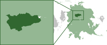
|map_caption = | |map_caption = '''Location on [[Pelia]] continent''' | ||
|image_map2 = <!--Another map, if required--> | |image_map2 = <!--Another map, if required--> | ||
|alt_map2 = <!--alt text for second map--> | |alt_map2 = <!--alt text for second map--> | ||
| Line 131: | Line 131: | ||
}} | }} | ||
=Etymology= | |||
=History= | |||
==Modern history== | |||
=Geography= | |||
Kveutonian geographic borders are defined in the west by the Olki Alps, the Trans-Lumarian Steppe in the north, the R'ffti River Valley in the south, and the Trans-Lumarian Aligriftor Lake in the east. While the majority of the land area consists of the open grassland of the Blue Steppe, there are meadows, deciduous forests, isolated mountain ranges, and cold, arid plateaus. | |||
=Politics= | |||
==Government== | |||
===List of Ministries=== | |||
===Foreign Relations=== | |||
=Culture = | |||
==Holidays/celebrations== | |||
==Music== | |||
===Festivals=== | |||
==Media== | |||
==Fashion== | |||
=Economy= | |||
==Industry== | |||
=Demographics= | |||
==Religion== | |||
==Language== | |||
==Education== | |||
==Health== | |||
[[Category:Countries (Sparkalia)]] | |||
{{Template:Sparkalia}} | {{Template:Sparkalia}} | ||
Latest revision as of 21:38, 1 March 2024
This article is incomplete because it is pending further input from participants, or it is a work-in-progress by one author. Please comment on this article's talk page to share your input, comments and questions. Note: To contribute to this article, you may need to seek help from the author(s) of this page. |
The Kveutonian People's Federation of Socialist Republics | |
|---|---|
 Location on Pelia continent | |
| Status | Independent |
| Official languages | Kveutonian |
| Demonym(s) | Kveutonian |
Etymology
History
Modern history
Geography
Kveutonian geographic borders are defined in the west by the Olki Alps, the Trans-Lumarian Steppe in the north, the R'ffti River Valley in the south, and the Trans-Lumarian Aligriftor Lake in the east. While the majority of the land area consists of the open grassland of the Blue Steppe, there are meadows, deciduous forests, isolated mountain ranges, and cold, arid plateaus.

