Lorecia
Jump to navigation
Jump to search
This article is incomplete because it is pending further input from participants, or it is a work-in-progress by one author. Please comment on this article's talk page to share your input, comments and questions. Note: To contribute to this article, you may need to seek help from the author(s) of this page. |
 | |
| Area | 20,029,500 km2 (7,733,400 sq mi) |
|---|---|
| Population | 1.426 billion? |
| Population density | 71.2/km2 (c. 184/sq mi) |
| Demonym | Lorecian |
| Countries | 13 |
| Languages | List of languages |
| Time zones | UTC+0 to UTC+4 |
| Largest cities | |
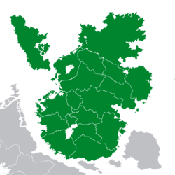
Lorecia is an insular continent in northern Astyria. It is divided from its southern neighbour, Teudallum, by the Putin Strait. It is bounded to the north by some water, to the east by the Atlpacinarcticadian Ocean, and to the west by the Mederano Sea and the Wet Water.
Lorecia is the smallest of Astyria's five continents, with a land area of approximately 20,029,500 square kilometres (7,733,400 sq mi).
Politics
List of states and territories
The list below includes the countries and territories in Lorecia.
| Flag | Arms | Name | Area (km) | Population | Population density (per km) | Capital | Name(s) in official language(s) |
|---|---|---|---|---|---|---|---|
| Aurora Confederacy | ? | ? | ? | Valeria-Port Aurora | Aurora Confederacy | ||
| Aquitayne | ? | ? | ? | Telora | Aquitayne | ||
| Aswick | ? | ? | ? | Winchester | Aswick | ||
| Albeinland | ? | ? | ? | Castelby | Albeinland | ||
| Noordenstaat | ? | ? | ? | Koninstad | Noordenstaat | ||
| Nidwalden | ? | ? | ? | Cologne | Nidwalden | ||
| Scanonia | ? | ? | ? | Kristianstad | Skånien | ||
| Earent | ? | ? | ? | Eanbyre | Earent | ||
| Haguenau | ? | ? | ? | [[Angoulême] | Haguenau | ||
| Fyngaria | ? | ? | ? | Kíjmafőrsz | Fjóngariká | ||
| Mizialand | ? | ? | ? | Heleventia | La Mize, Mizialand | ||
| Template:Country data Belka | Belka | ? | ? | ? | Kíjmafőrsz | Fjóngariká | |
| Template:Country data Bhormakaro | Bhormakaro | ? | ? | ? | Purma | ? | |
| Nouvel Ecosse | ? | ? | ? | Edinburgh | Nouvel Ecosse | ||
| Template:Country data Arstotska | Arstotska | ? | ? | ? | ? | ? | |
| Template:Country data Plaeteissen Adler | Pläteissen Adler | ? | ? | ? | ? | ? |