Paraboca
Federation of Paraboca | |
|---|---|
|
Flag | |
 | |
| Capital | Cardoza |
| Recognised national languages | Spanish, English |
| Government | Semi-Constitutional Federal Republic |
• President | Garr'n Cardoza II |
| Establishment | |
• Empire of Paraboca | 1693 |
• Paraboca breaks apart | 1879 |
• Federalization and Constitution of Paraboca | 1910 |
| Population | |
• 2020 estimate | 32,800,000 |
• 1860 census | 572,100,000 |
| Currency | Parabocan quoti |
| Date format | mm-dd-yyyy |
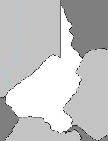
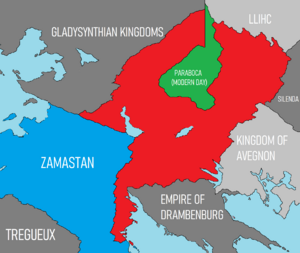
The Federation of Paraboca is a nation located on the continent of Euronia in the Coalition of Crown Albatross. It is landlocked and bordered by Gladysynthia to the west, Llihc to the east, Avergnon, East and West Chanchajilla to the south. It was the name sake of a massive empire which existed from 1693 until its assimilation in 1879, a period of 185 years. It grew as an empire during the late 18th and early 19th century, though its attempted invasion of Zamastan in 1871 led to the Parabocan War, which involved several nations including Chanchajilla (now East Chanchajilla and West Chanchajilla), and parts of Gladysynthia, Zamastan and Rio Palito. Paraboca's massive defeat reduced their imperial colonies by nearly a third, and revolutions sprung up around the empire which ultimately led to the collapse of its government due to infighting in 1879. The nation federalized in 1910 and began opening up to foreign aid.
In the century following the collapse of the empire, Paraboca faced massive economic turmoil in the form of rapid inflation and unemployment, as well as several depressions and a series of sporadic armed uprisings. In the recent years of the 21st century, however, Paraboca has registered notable success in reducing child mortality, population control, combating natural disasters, women's empowerment, earning foreign exchange through the export of textiles, and using micro-credit to alleviate poverty. However, the country continues to face the challenges of the lasting remembrance of the 1954 Diwingya genocide and refugee crisis, terrorism, corruption, and the erratic effects of climate change in the forms of wildfires and glacial melt.
History
Indigenous Peoples
The earliest human artifacts in Paraboca are chips of stone tools found near campfire remains in the Valley of Cardoza and radiocarbon-dated to circa 10,000 years ago. Parabcoa has sites of domestication of maize, tomato, and beans, which produced an agricultural surplus. This enabled the transition from hunter-gatherers to sedentary agricultural villages beginning around 5000 BC.
In the subsequent formative eras, maize cultivation and cultural traits such as a mythological and religious complex, and a vigesimal numeric system, were diffused from the central mountainous cultures to the rest of the Parabocan culture area. In this period, villages became more dense in terms of population, becoming socially stratified with an artisan class, and developing into chiefdom. The most powerful rulers had religious and political power, organizing the construction of large ceremonial centers developed.

Early Age
Empire
1700-1800 Conquests
Throughout the late 1700's and early 1800's, the military dictatorships of Paraboca thrived to conquer territory to reach their imperial boundaries to the Olympic Ocean. In 1788, the captured Vilanja after a month-long siege, ultimately annexing much of the eastern regions of Chanchajilla into their empire. Thirty years later in 1819 in another bout for resource-fueled expansion, a more aggresive push westward brought the Parabocan armies to Ivora. With the northern stretch of the Chanchajillan provinces held, and much of the southern Lake Greening shoreline under their control. Throughout the next twenty years, Parabocan armies began to seize area around the lake and eventually into indigenous Zamastanian lands in current day Redeemer’s Land, where the fledgling tribes were either conquered or retreated north towards the newly established nation of Zamastan. President Tomias Hapson established projects to house and protect fleeing indigenous refugees, one of the first refugee-crisis management projects in history.
In 1832, Paraboca invaded the Kingdom of Mayotte, seizing their southern shoreline and effectively capturing their access to the Toyana Ocean. In 1840, they moved northward and captured territory that bordered Zamastan's newly established frontier. President Hapson met with Parabocan leader Osi Jo Oberk when the latter traveled to Tofino, and aggressively talked him down from any more aggression westward, to which the Parabocans agreed. Instead of expanding southwest, the Parabocans moved directly south, capturing swaths of land up to just shy of the southern border of Avergnon.
In 1850, Zamastan was victorious against the Kingdom of Lousianian in the Louise Mountains War and annexed their former enemy. Avi Taures, concerned about his nation's ability to wage war, began amassing troops on the border. He declared truthfully, according to historians, that he would not fight Paraboca unless they attacked, and that the troops were simply there for defensive purposes after being faced with the Lousianian invasion three years prior. Taures died in 1868, handing the presidency over to William Castovia. Castovia was more confident than his predecessor, and pulled thousands of troops from the southern border in a show of good faith towards the Parabocans, who had not betrayed their agreement in nearly thirty years. Also in 1868, Manuelo Cardoza became President of Paraboca, and began secretly planning for an invasion of southern Zamastan. In 1870, Cardoza also pulled his troops away from his southern border so as to appear peaceful against their neighbor.
Parabocan War
On January 5th, 1871, Manuelo Cardoza ordered hundreds of contingents of the Parabocan army to advance into southern Zamastan along a nearly 500 mile long stretch of land. The Parabocans descended from the Redeemer's Land highlands and into the prairie and crop regions of Pahl, seizing villages and catching Zamastanian divisions off guard. By the end of January, nearly the entirety of the southern quarter of Zamastan was under Parabocan control. The Zamastanian army was divided as contingents and divisions were surrounded and caught behind enemy lines. As President Castovia responded by sending nearly the whole force of 300,000 troops to face the 700,000 invading Parabocans, divisions that were behind enemy lines attempted to break back to their Zamastanian brothers. On January 16th, 300 Zamastanian soldiers stuck in Parabocan territory attempted to defend the city of Addleview from advancing enemy forces, but failed to keep control of the city. However, they managed to take over 6,000 enemy soldiers with them as they fought to the end.
For the first month of the war, Zamastanian forces consistently faced loss upon loss in battles across the frontier. Parabocan armies far outnumbered the Zamastanians, and their tactics in overwhelming conquer warfare was too aggressive for most generals to force a counter attack. In February, Zamastanian forces were soundly defeated at the Battle of Duncan, and Parabocan forces nearly completely raised the city of Duncan to the ground. It became clear to the Zamastanian leaders that the Parabocans were fighting a total war and were not concerned about civilian casualties. In Duncan alone, over 10,000 non-combatant civilians were killed.


