Hacyinia
This article is incomplete because it is pending further input from participants, or it is a work-in-progress by one author. Please comment on this article's talk page to share your input, comments and questions. Note: To contribute to this article, you may need to seek help from the author(s) of this page. |
Tannu Hacyinia | |
|---|---|
 Flag | |
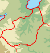
 Location of Hacyinia on Kylaris in dark green | |
 Hacyinian territory under central control in dark green, uncontrolled territory in light green (The Yoloten), claimed territory in Lavana in yellow & claimed territory in Zomia in orange (Outer Hacyinia) | |
| Capital and largest city | Dabulug |
| Recognised national languages | Pardarian, Gaullican |
| Recognised regional languages | Dehgan, Oroqmen, Ziba, Majgar, Ukilen |
| Other languages | Chanwan |
| Ethnic groups | 40% Oroqic 40% Majgar 60% Oroqmen 22% Pardarianic 20% Asud 40% Dehgan 40% Gurani 15% Ukilenic 80% Ukilens 20% Khoits 15% Chanwan 6% Dezevauni 2% Other |
| Religion | 75% Badist 10% Irfanic 5% Chanwan Folk Religion 4% Solarian Catholicism 3% Zohism 3% Other |
| Demonym(s) | Hacyinian |
| Government | Devolved unitary semi constitutional monarchy |
• Khan | Makbule Arda Khan |
| Erasyl Rinat | |
| Legislature | National Kurultai |
| Jïırma jeti Töñirek ("Circle of 27") | |
| Buqaranıñ Kurultai ("Council of the Masses") | |
| Establishment | |
• Bessharian Khanate established | 1789 |
• Formation of the Hacyinian Khanate after incorporating xxx and xxx | 1845 |
• Establishment of the Kingdom of Hacyinia | 1935 |
| Area | |
• Total | 1,031,116.801 km2 (398,116.423 sq mi) |
| Population | |
• 2022 census | |
• Density | 35.83/km2 (92.8/sq mi) |
| GDP (PPP) | 2021 estimate |
• Total | $572.72 billion |
• Per capita | $15,500 |
| GDP (nominal) | 2021 estimate |
• Total | $221.70 billion |
• Per capita | $6000 |
| Gini | 41.9 medium |
| HDI (2020) | 0.654 medium |
| Currency | Hacyinian som |
| Date format | dd-mm-yyyy |
| Driving side | right |
| Internet TLD | .ha |
Hacyinia, officially known as Tannu Hacyinia, is a country in Coius. It borders Dezevau and Lavana to the east, Zorasan to the north and west, Shangea to the southwest, and Zomia to south. A landlocked country, it is the eastern edge of the Great Steppe. Hacyinia straddles the boundary between Southeast Coius, South Coius , and Greater Pardarian physically and culturally. The 31st largest country, Hacyinia occupies 1,031,116.80 km2. The 37 million citizens are multi ethnic, multi lingual and multi religious, who can trace their heritage from the mosaic of nomadic and settled peoples that have influenced the countries history. Population-wise, Hacyinia is roughly the 37th most populous country in the world.
Etymology
Hacyinia (Pronounced: /hɑ:sin.i.ə/, Listen) comes from the Old Pardarian word "hamicyia", meaning rebellious. The name originally comes from the nickname given to an Oroqic chieftain by the Arasanid Empire who perpetually continued to rebel and fight against Arasanid rule. Hacyinia eventually morphed into the name of the general steppe region between the Pardaric and Ziban politys, and remained as a placename until the establishment of the Hacyinian Khanate in 1845 where it then transferred to being the political name of the area as well.
History
Hacyinia has a long history, dominated mostly by the nomadic peoples that have ruled from the steppes as well as powerful empires who have conquered and held sway over the area. Although the area has long been inhabited with archeological records showing evidence of human settlement dating back to 6,000 BCE; the first recorded peoples in the area date back to the second millennia B.C with !Scythian/!Saka nomads domaining the steppes and settled Pardardian speaking city states establishing themselves in the eastern river deltas by Lake Zinabad, as well as in the foothills of the western mountains. The Chanwan had long called the highlands of western Hacyinia home and began establishing their own polity's in the highlands of the Huashan mountain range. In the southwestern steppe, in the modern day borderlands between Hacyinia, Zomia and Lavana, the proto-Oroqic Ashina held sway and competed with the !Scythians/!Saka for control of the steppe. The Ashina were able to establish several of their own powerful states controlling parts of Southeast Coius until just before the end of the 1st century CE.
Geography
Topographic map of Hacyinia
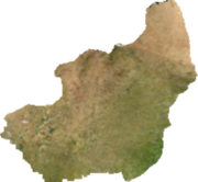
Satellite map of Hacyinia
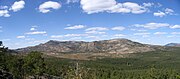
Photograph of western foothills in Bessharia.
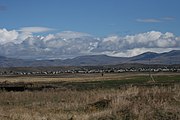
Photograph of the central steppe with a ger district in the background
- Haraz river.jpg
Photograph of the river deltas of Karasm

Lake Zinarud shoreline


At 1,031,116.80 km2, Hacyinia is the 15th largest in Coius, and the 31st largest in the world. It is slightly smaller than Behera and slightly larger than Belmonte. A landlocked country, it has a minimally varied terrain. The country is overwhelmingly steppe land. In the west there is the Transhuashan foothills and the plateau of the Great Steppe, while in the east there is the riparian inflowing rivers deltas to Lake Zinabad. The elevation of the country varies greatly however, with some areas being several thousand meters above sea levels and others being several hundred meters below sea levels. Generally elevation rises the in the west and closer to the Huashan mountains. The country is entirely considered to be within a Temperate grasslands, savannas, and shrublands biome, with a temperate climate. Precipitation is fairly high, and generally there is mild winters with warmer summers. The increasing desertification of nearby Zorasan has had a major impact on eastern Hacyinia in particularly, with notable land degradation impacting the agricultural output of eastern Hacyinia.
Arable land is at a minimum and mostly of the countries arable land is concreated in the east along in the river deltas and the shore of Lake Zinabad, or more limitedly in the west in mountain oases supplied by the melting glacial water of the Huashan mountains. The central steppes soil is incapable of supporting any sort of large scale agriculture, although it is more than capable of supporting large scale animal husbandry both historically and modern day. Much of the steppe has very limited water supply sans a few lakes and seasonal rivers that occasionally form. Water rights is a serious political concern, both domestically as well as internationally. Much of the water resources in the country are located in Karasm and are used to support extensive commercial agriculture. The shrinking of Lake Zinabad is of great concern to the Hacyinian government, and the Karasmic government before that.
The country is also periodically struck by zuds, which are occasional and harsh sudden changes in the climate which causes a large amount of livestock to die due to starvation, the elements and other factors. It does cause an extensive amount of economic and social upheaval for the predominantly rural, pastoral population as they are forced to move to urban areas or abroad in order to find work. Zud's are becoming increasingly more common as climate change and desertification impact the country.
Wildlife
Bactarian deer! Bactarian camels! Wolves! There's brown bears in Central Asia apparently? Snow leopards, cut & paste from stuff. Horses!
Demographics


Religion in Hacyinia
this is a test
Government and Politics
Hacyinia is a devolved unitary state. It operates as a semi-constitutional monarchy with a Unicameral legislature. The Head of State is the Khan while the Head of Government is the Prime Minister. The legislature, the National Kurultai, is comprised of 100 members. The Kurultai has limited powers, primarily dealing with budgetary matters, approving bills, questioning ministers, and establishing ad hoc commissions of inquiry to investigate the government's actions.
There is an advisory body, the xxx, comprised of xxx members who themselves are the leaders of the non-sovereign monarchys of the country. The advisory body has a broad swatch of powers,
The component monarchies of the country have been granted broad autonomy, with fairly significant political, administrative, and financial powers.
The lower house is elected via ***.
The government of Hacyinia is divided into *x amount of autonomous or semi-autonomous regions,
Economy
12th largest oil producer in the world (1,229,357 bbls per day), wealth of mineral resources. Other major exports include cotton and livestock. The economy is buoyed by being surrounded by larger, wealthier and stabler states. However, as a landlocked country, it's economy is also hindered by it's lack of natural sea access. It's wholly reliant on shipping it's goods through xxx because of political circumstances, and any freeze in relations would tank the economy.

Cotton is referred to as "white gold" in Hacyinia. Introduced by the Gaullicans, massive plantations were set up in eligible areas. Commercial growing of cotton spread throughout Hacyinia, and currently now operates as a massive cash crop for the country.
Culture
Culturally Besshar is more turko-mongol (Kazakh/Mongol), Karasm is more turko-persian (Tajik/Uzbek). Heavy influence from SE Asia for both Karasm + Bessharia, I imagine national food sorta similar to the Uyghurs/Hazaras? You know we be making rugs. Besshar is Badist, Karasm is Irfanic. some Euclean influence penetrated Besshar/Karasm.
- Architecture and arts: Those chechen towers common in Bessharia, Karasm is known for cities like !Bukhara and !Samarkand which is filled with beautiful Pardarian style buildings and architecture. - Clothing: folk clothing: Deels for Bessharia. Clothing style for Karasm I feel like would be more Persianized, (Iranian/Uzbek/Tajik traditional clothing). Traditional caps pretty common for both countries, with Telpeks common in Karasm + Papakha in Bessharia - the Doppa/Tubeteika/bakol kinda common throughout. I think we would see a mix of traditional/"modern" clothing, with Karasm being more "modern" and Bessharia being a bit more "traditional."
Sport
Kokpar also very popular, as well as other equestrian games/activities owing to countries steppe and horse culture. Mongolian wrestling/Turkic wrestling also popular. Something like Naadam very possible. Olympic weightlifting also very successful and popular sport between two countries. Rugby, in the union/league/sevens variants, is the most common team sport in the country. Has roots in "pushball" ïterwdop (kazakh)/ tülkhekhbömbög (mongolian) a traditional sport in the country that has roots in cultural influences gained during the tagmic migrations (Lelo burti)
Cuisine
Due to influence from neighboring Dezevau, ganome's are ubiquitous throughout the country. Hacyinia has a strong coffee culture.
Tattoos
Hacyinia has a rich history of tattooing. Various cultures in modern Hacyinia has practiced forms of tattooing throughout their history, and today its fairly common to see tattoos adorned on most people in Hacyinia. Despite the different styles of tattoos, almost all are rooted in beliefs that the tattoos are useful as charms to ward off evil spirts or to bring good luck to the tattooed person. Tattoos are typically more common in the western side of the country, as during the Gaullican colonization period the colonial authorities attempted to end the practice amongst various ethnic groups - albeit the practice continued in secret.
Historically, the Central Coian trade route and the Great Steppe trade routes helped spread the influence of Hacyinian tattoos across Coius.


