Isotama Islands: Difference between revisions
Jump to navigation
Jump to search
mNo edit summary |
mNo edit summary |
||
| Line 25: | Line 25: | ||
| [[Tomigusuku Prefecture]] | [[Urasoe Prefecture]] |<hr/> | | [[Tomigusuku Prefecture]] | [[Urasoe Prefecture]] |<hr/> | ||
}} | }} | ||
| country_largest_city = | | country_largest_city = [[Urasoe]] | ||
| country_largest_city_population = | | country_largest_city_population = | ||
| population = tbd | | population = tbd | ||
Latest revision as of 08:47, 13 January 2024
This article is incomplete because it is pending further input from participants, or it is a work-in-progress by one author. Please comment on this article's talk page to share your input, comments and questions. Note: To contribute to this article, you may need to seek help from the author(s) of this page. |
| Native name: | |
|---|---|
 | |
| Geography | |
| Location | Senria |
| Archipelago | Senrian archipelago |
| Administration | |
| Prefectures | |
| Largest settlement | Urasoe |
| Demographics | |
| Population | tbd (20XX) |
| Ethnic groups | Isotamans, Senrians |
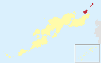
The Isotama Islands (Senrian: 이쏘따마쏘또우, Isotama-sotou; Isotaman: イスタマムルシマ, Isutama-murushima; Gyoumon: 磯珠諸島) are a group of volcanic islands located within the larger Senrian archipelago. They sit to the north of Tousuu, across the Sazanami Strait, on the border between the Lumine Ocean and the Bay of Bashurat.
The Isotamas are not a coherent island chain, and are typically divided between the Near Isotamas (consisting of Narazima and its associated islets) and the Far Isotamas (consisting of Iezima, Kumezima, and their associated islands and islets). [geography and climate]
[population and economics]
