Southeast Coius: Difference between revisions
No edit summary |
No edit summary |
||
| Line 16: | Line 16: | ||
|{{flag|Dezevau}} | |{{flag|Dezevau}} | ||
|{{flag|Lainan}} | |{{flag|Lainan}} | ||
|{{flagicon_image|Flag_of_the_Brabantine_Revolution.svg}} [[Nouvel Anglet]] (Gaullica) | |||
|{{flag|Terangau}} | |{{flag|Terangau}} | ||
|{{flag|Tinza}} | |{{flag|Tinza}} | ||
| Line 23: | Line 24: | ||
|dependencies = {{ubl | |dependencies = {{ubl | ||
|{{flagicon_image|Estmere.png}} [[Kingsport]] | |{{flagicon_image|Estmere.png}} [[Kingsport]] | ||
| | | | ||
}} | }} | ||
|unrecognized = {{flagicon_image|Flag_of_heijiang3.png}} [[Heijiang]] | |unrecognized = {{flagicon_image|Flag_of_heijiang3.png}} [[Heijiang]] | ||
Revision as of 05:03, 19 February 2020
 | |
| Area | 8,250,000 square kilometres |
|---|---|
| Population | 371,816,527 |
| Population density | 45/km2 |
| Religions | Badi, Irfan, Satyism, Solarian Catholicism |
| Demonym | Southeast Coian |
| Countries | |
| Dependencies | |
| Unrecognised states | |
| Languages | Brumhese, Estmerish, Gaullican, Kunak, Tinzan, Xiaodongese, Yirō, Ziba |
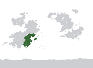
Southeast Coius is a region of the continent Coius, located in its southeast. It has x countries in it, with a population of x, and a wide variety of languages and religions, both indigenous and non-indigenous; these include Brumhese, Estmerish, Kunak, Tinzan, Yirō and Ziba, and Badi, Irfan, Satyism and Solarian Catholicism respectively. It is comprised primarily of developing countries with a history of colonialism; most of the region was Estmerish, Gaullican or Weranian at some time, but it mostly became independent after the Great War.
Southeast Coius is bordered by Bahia to the north and South Coius to the south while on the east it is bordered by the waters of the Banfura Sea. Geographically, Southeast Coius tends to be mountainous on the south and the island of Brumah while large plains and lower mountain ranges connect the region with Bahia to the north. With a mostly tropical climate, the region enjoys of a wide diversity on its flora and fauna; over the last years, Brumah and Dezevau have engaged on several projects of environmental protection specially on Dezevauni rainforests and Brumhese eastern coast, where from the homas Alday Islands to the Perawan Islands, the region has one of the largest protected areas of reefs and large maritime diversity.
The region covers about 8,250,000/km2 and has a population of 371,816,527 people which makes it one of the most populous regions in Coius and Kylaris. While the region has maintained itself as cultural and ethnically diverse, recent development and globalisation have raised concern over the lost of traditional costumes, however, despite long colonial rules, the region has maintained a large tradition over its native languages. In modern days, the region has maintained an active role on the foreign relations scene of the continent and an approach to have closer ties with nations of South Coius with Brumah and Tinza being members of the Council for Mutual Security and Development and Cavunia of the International Forum for Developing States. While democracy, economic freedom, human development and social inequality are still issues the region needs to work on, significant advances were made in the last decades accompanied of a stable economic growth.
Countries
| State | Area (km2) |
Population |
Density (/km2) |
GDP (nominal), Int$ (2019) |
GDP (PPP) per capita, Int$ (2019) |
HDI (2018 report) | Capital |
|---|---|---|---|---|---|---|---|
| 1,279,308 | 27,522,309 | 21.5/km2 | $215.800 bn | $15,463 | 0.718 | Manrıngol | |
| 1,834,685 | 129,899,450 | 70.8/km2 | 1.584 trillion | 20,899 | 0.818 | Bazadavo | |
| 1,668,477 | 112,261,345 | 67/km2 | $593.750 bn | $13,982 | 0.696 | Ladumra | |
| Template:Country data Tuarikai |