Auratia: Difference between revisions
No edit summary |
No edit summary |
||
| Line 106: | Line 106: | ||
=== Great War, September Clan, and the Rose Revolution === | === Great War, September Clan, and the Rose Revolution === | ||
== Geography and Climate == | == Geography and climate== | ||
The Auratian Peninsula has been measured to be rougly 240,886 km<sup>2</sup>. The country's exact area is difficult to estimate owing to the hundreds of islets and reefs that line the nation's coast. Much of Auratia's coastline is jagged and rocky, with huge spiral rock formations along the country's eastern seabord. Most inland areas are dominated by long chains of rolling hills. Flatlands nestled in valleys or {{wp|strath|straths}} are not uncommon, however. The peninsula's inland soil is known for its exceptionally good {{wp|tilth|tilth}}, and the inland states are the country's {{wp|breadbasket}} | |||
The terrain becomes much more mountaneous towards the border with [[Gaullica]] and [[Etruria]], where the mountains form an end chain of the Etrurian Mountains. Mount Orico is the country's tallest mountain, measured to soar above 2,145 meters (7037 ft). | |||
Many of the nation's largest cities sit on the Zatorra River—the largest river in Auratia—or its tributaries, including the nation's administrative capital [[Cienflores]]. Other historically important river is the Doro River. | |||
<gallery mode="packed" heights="130"> | |||
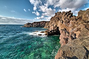
File:Lanzarote 4 Luc Viatour.jpg|Rocky shore near [[Hascara]] | |||
File:Tuscany (34445300666).jpg|Rolling hills | |||
File:La Pinareja01.jpg|Mount Orico | |||
File:Tagus River Panorama - Toledo, Spain - Dec 2006.jpg|Zatorra River running through [[Palma]] | |||
</gallery> | |||
=== Climate === | |||
Most of Auratia, particularly its coastal areas, boasts a {{wp|Mediterranean climate|Mediterranean climate}} characterized by dry summers and milder, wet winters. A {{wp|semi-arid climate|steppe}}-like climate can be observed in deeper inland regions, as is the case in some parts of [[La Virtud]], an inland state, with temperatures that vary depending on altitude. | |||
== Government and politics == | == Government and politics == | ||
Revision as of 05:01, 22 March 2020
This article is incomplete because it is pending further input from participants, or it is a work-in-progress by one author. Please comment on this article's talk page to share your input, comments and questions. Note: To contribute to this article, you may need to seek help from the author(s) of this page. |
Commonwealth of Auratian Catholic States Mancomunidad de los Estados Católicos Oratianos (Auratian) | |
|---|---|
| Motto: "Quamdiu fecistis uni ex his fratribus meis minimis, mihi fecistis" (Solarian) "Inasmuch as ye hath done it unto the least of these my brethren, ye hath done it unto me" | |
| Anthem: El trueno debajo de noestros pies (The Thunder Beneath Our Feet) | |
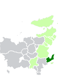
 Auratia (dark green) and the Euclean Community (light green) in Euclea. | |
| Capital | Cienflores Puerto del Rey (Judicial) |
| Largest city | Villadad |
| Official languages | Auratian |
| Recognised regional languages | Iustian |
| Ethnic groups | 67% Oratiano 21% Iustian 5% Etrurian 3% Gaullican 2% Badawiyan 1% Bahian 1% other |
| Religion | 98% Solarian Catholic 2% other |
| Demonym(s) | Auratian |
| Government | Federal parliamentary constitutional republic |
| Enrique Santos Dominguez | |
| Germán del Caserío | |
| Piedro Probi | |
| Víctor Paz | |
| David de Salomón | |
| Legislature | Parliament |
| Senate | |
| Assembly of the People | |
| Establishment | |
• Monarchy | 8 August 1573 |
• Republic | 13 January 1820 |
| 28 June 1868 | |
| Area | |
• Total | 240,886 km2 (93,007 sq mi) |
• Water (%) | 7.02 |
| Population | |
• 2016 estimate | |
• 2010 census | |
• Density | 137.1/km2 (355.1/sq mi) |
| GDP (nominal) | 2016 estimate |
• Total | |
• Per capita | $24,840 |
| Gini (2016) | low |
| HDI | high |
| Date format | dd.mm.yyyy |
| Driving side | right |
| Calling code | +71 |
| Internet TLD | .au |
Auratia (/ɔːˈreɪʃə/, Auratian: Oratia /oratja/), officially the Commonwealth of Auratian Catholic States (Auratian: la Mancomunidad de los Estados Católicos Oratianos), is a country comprised of eight states and one federal district located on the Auratian Penninsula in southern Euclea. It borders Gaullica to the northwest, Etruria to the southwest, the Sea of Assonaire to the north, and shares a maritime boundary with Emessa and Montecara to the south. The nation spans over 220,886 km2 and has an estimated population of roughly 33,020,000 people.
The Auratian Peninsula was first occupied by Tenic-speaking tribes who were subsequently conquered by and integrated into the Solarian Empire by 100 BC. The peninsula's position proved useful for the empire, serving as a jumping-off point for campaigns into central and northern Euclea and Coius. The Auratians were quick adapters of the Solarian Catholic Church, which still holds considerably sway in Auratian society today. After the fall of the Solarian Empire, the Auratian Peninsula was absorbed into the Verliquoian Empire, and the pensinsula was the focus of various invasion attempts by the Tagamics and Irfanic Heavenly Kingdom. By the turn of the millenium, the Auratian princes grew increasingly hostile towards Verliquoian rule, and many Auratian princes abrogated their feudal agreements with the Verliquoian emporers and broke away from Verliquoian rule. For the next five hundred years the peninsula was ruled by a loose, mostly leaderless confederacy of princedom, though the region was still mostly dominated by Verliquoian and later Gaullican political actors. It was during this period that two distinct linguistic identities formed: the Auratian-speaking Oratianos and the Iustians. Ever wary of the Iustians, various Oratiano princes signed the Compact of the Three Churches and formally created the Kingdom of Auratia, while the Iustians created the Kingdom of Iustia.
The Auratian Kingdom and the neighbouring Iustian Kingdom were key players in the conquest and colonization of Asteria Superior in the 16th century, though almost all of the kingdoms' territorial possessions were lost to Gaullica. Discontent towards the monarchs of Auratia brewed quickly, compounded by ravenous famines that swept over the kingdom in the later 18th century into the 19th century. Anti-monarchist sentiment culminated in the Alzamiento uprising led by Doctor Pablo Obrador. The Alzamiento culminated in the overthrow of Christian X, the last king of Auratia, and the signing of the Constitution of Auratia and ascention of republicanism on Ascension Day on 13 January 1820. The Kingdom of Iustia would continue to exist, constituting a serious threat to the newly-found republic. The thirty-one-year-long War for Auratian Unification culminated in a victory for Auratia, and the Kingdom of Iustia was subsequently dissolved and its territroy absorbed into Auratia's states. During the Great War, the country was briefly taken over by the September Clan, a military junta, which was ousted during the Rose Revolution in 1936.
Auratia is officially a federal republic and representative democracy. Its traditional capital is Puerto del Rey, while its administrative capital is the planned city of Cienflores. The country is a member of the Euclean Community, the Community of Nations, the Aurean Forum, and the International Trade Organization. Auratia is a major tourist destination celebrated for its cultural wealth and history in art, literature, music, and architecture.
Etymology
"Auratia" comes from Solarian Terra Aurāta, literally "gilded land." Early Solarian traders who entered the Auratian Peninsula observed that Tenic tribe chieftans often bedecked their garments with gold. These traders brought back tall tales promising gold in the peninsula, and the potential for gold mining was the impetus of many military campaigns in the Auratian Penninsula. Ironically, little gold was found, as most of the peninsula's extant mine quarries were dried up during the Iron Age. It would take one thousand years for a new source of gold to be discovered on the peninsula. A popular belief among the Solarians was that, if translated and properly understood, ancient Tenic texts or etchings may lay bare the location of vast troves of gold. There is no indication that the Tenics withheld such information in their texts, however.
History
Prehistory and Solarian Empire
Tools and artifacts from the Paleolithic Era indicate that early humans have been present in the Auratian Peninsula for at least 1.5 million years. Popular consensus among archaeologists holds that early humans crossed from Badawiya and into Euclea via the peninsula. Neanderthals, another hominid species, flourished in the peninsula and bred with Homo sapiens.
Verliquoian rule and independence
Warring Princedoms
Kingdom of Auratia and Colonial Period
Revolution and Republican Auratia
Unification
Great War, September Clan, and the Rose Revolution
Geography and climate
The Auratian Peninsula has been measured to be rougly 240,886 km2. The country's exact area is difficult to estimate owing to the hundreds of islets and reefs that line the nation's coast. Much of Auratia's coastline is jagged and rocky, with huge spiral rock formations along the country's eastern seabord. Most inland areas are dominated by long chains of rolling hills. Flatlands nestled in valleys or straths are not uncommon, however. The peninsula's inland soil is known for its exceptionally good tilth, and the inland states are the country's breadbasket
The terrain becomes much more mountaneous towards the border with Gaullica and Etruria, where the mountains form an end chain of the Etrurian Mountains. Mount Orico is the country's tallest mountain, measured to soar above 2,145 meters (7037 ft).
Many of the nation's largest cities sit on the Zatorra River—the largest river in Auratia—or its tributaries, including the nation's administrative capital Cienflores. Other historically important river is the Doro River.
Climate
Most of Auratia, particularly its coastal areas, boasts a Mediterranean climate characterized by dry summers and milder, wet winters. A steppe-like climate can be observed in deeper inland regions, as is the case in some parts of La Virtud, an inland state, with temperatures that vary depending on altitude.


