Geography of Glanodel: Difference between revisions
Jump to navigation
Jump to search
No edit summary |
No edit summary |
||
| (One intermediate revision by the same user not shown) | |||
| Line 3: | Line 3: | ||
| style="text-align:center;" colspan="2"|'''Geography of Glanodel''' | | style="text-align:center;" colspan="2"|'''Geography of Glanodel''' | ||
|- | |- | ||
| style="text-align:center;" colspan="2"| [[Image:Glanodel-Div_Geo_Map.png| | | style="text-align:center;" colspan="2"| [[Image:Glanodel-Div_Geo_Map.png|250px]] | ||
|- | |- | ||
|| '''{{wp|Continent}}''' | || '''{{wp|Continent}}''' | ||
| Line 63: | Line 63: | ||
==Terrain== | ==Terrain== | ||
With over 60% of the country being forest or woodland, Glanodel is heavily forested. Farmland constitutes only 8% of land use. There are 18,681 lakes and waterways throughout Glanodel, constituting 42,538 km<sup>2</sup> of water area. The relatively high number of lakes in Glanodel, a common feature of far northern, Asuran countries, is attributed to the stripping of an irregular mantle of {{wp|weathering|weathered rock}} by {{wp|glacier erosion}}. This plethora of waterways is used for {{wp|water power}} plants. | <!--With over 60% of the country being forest or woodland, Glanodel is heavily forested. Farmland constitutes only 8% of land use. There are 18,681 lakes and waterways throughout Glanodel, constituting 42,538 km<sup>2</sup> of water area. The relatively high number of lakes in Glanodel, a common feature of far northern, Asuran countries, is attributed to the stripping of an irregular mantle of {{wp|weathering|weathered rock}} by {{wp|glacier erosion}}. This plethora of waterways is used for {{wp|water power}} plants. | ||
Western Glanodel are dominated by vast tracts of hilly and mountainous land. Its southern boundary is generally identified with the appearance of natural grown {{wp|oaks}} extending northward from the south and the region's well developed valleys that act as transition zones for vegetation. {{wp|Till}} and {{wp|peat}} are the most common {{wp|soil types}} in these regions. | Western Glanodel are dominated by vast tracts of hilly and mountainous land. Its southern boundary is generally identified with the appearance of natural grown {{wp|oaks}} extending northward from the south and the region's well developed valleys that act as transition zones for vegetation. {{wp|Till}} and {{wp|peat}} are the most common {{wp|soil types}} in these regions. | ||
| Line 79: | Line 79: | ||
File:P1000290Jostedalsbreen.JPG| Askilgletscher (Askil Glacier) in northern Íssvegr | File:P1000290Jostedalsbreen.JPG| Askilgletscher (Askil Glacier) in northern Íssvegr | ||
File:957 Ørnsø øst.jpg| Vaatvollskovene (Vaatvoll's Forests) in central Villradäl | File:957 Ørnsø øst.jpg| Vaatvollskovene (Vaatvoll's Forests) in central Villradäl | ||
</gallery> | </gallery>--> | ||
==Political divisions== | ==Political divisions== | ||
===Cantons=== | <!--===Cantons=== | ||
Glanodel has 13 cantons (Glanish: ''kantons''), based on culture, geography, and history: Aldinnheim, Beinvollr, Eimivollr, Einnland, Einvigibiod, Feniland, Flódhgardr, Fogilundr, Fossland, Grœnnvollr, Hafland, Helloreg, Herfiligrbjodh, Hvalrbiodth, Ileinskali, Íssvegr, Jokulheim, Keledalr, Østbjorth, Særland, Særmark, Siwald, Sørland, Sumisetr, and Villradäl. These political divisions serve an important political and administrative purpose, as well as an important role for the citizenry's self-identification. Administratively, cantons are further divided into [[County|counties]] with 43 counties nationwide. | Glanodel has 13 cantons (Glanish: ''kantons''), based on culture, geography, and history: Aldinnheim, Beinvollr, Eimivollr, Einnland, Einvigibiod, Feniland, Flódhgardr, Fogilundr, Fossland, Grœnnvollr, Hafland, Helloreg, Herfiligrbjodh, Hvalrbiodth, Ileinskali, Íssvegr, Jokulheim, Keledalr, Østbjorth, Særland, Særmark, Siwald, Sørland, Sumisetr, and Villradäl. These political divisions serve an important political and administrative purpose, as well as an important role for the citizenry's self-identification. Administratively, cantons are further divided into [[County|counties]] with 43 counties nationwide. | ||
| Line 91: | Line 91: | ||
Each county is further divided into municipalities, the number of which varies from county to county. There is a total of 3,217 municipalities. | Each county is further divided into municipalities, the number of which varies from county to county. There is a total of 3,217 municipalities. | ||
The northern municipalities are often large in physical size but with low population densities, while southern municipalities, especially along the coast, tend to be more compact with significant population densities. | The northern municipalities are often large in physical size but with low population densities, while southern municipalities, especially along the coast, tend to be more compact with significant population densities.--> | ||
==Environment== | ==Environment== | ||
[[File:Cervus elaphus Luc Viatour 6.jpg|thumb|250px|right|Efforts to curb the rapid growth of the red deer population have resulted in it being the most frequently hunted animal in Glanodel.]] | <!--[[File:Cervus elaphus Luc Viatour 6.jpg|thumb|250px|right|Efforts to curb the rapid growth of the red deer population have resulted in it being the most frequently hunted animal in Glanodel.]] | ||
Environmental concerns in Glanodel are primarily focused around controlling {{wp|greenhouse gas}} emissions, industrial {{wp|pollution}} of the air and water, loss of habitat, damage to cold water {{wp|coral reefs}} from {{wp|fishing trawler|trawlers}}, and {{wp|salmon}} {{wp|aquaculture|fish farming}} threatening the wild salmon by spawning in the rivers, thereby diluting the local DNA. {{wp|Acid rain}} is also damaging lakes, rivers, and soils, especially in the southern cantons. | Environmental concerns in Glanodel are primarily focused around controlling {{wp|greenhouse gas}} emissions, industrial {{wp|pollution}} of the air and water, loss of habitat, damage to cold water {{wp|coral reefs}} from {{wp|fishing trawler|trawlers}}, and {{wp|salmon}} {{wp|aquaculture|fish farming}} threatening the wild salmon by spawning in the rivers, thereby diluting the local DNA. {{wp|Acid rain}} is also damaging lakes, rivers, and soils, especially in the southern cantons. | ||
| Line 183: | Line 183: | ||
}} | }} | ||
{{clear}} | {{clear}}--> | ||
==Biodiversity and ecology== | ==Biodiversity and ecology== | ||
[[File:Trillemarka langseterfjell.jpg|350px|thumbnail|right|Ásskov (Forest of the Gods) is one of the few remaining {{wp|old-growth forests}} in the world and is located on the west side of the island of Skaarup.]] | <!--[[File:Trillemarka langseterfjell.jpg|350px|thumbnail|right|Ásskov (Forest of the Gods) is one of the few remaining {{wp|old-growth forests}} in the world and is located on the west side of the island of Skaarup.]] | ||
Due to Glanodel's unique position geographically and wide, longitudinal range, the country's territory houses a wide variety of ecosystems and currently hosts approximately 60,000 different species both on land and in its waters (excluding bacteria and virus). The marine ecosystems of the Lhedwin Shelf, the {{wp|continental shelf}} which runs along the southern boundary of the Lhedwin's {{wp|maritime border}}, is considered highly productive. | Due to Glanodel's unique position geographically and wide, longitudinal range, the country's territory houses a wide variety of ecosystems and currently hosts approximately 60,000 different species both on land and in its waters (excluding bacteria and virus). The marine ecosystems of the Lhedwin Shelf, the {{wp|continental shelf}} which runs along the southern boundary of the Lhedwin's {{wp|maritime border}}, is considered highly productive. | ||
The total number of species include 18,000 species of {{wp|insects}} (probably 4,000 more species yet to be described), 20,000 species of {{wp|algae}}, 1,800 species of {{wp|lichen}}, 1,050 species of {{wp|mosses}}, 2,800 species of {{wp|vascular plants}}, up to 7,000 species of {{wp|fungi}}, 450 species of {{wp|birds}} (250 species nesting in Norway), 90 species of {{wp|mammals}}, 45 fresh-water species of fish, 150 salt-water species of fish, 1,000 species of fresh-water {{wp|invertebrates}} and 3,500 species of salt-water invertebrates. | The total number of species include 18,000 species of {{wp|insects}} (probably 4,000 more species yet to be described), 20,000 species of {{wp|algae}}, 1,800 species of {{wp|lichen}}, 1,050 species of {{wp|mosses}}, 2,800 species of {{wp|vascular plants}}, up to 7,000 species of {{wp|fungi}}, 450 species of {{wp|birds}} (250 species nesting in Norway), 90 species of {{wp|mammals}}, 45 fresh-water species of fish, 150 salt-water species of fish, 1,000 species of fresh-water {{wp|invertebrates}} and 3,500 species of salt-water invertebrates. | ||
Since 2002, the Environmental and Ecological Research Institute has maintained a "red list" encompassing around 2,986 species. 40 of these species are on a global list of endangered species, even if the Glanish population isn't considered endangered. Several of these species are fungi closely associated with the few remaining old-growth forests. About half of these species are listed as endangered or vulnerable as of 2006 such as the gray {{wp|wolf}}, the {{wp|Arctic fox}}, and the {{wp|pool frog}}. The {{wp|sperm whale}} is the largest predator in Glanish waters and the largest fish is the {{wp|basking shark}}. The largest predator on land is the {{wp|polar bear}} and the common {{wp|moose}} is the largest animal. | Since 2002, the Environmental and Ecological Research Institute has maintained a "red list" encompassing around 2,986 species. 40 of these species are on a global list of endangered species, even if the Glanish population isn't considered endangered. Several of these species are fungi closely associated with the few remaining old-growth forests. About half of these species are listed as endangered or vulnerable as of 2006 such as the gray {{wp|wolf}}, the {{wp|Arctic fox}}, and the {{wp|pool frog}}. The {{wp|sperm whale}} is the largest predator in Glanish waters and the largest fish is the {{wp|basking shark}}. The largest predator on land is the {{wp|polar bear}} and the common {{wp|moose}} is the largest animal.--> | ||
{{Template:Glanodel}} | {{Template:Glanodel}} | ||
Latest revision as of 21:29, 16 October 2022
| Geography of Glanodel | |

| |
| Continent | Asura |
| Subregion | Lhedwin |
| Area - total - water |
236,326 km2 42,538 km2 (18%) |
| Coastline | 5,700 km (3,500 mi) |
| Countries bordered | Navack 354 km |
| Highest point | Jokulpiggen, 2,501 m (8,205 ft) |
| Lowest point | Dalby, −1.91 m |
| Longest river | Pederså, 720 km (447.4mi) |
| Largest inland body of water | Vestr Sø 5,648 km2 (3,510 sq mi) |
| Land use - Arable land - Farmland - Other |
6.07% 0.91% 93.02% |
| Climate | Temperate to arctic |
| Terrain | Flat lowlands, forests, mountainous, tundra |
| Natural resources | Iron ore, copper, lead, zinc, gold, silver, tungsten, uranium, arsenic, feldspar, timber, hydropower |
| Natural hazards | Asuran windstorms, avalanche, ice flow, landslides, tsunamis |
| Environmental issues | Acid rain, eutrophication, soil degradation |
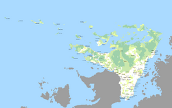
Glanodel is a country in Northern Asura encompassing the majority of the Northernmost territory of the Lhedwin Isles. Its only land border is with Navack to the southwest and is bordered by the Arctic Ocean to the north and the Lhedwin Channel to the east.
As part of the Lhedwin archipelago, Glanodel is considered a large, island nation. It has maritime borders with Aleia, Newrey, and Vynozhia. At 236,326 square kilometres (91,246 sq mi), Glanodel is the largest country in Lhedwin by land area. It is the sixth (or seventh) largest in Asura.
