Geography of Glanodel
Jump to navigation
Jump to search
| Geography of Glanodel | |

| |
| Continent | Asura |
| Subregion | Lhedwin |
| Area - total - water |
236,326 km2 42,538 km2 (18%) |
| Coastline | 5,700 km (3,500 mi) |
| Countries bordered | Navack 354 km |
| Highest point | Jokulpiggen, 2,501 m (8,205 ft) |
| Lowest point | Dalby, −1.91 m |
| Longest river | Pederså, 720 km (447.4mi) |
| Largest inland body of water | Vestr Sø 5,648 km2 (3,510 sq mi) |
| Land use - Arable land - Farmland - Other |
6.07% 0.91% 93.02% |
| Climate | Temperate to arctic |
| Terrain | Flat lowlands, forests, mountainous, tundra |
| Natural resources | Iron ore, copper, lead, zinc, gold, silver, tungsten, uranium, arsenic, feldspar, timber, hydropower |
| Natural hazards | Asuran windstorms, avalanche, ice flow, landslides, tsunamis |
| Environmental issues | Acid rain, eutrophication, soil degradation |
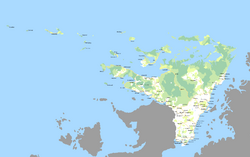
Glanodel is a country in Northern Asura encompassing the majority of the Northernmost territory of the Lhedwin Isles. Its only land border is with Navack to the southwest and is bordered by the Arctic Ocean to the north and the Lhedwin Channel to the east.
As part of the Lhedwin archipelago, Glanodel is considered a large, island nation. It has maritime borders with Aleia, Newrey, and Vynozhia. At 236,326 square kilometres (91,246 sq mi), Glanodel is the largest country in Lhedwin by land area. It is the sixth (or seventh) largest in Asura.
