Weranian Empire: Difference between revisions
Britbong64 (talk | contribs) (→Legacy) |
Britbong64 (talk | contribs) No edit summary |
||
| (5 intermediate revisions by 2 users not shown) | |||
| Line 22: | Line 22: | ||
|capital = [[Westbrücken]] | |capital = [[Westbrücken]] | ||
|common_languages = {{wp|German language|Weranian}}<br /> {{hidden|'''Local:'''|{{wp|Swahili language|Swahili}}, {{wp|Amharic|Talanzi}}, {{wp|Volta–Niger languages|North Bahian}}, {{wp|Arabic|Rahelian}}, {{wp|Zulu language|Kulo}}, {{wp|Berber languages|Tamazight}} ([[Bahia]]n colonies)<br/> | |common_languages = {{wp|German language|Weranian}}<br /> {{hidden|'''Local:'''|{{wp|Swahili language|Swahili}}, {{wp|Amharic|Talanzi}}, {{wp|Volta–Niger languages|North Bahian}}, {{wp|Arabic|Rahelian}}, {{wp|Zulu language|Kulo}}, {{wp|Berber languages|Tamazight}} ([[Bahia]]n colonies)<br/> | ||
{{wp|Thai language|Kasine}} and {{wp|Southern Thai language|Lower Kasi}}, {{wp|Mon language| | {{wp|Thai language|Kasine}} and {{wp|Southern Thai language|Lower Kasi}}, {{wp|Mon language|Nyaram}}, {{wp|Vietnamese language|Nainese}}, {{wp|Isan language|Makhao}}, {{wp|Khmer language|Svai}}, {{wp|Karen people|Kayin}}, {{wp|Mandarin Chinese|Shangean}} ([[Southeast Coius]]<br/>{{wp|Papuan languages|Sublustian}}, {{wp|Samoan language|Tutuan}} (Sublustria) |style=font-size:100%;padding:0.25em 0 0; |headerstyle=text-align:left;font-weight:normal;}} | ||
}} | }} | ||
The '''Weranian colonial empire''' (''{{wp|German language|Weranian}}'': '''Ostischer Kolonialreich''') comprised the overseas colonies, protectorates, concessions and trust territories that came under Weranian rule during the 19th century. The Weranian Empire comprised of four parts - north Bahia, central Bahia, Southeast Coius and Sublustria. The empire covered modern day territories such as [[Maucha]], [[Yemet]], [[Behera]], [[Nainan]], [[Kuthina]], [[Siamat]] and [[Charlotte Island]]. At its height in 1935 the Weranian Empire ruled over 80 million people across two continents. | The '''Weranian colonial empire''' (''{{wp|German language|Weranian}}'': '''Ostischer Kolonialreich''') comprised the overseas colonies, protectorates, concessions and trust territories that came under Weranian rule during the 19th century. The Weranian Empire comprised of four parts - north Bahia, central Bahia, Southeast Coius and Sublustria. The empire covered modern day territories such as [[Maucha]], [[Yemet]], [[Behera]], [[Nainan]], [[Kuthina]], [[Siamat]] and [[Charlotte Island]]. At its height in 1935 the Weranian Empire ruled over 80 million people across two continents. | ||
| Line 33: | Line 33: | ||
==Origins== | ==Origins== | ||
==Acquisition of colonies== | ==Acquisition of colonies== | ||
==End of the | ==End of the colonial empire== | ||
==Administration and colonial policies== | ==Administration and colonial policies== | ||
===Colonial governments=== | ===Colonial governments=== | ||
Initially, Weranian colonies were under the jurisdiction of the Weranian navy, with the Weranian Ministry of the Marine appointing colonial governors and being responsible for their administration. In 1880 the government of Joachim Schwarzenberg created the Ministry of Colonies which subsequently launched a standardisation of Weranian colonies. Directly owned colonies were named ''kommissariat''s with their personnel recruited from the metropole and governed by a ''kommissar'' appointed by the central government. Protectorates known as ''schutzgebiete'' were governed through a representative of the Weranian government known as a ''Bewohner-vorgesetzter'' (resident-supervisor). Another reorganisation in 1884 placed Weranian colonies into several colonial federations, known as High Commissariats (''Oberkommissariat'') led by a High Commissar (''Oberkommissar'') centralising colonial administrations. | |||
===Colonial population=== | ===Colonial population=== | ||
===Medicine and science=== | ===Medicine and science=== | ||
===Symbols=== | ===Symbols=== | ||
==Colonies== | |||
==Territories== | |||
===Colonies=== | |||
{| class="wikitable" | |||
|- | |||
! Territory !! Period !! Current countries | |||
|- | |||
| {{flagicon_image|Fla of colonial north Bahia.png}} [[High Commissariat of the Bahian Coast]] | |||
*tba | |||
*tba | |||
||1865-1953 | |||
|| | |||
*tba | |||
*tba | |||
|- | |||
| {{flagicon_image|Flag of Weranian East Coius.png}} [[High Commissariat of the Coral Sea]] | |||
*{{flagicon_image|NiehFlag.png}} [[Kühsor]] | |||
*{{flagicon_image|NaiMandat.png}} [[Nainan]] | |||
||1877-1953 | |||
|| | |||
*{{flag|Kuthina}} | |||
*{{flag|Nainan}} | |||
|- | |||
| {{flagicon_image|Tabora colonial flag.png}} [[Silberküste|High Commissariat of the Silver Coast]] | |||
||1870-1953 | |||
||{{flag|Maucha}} | |||
|- | |||
| {{flagicon_image|Flag of Weranian Sublustria.png}} [[High Commissariat of the Sublustrian Sea]] | |||
*tba | |||
*{{flagicon_image|Colonial Charlotte Island flag.png}} [[Charlotte Island]] | |||
||1884-1954 | |||
|| | |||
*tba | |||
*{{flagicon_image|Flag of the Charlotte Island.png}} [[Charlotte Island]] | |||
|} | |||
===CN Trust Territories=== | |||
{| class="wikitable" | |||
|- | |||
! Territory !! Period !! Current countries | |||
|- | |||
| {{flagicon_image|Flag of colonial Behara.png}} [[Weranian Behera]] | |||
||1935-1953 | |||
||{{flag|Behera}} | |||
|- | |||
| {{flagicon_image|Obergond Flag.png}} [[Obergond]] | |||
||1935-1953 | |||
||{{flag|Yemet}} | |||
|- | |||
| {{flagicon_image|Flag of colonial Siamat.png}} [[Weranian Siamat]] | |||
||1935-1945 | |||
||{{flag|Siamat}} | |||
|} | |||
==Legacy== | ==Legacy== | ||
{{Template:Werania}} | {{Template:Werania}} | ||
[[ | [[category:History of Werania]] | ||
Latest revision as of 01:10, 17 April 2022
Weranian colonial empire Ostischer Kolonialreich | |
|---|---|
| 1864–1953 | |
|
Left: The flag of Werania. Right: The colonial ensign of Werania | |

| |
| Status | Colonial empire |
| Capital | Westbrücken |
| Common languages | Weranian Local: Swahili, Talanzi, North Bahian, Rahelian, Kulo, Tamazight (Bahian colonies) Sublustian, Tutuan (Sublustria) |
| History | |
• Establishment of Silberküste | 1864 |
• Kasine Expedition | 1877 |
• Creation of the trust territories | 1934 |
• Disestablished | 1953 |
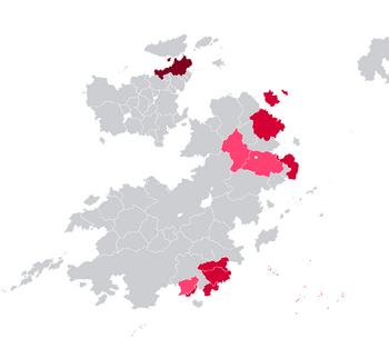
The Weranian colonial empire (Weranian: Ostischer Kolonialreich) comprised the overseas colonies, protectorates, concessions and trust territories that came under Weranian rule during the 19th century. The Weranian Empire comprised of four parts - north Bahia, central Bahia, Southeast Coius and Sublustria. The empire covered modern day territories such as Maucha, Yemet, Behera, Nainan, Kuthina, Siamat and Charlotte Island. At its height in 1935 the Weranian Empire ruled over 80 million people across two continents.
The Weranian empire arouse out of the failure of further expansion into Euclea following the War of the Triple Alliance, a rivalry with other colonial powers such as Gaullica, Estmere and Etruria for raw resources and support for the civilising mission. The Weranian empire would as such attempt to spread its language and religion to colonised regions. The empire provided prestige, manpower and raw materials to Werania enabling it to become confirmed as one of the Euclean great powers.
In some places such as southeast Coius Werania relied more on client leaders through protectorates to govern the region whilst in central Bahia it administrated the region in a more centralised manner encouraging settler colonialism. In the creation of the empire the Weranian government used the civilising mission rhetoric to justify often brutal atrocities to native populations.
Following the Great War Werania was awarded former Gaullican colonies as trust territories reaching its greatest territorial zenith. However the empire would soon be caught in a brutal colonial war in central Bahia and following the Kirenian-Weranian War moved towards decolonisation. By the mid 1950s Werania had overseen the majority of former colonies either becoming loosely allied sovereign states or becoming overseas territories of Werania.
Origins
Acquisition of colonies
End of the colonial empire
Administration and colonial policies
Colonial governments
Initially, Weranian colonies were under the jurisdiction of the Weranian navy, with the Weranian Ministry of the Marine appointing colonial governors and being responsible for their administration. In 1880 the government of Joachim Schwarzenberg created the Ministry of Colonies which subsequently launched a standardisation of Weranian colonies. Directly owned colonies were named kommissariats with their personnel recruited from the metropole and governed by a kommissar appointed by the central government. Protectorates known as schutzgebiete were governed through a representative of the Weranian government known as a Bewohner-vorgesetzter (resident-supervisor). Another reorganisation in 1884 placed Weranian colonies into several colonial federations, known as High Commissariats (Oberkommissariat) led by a High Commissar (Oberkommissar) centralising colonial administrations.
Colonial population
Medicine and science
Symbols
Territories
Colonies
| Territory | Period | Current countries |
|---|---|---|
|
1865-1953 |
|
| 1877-1953 | ||
| 1870-1953 | ||
|
1884-1954 |
|
CN Trust Territories
| Territory | Period | Current countries |
|---|---|---|
| 1935-1953 | ||
| 1935-1953 | ||
| 1935-1945 |


