Garambura: Difference between revisions
No edit summary |
No edit summary |
||
| Line 111: | Line 111: | ||
|population_density_rank = | |population_density_rank = | ||
|nummembers = <!--An alternative to population for micronation--> | |nummembers = <!--An alternative to population for micronation--> | ||
|GDP_PPP = $ | |GDP_PPP = $55.8 billion | ||
|GDP_PPP_rank = | |GDP_PPP_rank = | ||
|GDP_PPP_year = 2019 | |GDP_PPP_year = 2019 | ||
|GDP_PPP_per_capita = $ | |GDP_PPP_per_capita = $6,462 | ||
|GDP_PPP_per_capita_rank = | |GDP_PPP_per_capita_rank = | ||
|GDP_nominal = $ | |GDP_nominal = $33.5 billion | ||
|GDP_nominal_rank = | |GDP_nominal_rank = | ||
|GDP_nominal_year = 2019 | |GDP_nominal_year = 2019 | ||
|GDP_nominal_per_capita = $ | |GDP_nominal_per_capita = $3,884 | ||
|GDP_nominal_per_capita_rank = | |GDP_nominal_per_capita_rank = | ||
|Gini = 29.7 | |Gini = 29.7 | ||
Revision as of 15:07, 30 December 2019
Republic of Garambura | |
|---|---|
| Motto: "Kumakomo nekudzoka" ("To the mountains and back") | |
| Anthem: "Vanhu veGarambura, simuka" (Estmerish: People of Garambura, arise") | |
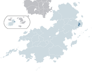
 Garambura (dark blue) located within Coius (light blue). | |
 | |
| Capital |
|
| Largest city | |
| Official languages | 6 languages: |
| Ethnic groups (2014) |
|
| Religion (2014) | |
| Demonym(s) | Garamburan |
| Government | Unitary presidential republic |
• President | Muzukuru Chiyangwa |
• Vice President | Zivai Mushohwe |
| Legislature | Parliament |
| Congress | |
| Imbayaka | |
| Independence from Rwizikuru | |
• Declared | 16 February 1969 |
• Republic | 30 April 1969 |
• Admitted to the CoN | 5 March 1971 |
• Admitted to the CBS | 17 November 1979 |
• Current constitution | 3 June 2011 |
| Population | |
• 2019 estimate | 8,635,881 |
• 2014 census | 8,401,266 |
| GDP (PPP) | 2019 estimate |
• Total | $55.8 billion |
• Per capita | $6,462 |
| GDP (nominal) | 2019 estimate |
• Total | $33.5 billion |
• Per capita | $3,884 |
| Gini (2014) | low |
| HDI (2014) | medium |
| Currency | Garamburan denier (GSH) |
| Date format | dd-mm-yyyy |
| Driving side | left |
| Calling code | +181 |
| ISO 3166 code | GAR |
| Internet TLD | .gb |
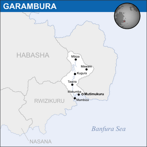
Garambura (/'gæræmbʊra:/), officially the Republic of Garambura, is a country in eastern Bahia, located on the continent of Coius. The River Gonda runs up most of the country. It borders Habasha to the north and Rwizikuru to the west. The country's capital and second-largest city is Mutimukuru, while the country's largest is Mambiza. With almost 9 million people, Garambura is one of the smallest countries in Coius and Bahia, and is also one of the poorest, with a nominal GDP per capita of only $1,884. The country has six official languages, with veRwizi, Sisulu and Gaullican being the most prevalent.
Since the 11th century, Garambura was historically under the subjugation of the vast veRwizi Empire, who hailed from modern-day Rwizikuru. First colonial contact came when the Gaullicans established a trading outpost called Saint-Germain (modern-day Mambiza) in 1656. The Gaullicans eventually worked their way inland through colonial conquest and by 1840 the entirety of Garambura was part of the Gaullican Terre-Noire colony. Mambiza served as a major stopover for Gaullican merchants on their way to Xiaodong and Jindao, and so the city grew quickly under colonial rule. When Raphael Duclerque's national functionalists took power in Gaullica in 1919, cultural repression began spiking on the island as previous colonial ministers were replaced with national functionalists. Many natives were conscripted into the Gaullican army and fought heavily on the Bahian front of the war. When Gaullica lost the war, Garambura was transferred to Estmere as East Riziland, a subdivision of the larger Riziland.
Garambura got its independence from Estmere under the Rwizikuru Republic, but growing authoritarianism and the declaration of Izibongo Ngonidzashe that he would become an absolute monarch spearheaded calls for Garamburan independence. The Garamburan National Front formed in 1968 under Kuziva Midzi as a guerrilla paramilitary, and Garambura unilaterally declared its independence on February 16, 1969, whilst Rwizikuru was fighting Nasana over the region of Yekumavirira. The war was swift as the guerrillas won a major battle at the Battle of Mambiza on April 18, forcing the Rwizikurans to retreat. Surrounded on both sides, Izibongo met with Midzi on April 30, 1969, in Port Fitzhubert, and agreed to fully recognise Garamburan independence. Izibongo referred to the Garamburans as "traitors" and relations with Rwizikuru did not recover until Kupakwashe Ngonidzashe came to power in 1979.
In the modern day, Garambura is a member of the ICD, CoN, the ITO and GIFA. Despite the country's fractured past, it scores well on democracy and freedom indexes.
Etymology
The name "Garambura" originates as a corrupted portmanteau of the veRwizi words Garama - meaning "life" or "lively" - and rakakura, meaning "vast". The country's official name is the Republic of Garambura, which was adopted upon independence in 1969. Unlike many other colonised nations, its etymology stems from its native language. Under Gaullican colonisation, it was referred to as Terre-Noire, Gaullican for "black land", reportedly named after the soil of the Gonda Delta, now referred to as Gonda black earth, but the legitimacy of this claim is debated, with other historians claiming it was named after its people.
History
Early period
Archaeological evidence uncovered in Garambura suggests that civilised humans had inhabited the area since at least 2000 BC. Stone tools, fossilised bones and cuttings on animal bones suggest that foragers made up the majority of an early Garamburan populace. However, some archaeologists suggest these marks could have been made during the excavation process, and attribute the first humans in Garambura to be a people who inhabited a small area near modern-day Mbiza, known simply as the Vanhu peoples.
The first permanent settlers in Garambura appeared some time between 800 and 400 BC, and settled areas around the Gonda Delta, utilising the region's fertility to begin small settlements across the river. Slash and burn agriculture was used extensively and affected the early biodiversity of the region, both flora and fauna. These small settlements would exist almost independent of any other Bahian polities of the time, and the area was well-developed for pre-colonial Bahia, transforming into a loose confederacy of tribes by 800 AD, following fetishist beliefs. When the Irfanic Founagé Dominion of Heaven formed towards the end of the 9th-century, the tribesmen of early Garambura feared their traditional beliefs would be forcefully stamped out. The towns briefly united into the Akatendeka Confederacy, but were swiftly defeated by the rising Hourege system in Bahia, which would heavily influence Garamburan society after the fall of Akatendeka.
After the emergence of Hourege, many villages began to be settled up and down the Gonda River, mainly by the veRwizi and Sisulu populace, who had diverged into separate areas of the country by this point. The villages were dominated by the Hourege system, but the Banfuri coastal cities dominated, with Mutimukuru emerging to be one of the larger Hourege settlements in Bahia. Traditional society flourished in Garambura under the Houragic golden age, with the Gonda Delta settlements and Mutimukuru seeing increases in size as Pan-Bahian trade increased. The dominance of Hourege was solidifed when the area was conquered by the veRwizi Empire in the 12th century.
veRwizi Empire
The empire's rule was generally quite lax and the area did not suffer any real direct oppression. Under the golden age of the veRwizi Empire, around the 1400s, pan-Bahian trade flourished and the coastal cities of Garambura attracted merchants and tradesmen for their attractive deltas and natural harbours. The start of major trade in the area caused a massive divide between the veRwizi people of the coast, now wealthy and living lives more akin to middle-class veRwizi in Rwizikuru, and the Sisulu and Njinji peoples inland, who felt neglected by the empire's rule. They revolted in 1636, losing the revolt itself but contributing as a whole to the collapse of the empire in the 1650s, after which a Sisulu-Njinji tribal confederacy invaded the veRwizi portions of Garambura, suing them for land in the north and isolating them to the direct coast.
Geography
Garambura is a country in eastern Bahia, with a southern coast on the Banfura Sea. It borders Tabora to the east, Habasha to the north and Rwizikuru to the west. Garambura is a comparatively flat country, with its tallest point lying at only 512m above sea level. The Gonda river stretches the length of the country, forming natural phenomena such as the expansive Gonda Delta and the Gonda Valley.
Geology
Garambura is known for its diverse geology and mineral resources, being a producer of minerals such as coal, copper, iron ore and tin, as well as having large deposits of valuable resources like diamonds and gold, the latter of which the country possesses the largest deposits in Bahia.
Climate
Much of Garambura is subject to a tropical climate with some large-scale local variations. Towards the east of the country, away from the Gonda, the climate is known for its heat and aridity, whilst the western portion of the country nearer to the Gonda is known for its vast rainforests, its humidity, mild temperatures and large amounts of rainfall. The country rarely experiences prolonged drought periods, although the city of Maware in the east has been known for its longer-than-usual dry periods. However, schemes are beginning to be put in place that transfer water from the river Gonda into reservoirs in the Lusulu Village National Park, some 20 miles south of Maware.
Flora and fauna
Garambura is home to an extremely diverse selection of local flora and fauna, with most of the country covered in tropical rainforests and inhabited by numerous species of animal, many of which are unique to the area. Many nature conservationist organisations estimate there are over 500 unique species of mammal, reptile and amphibious creatures in Garambura, and the country works closely with these organisations to preserve the wildlife. An estimated 85% of the country is covered by rainforest, down from around 92% in 1979, which has caused some groups to raise concern for deforestation in Garambura, much of which is illegal and untracked by the government.
Environmental issues

In recent years, the government of Garambura have begun numerous programs in order to prevent the degradation of the country's environment, particularly its rainforests. Illegal deforestation is a problem in the country, especially in the north and east, where settlements and scarce and illegal foresters can conduct slash and burn techniques on vast swathes of the forest. In 2013 especially conservationist efforts for wildlife spiked up significantly when the Banfura ray was declared extinct, having been targeted by fisheries along the south coast for years.


