Geography of Glanodel
| Geography of Glanodel | |

| |
| Continent | Asura |
| Subregion | Lhedwin |
| Area - total - water |
236,326 km2 42,538 km2 (18%) |
| Coastline | 5,700 km (3,500 mi) |
| Countries bordered | Navack 354 km |
| Highest point | Jokulpiggen, 2,501 m (8,205 ft) |
| Lowest point | Dalby, −1.91 m |
| Longest river | Pederså, 720 km (447.4mi) |
| Largest inland body of water | Vestr Sø 5,648 km2 (3,510 sq mi) |
| Land use - Arable land - Farmland - Other |
6.07% 0.91% 93.02% |
| Climate | Temperate to arctic |
| Terrain | Flat lowlands, forests, mountainous, tundra |
| Natural resources | Iron ore, copper, lead, zinc, gold, silver, tungsten, uranium, arsenic, feldspar, timber, hydropower |
| Natural hazards | Asuran windstorms, avalanche, ice flow, landslides, tsunamis |
| Environmental issues | Acid rain, eutrophication, soil degradation |
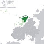
Glanodel is a country in Northern Asura encompassing the majority of the Northernmost territory of the Lhedwin Isles. Its only land border is with Navack to the southwest and is bordered by the Arctic Ocean to the north and the Lhedwin Channel to the east.
As part of the Lhedwin archipelago, Glanodel is considered a large, island nation. It has maritime borders with Aleia, Newrey, and Vynozhia. At 236,326 square kilometres (91,246 sq mi), Glanodel is the largest country in Lhedwin by land area. It is the sixth (or seventh) largest in Asura.
Terrain
With over 60% of the country being forest or woodland, Glanodel is heavily forested. Farmland constitutes only 8% of land use. There are 18,681 lakes and waterways throughout Glanodel, constituting 42,538 km2 of water area. The relatively high number of lakes in Glanodel, a common feature of far northern, Asuran countries, is attributed to the stripping of an irregular mantle of weathered rock by glacier erosion. This plethora of waterways is used for water power plants.
Western Glanodel are dominated by vast tracts of hilly and mountainous land. Its southern boundary is generally identified with the appearance of natural grown oaks extending northward from the south and the region's well developed valleys that act as transition zones for vegetation. Till and peat are the most common soil types in these regions.
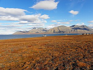
Northeastern and Central Glanodel has been heavily glaciated and consists of mostly high plateaus and rugged mountains broken by fertile valleys along with small, scattered plains and coastlines deeply indented by fjords. These regions are dominated by arctic tundra. Some regions experience frozen ground all-year in the higher mountain areas. Glaciers are also a common sight in the far northern regions. Boreal forests constitute most of this region's southern and western boundaries.
Eastern and southern central Glanodel is almost entirely lowlands. Often seen as the heart of Glanodel, these regions hold numerous areas of fertile soils suitable for agriculture. Prior to agricultural expansion, these regions were dominated by maples, oak, ashes, and common hazel, while areas with poorer quality soil, particularly hilly terrain, are still dominated by pine and spruce. Southernmost Glanodel contains a varied landscape with both plains and hilly terrain.
The plains of Feniland and Siwald make up 18% of the country's cultivated lands and are its main agricultural landscape. Productivity is close to that of Asuran nations further south. Most of Glanodel's biodiversity exists within its southern regions. Eimivollr and Trvetland are Glanodel's largest islands, located just off it's northern coasts. Much like the rest of the Glanish island territory, they differ in composition from the rest of Glanodel, being made up of mostly limestone and marl with alvar vegetation covering most the island's soils. Uvland, the island off the coast of Særland has rare land formations absent from most of mainland Glanodel such as: active cliffs, sea stacks called rauks, and large, natural cave systems.
- Physical geography
Political divisions
Cantons
Glanodel has 13 cantons (Glanish: kantons), based on culture, geography, and history: Aldinnheim, Beinvollr, Eimivollr, Einnland, Einvigibiod, Feniland, Flódhgardr, Fogilundr, Fossland, Grœnnvollr, Hafland, Helloreg, Herfiligrbjodh, Hvalrbiodth, Ileinskali, Íssvegr, Jokulheim, Keledalr, Østbjorth, Særland, Særmark, Siwald, Sørland, Sumisetr, and Villradäl. These political divisions serve an important political and administrative purpose, as well as an important role for the citizenry's self-identification. Administratively, cantons are further divided into counties with 43 counties nationwide.
Municipalities
Each county is further divided into municipalities, the number of which varies from county to county. There is a total of 3,217 municipalities.
The northern municipalities are often large in physical size but with low population densities, while southern municipalities, especially along the coast, tend to be more compact with significant population densities.
Environment
Environmental concerns in Glanodel are primarily focused around controlling greenhouse gas emissions, industrial pollution of the air and water, loss of habitat, damage to cold water coral reefs from trawlers, and salmon fish farming threatening the wild salmon by spawning in the rivers, thereby diluting the local DNA. Acid rain is also damaging lakes, rivers, and soils, especially in the southern cantons.
Another concern is a possible increase in extreme weather. Climate models have predicted an increase in precipitation, especially in areas which already experience high precipitation. These models also predict more episodes of heavy precipitation in short time spans, which could lead to an increase in landslides and local floods. Winters will most likely become significantly milder and sea ice covers in the Arctic Ocean which would threaten polar bear survival. Terrestrial and aquatic species are expected to migrate northward due to shrinking habitats.
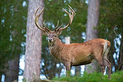
Consequences of these environmental concerns are already observable through migratory birds arriving earlier, trees coming into leaf earlier, as well as a growing red deer population spreading northwards and eastwards, resulting in the first hunting season with more red deer (34,900) shot than moose in 2010.
Glens are statistically the most worried about the effects of global warming, even though Glanodel is among the countries expected to be least negatively affected by global warming, with some possible gains.
Natural hazards
- Asuran windstorms with hurricane strength wind speed along the coast and in the mountains are not uncommon. For centuries, one out of four males in coastal communities were lost at sea.
- Avalanche and ice flow on steep slopes, especially in the northern part of the country and in mountain areas, have resulted in deaths.
- Landslides have, on occasion, killed people, mostly in areas with soil rich in marine clay.
- Tsunamis caused by parts of mountains (rockslide) falling into fjords or lakes, have killed people.
Climate
| Aakirkeby | ||||||||||||||||||||||||||||||||||||||||||||||||||||||||||||
|---|---|---|---|---|---|---|---|---|---|---|---|---|---|---|---|---|---|---|---|---|---|---|---|---|---|---|---|---|---|---|---|---|---|---|---|---|---|---|---|---|---|---|---|---|---|---|---|---|---|---|---|---|---|---|---|---|---|---|---|---|
| Climate chart (explanation) | ||||||||||||||||||||||||||||||||||||||||||||||||||||||||||||
| ||||||||||||||||||||||||||||||||||||||||||||||||||||||||||||
| ||||||||||||||||||||||||||||||||||||||||||||||||||||||||||||
| Broskov | ||||||||||||||||||||||||||||||||||||||||||||||||||||||||||||
|---|---|---|---|---|---|---|---|---|---|---|---|---|---|---|---|---|---|---|---|---|---|---|---|---|---|---|---|---|---|---|---|---|---|---|---|---|---|---|---|---|---|---|---|---|---|---|---|---|---|---|---|---|---|---|---|---|---|---|---|---|
| Climate chart (explanation) | ||||||||||||||||||||||||||||||||||||||||||||||||||||||||||||
| ||||||||||||||||||||||||||||||||||||||||||||||||||||||||||||
| ||||||||||||||||||||||||||||||||||||||||||||||||||||||||||||
| Graylund | ||||||||||||||||||||||||||||||||||||||||||||||||||||||||||||
|---|---|---|---|---|---|---|---|---|---|---|---|---|---|---|---|---|---|---|---|---|---|---|---|---|---|---|---|---|---|---|---|---|---|---|---|---|---|---|---|---|---|---|---|---|---|---|---|---|---|---|---|---|---|---|---|---|---|---|---|---|
| Climate chart (explanation) | ||||||||||||||||||||||||||||||||||||||||||||||||||||||||||||
| ||||||||||||||||||||||||||||||||||||||||||||||||||||||||||||
| ||||||||||||||||||||||||||||||||||||||||||||||||||||||||||||
| Vænholm | ||||||||||||||||||||||||||||||||||||||||||||||||||||||||||||
|---|---|---|---|---|---|---|---|---|---|---|---|---|---|---|---|---|---|---|---|---|---|---|---|---|---|---|---|---|---|---|---|---|---|---|---|---|---|---|---|---|---|---|---|---|---|---|---|---|---|---|---|---|---|---|---|---|---|---|---|---|
| Climate chart (explanation) | ||||||||||||||||||||||||||||||||||||||||||||||||||||||||||||
| ||||||||||||||||||||||||||||||||||||||||||||||||||||||||||||
| ||||||||||||||||||||||||||||||||||||||||||||||||||||||||||||
Biodiversity and ecology

Due to Glanodel's unique position geographically and wide, longitudinal range, the country's territory houses a wide variety of ecosystems and currently hosts approximately 60,000 different species both on land and in its waters (excluding bacteria and virus). The marine ecosystems of the Lhedwin Shelf, the continental shelf which runs along the southern boundary of the Lhedwin's maritime border, is considered highly productive.
The total number of species include 18,000 species of insects (probably 4,000 more species yet to be described), 20,000 species of algae, 1,800 species of lichen, 1,050 species of mosses, 2,800 species of vascular plants, up to 7,000 species of fungi, 450 species of birds (250 species nesting in Norway), 90 species of mammals, 45 fresh-water species of fish, 150 salt-water species of fish, 1,000 species of fresh-water invertebrates and 3,500 species of salt-water invertebrates.
Since 2002, the Environmental and Ecological Research Institute has maintained a "red list" encompassing around 2,986 species. 40 of these species are on a global list of endangered species, even if the Glanish population isn't considered endangered. Several of these species are fungi closely associated with the few remaining old-growth forests. About half of these species are listed as endangered or vulnerable as of 2006 such as the gray wolf, the Arctic fox, and the pool frog. The sperm whale is the largest predator in Glanish waters and the largest fish is the basking shark. The largest predator on land is the polar bear and the common moose is the largest animal.


