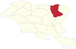
Arxaþ Region
Arxaþ | |
|---|---|
 | |
| Country | Gylias |
| Capital | Xakalen |
| Area | |
| • Total | 105,906 km2 (40,891 sq mi) |
| Population (2020) | |
| • Total | 878,820 |
| • Density | 8.3/km2 (21/sq mi) |
| Demonym | Arxans |
Arxaþ (abbreviated AR) is a region of Gylias. Located in the north-east, it borders Cacerta (Molise) to the north, Gerşyr to the west, Envadra and Nezyál to the south, and Alţira to the east. Its capital is Xakalen.
The region was part of Alscia, which is reflected in its flag.
Geography
Northern Arxaþ is mountainous and dominated by the Naryn mountains, while the south is flat and dominated by the Niavelin plain.
Demographics
The 2020 census recorded a population of 878.820. Large cities in the region include Xakalen, Caliste, and Etra.
With regard to Gylic peoples, the region is unique in being populated mainly by Zinerans.
The region is notable for its strong Italian influence, and is one of the parts of Gylias were Italian remains heavily used as a common language.
Economy
Arxaþ is historically one of Gylias' highly industrialised regions. Even after relative deindustrialisation after the Liberation War, it remains something of a centre of Gylian manufacturing and industry. Its agriculture is strongly mechanised and specialised in cash crops.
Tourism is primarily oriented around the region's Alscian heritage, particularly its impressive Art Deco urban architecture.
Its regional currency is named the lira, with designs and symbols based on the Alscian lira.
Politics
The region's regional council is named the Arxaþ Regional Council, and its regional party is named the Democratic Forum of Arxaþ (French reformed: Forum démocratique d'Arxaþ).
Arxaþ has historically been a liberal stronghold, and it remains one of the Liberal Union's dominant regions, earning it the nickname "the yellow redoubt".
Molisentismo, a movement advocating that Molise — "Cacerta's most Gylian region" — join Gylias, has a marginal presence in regional politics.
