Arsad Region
Arsad | |
|---|---|
 | |
| Country | Gylias |
| Capital | Keraþ |
| Area | |
| • Total | 108,304 km2 (41,816 sq mi) |
| Population (2020) | |
| • Total | 713,424 |
| • Density | 6.6/km2 (17/sq mi) |
| Demonym | Arsan |
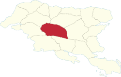
Arsad (abbreviated AS) is a region of Gylias. Located in central Gylias, it borders Kausania and Mişeyáke to the north, Envadra to the east, Ḑarna and Tomes to the south, and Elena to the west.
Geography
The region's territory is flat and dominated by the Laişyn plain. The biggest elevation occurs in the southwest, due to hills that mark the beginning of the Kackar mountains.
Major rivers include the Elşeti river and Rişys river, whose drainage basin covers most of the region, and the Ţikona river, which determines its boundaries with Kausania, Elena, and Tomes.
Demographics
The 2020 census recorded a population of 713.424. Large cities include Keraþ, Peisir, Releş, and Vilêna.
The main Gylic peoples in the area are Aréş, with a Rezakan minority near the borders with Kausania and Elena. There is a notable concentration of Hellene Gylians in the area neighbouring Nikopolis, and a strong Lusitan concentration in Vilêna. Vilêna was historically a Hellene settlement, which is reflected in its name, derived from Vila helêna ("Hellene Town").
Economy
The region's economy is based mainly around industry and agriculture.
Tourism mainly revolves around its natural attractions, with the Elşeti and Rişys being popular rivers for canoeing and kayaking.
Politics
The region's regional council is named the Arsad Regional Council, and its regional party is named the Arsad Party (French: Parti Arsad).
Arsad's political leanings have been to an extent unstable, with two main trends: support for the left-wing, and a strong ARENA base, Keraþ having been the site of the Impresa di Chieti during the Liberation War. ARENA is one of the main contenders for the mayoralty of Keraþ, and its candidate Nania Saeşe served as Governor from 1978 to 2002, becoming Gylias' longest-serving regional governor.