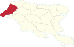
Tandar Region
Tandar | |
|---|---|
 | |
| Country | Gylias |
| Capital | Sænor |
| Area | |
| • Total | 96,738 km2 (37,351 sq mi) |
| Population (2020) | |
| • Total | 802,293 |
| • Density | 8.3/km2 (21/sq mi) |
| Demonym | Tandars |
Tandar (abbreviated TA) is a region of Gylias. Located in the north-west, it borders Salxar to the north, Kausania to the east, and Sváen to the south, across a gulf.
The region was historically a border region and the site of religious conflict, which is reflected in its flag.
Geography
Northern Tandar is mountainous and dominated by the Salxar mountains, while the south is flat and dominated by the Laişyn plain.
The Nerazur river determines its boundary with Kausania.
Demographics
The 2020 census recorded a population of 802.293. Large cities in the region include Antánas, Sænor, and Ďasla.
With regard to Gylic peoples, the region is unique in being populated mainly by Tanans.
Economy
The region's economy is mainly based on agriculture, mining, and industry.
The service sector is the biggest contributor to the regional economy; notable areas include tourism and the creative industries in Antánas and Sænor.
Politics
The region's regional council is named the Tandar Regional Council, and its regional party is named the Tandar Alliance (French: Alliance Tandar).
Tandar has historically been a "weathervane" politically, with a notable streak of support for Non-inscrits. This tendency is easily observable in presidential elections, where it is famous for never voting for the same party two elections in a row.