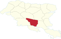
Ḑarna Region
Ḑarna | |
|---|---|
 | |
| Country | Gylias |
| Capital | Deðras |
| Area | |
| • Total | 87,464 km2 (33,770 sq mi) |
| Population (2020) | |
| • Total | 1,550,277 |
| • Density | 18/km2 (46/sq mi) |
| Demonym | Ḑarnan |
Ḑarna (abbreviated ḐR) is a region of Gylias. Located in the south, it borders Arsad and Envadra to the north, Aðuna to the east, Nauras to the south, and Tomes to the west.
Geography
The Kackar mountains cross the region from north to south, dividing its territory in two: the Laişyn plain in the east and the Niavelin plain in the west.
The Ţikona river determines its boundaries with Tomes, and the Nisár river determines part of its boundary with Aðuna.
Demographics
The 2020 census recorded a population of 1.550.277. Large cities include Deðras, Riáona, and Náunai.
The main Gylic peoples in the area are Aðunese, with an Aréş minority in the north.
Economy
The region's economy is based on industry, the service sector, and agriculture. The Ţiksagon includes the cities of Riáona and Náunai, contributing to a strong electronics industry.
Tourism is a major contributor to Ḑarna's economy, particularly for mountaineering and winter sports.
Politics
The region's regional council is named the Ḑarna Regional Council, and its regional party is named the League for Ḑarna (French: Ligue pour Ḑarna).
Politically, Ḑarna is closely competitive between socialism and conservatism. Former Governor Margaret Roberts (1982–1998), one of Gylias' longest-serving regional governors, is famous as a pioneer of green conservatism.