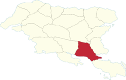
Aðuna Region
Aðuna | |
|---|---|
 | |
| Country | Gylias |
| Capital | Tavis |
| Area | |
| • Total | 92,421 km2 (35,684 sq mi) |
| Population (2020) | |
| • Total | 1,579,901 |
| • Density | 17/km2 (44/sq mi) |
| Demonym | Aðunan |
Aðuna (abbreviated AÐ) is a region of Gylias. Located in the south, it borders Envadra to the north, Herlan to the east, Nerveiík-Iárus-Daláyk to the south, and Ḑarna to the west.
Geography
The region's territory is largely flat and dominated by the Niavelin plain, with the more elevated Sykéir hills in the south.
The Nazar river determines its boundaries with Envadra, and the Nisár river determines part of its boundary with Ḑarna.
Demographics
The 2020 census recorded a population of 1.579.901. Large cities include Tavis, Þyrad, Aðnat, Tezira, Laiýs, and Rance.
The main Gylic peoples in the area are Aðunese, with minorities of Varans in the north around Þyrad and Ŋej in the south near Laiýs.
Economy
The region's economy is based on industry, the service sector, and agriculture. The Ţiksagon includes the cities of Aðnat, Tezira, and Laiýs, contributing to a strong electronics industry.
Tourism mainly focuses on the southern coast's beaches and surfing spots.
The Mava Organisation plays a large role in the economies of the "four cities", Aðnat, Tezira, Laiýs, and Rance.
Politics
The region's regional council is named the Aðuna Regional Council, and its regional party is named the Aðuna Democratic Alliance (French: Alliance démocratique d'Aðuna).
Aðuna's politics have been shaped by historical circumstance and the presence of the Mava Organisation in the south, producing a mixture of Progressive Alliance, National Bloc, and Non-inscrits support.
