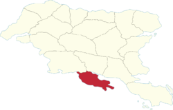
Nauras Region
Nauras | |
|---|---|
 | |
| Country | Gylias |
| Capital | Nyretak |
| Area | |
| • Total | 59,801 km2 (23,089 sq mi) |
| Population (2020) | |
| • Total | 1,370,070 |
| • Density | 23/km2 (59/sq mi) |
| Demonym | Nauran |
Nauras (abbreviated NA) is a region of Gylias. Located in the south, it borders Tomes and Ḑarna to the north.
Geography
The region's territory is crossed by the Kackar mountains through the middle, while the coastal areas are flat plains.
The Ţikona river determines its boundary with Ḑarna.
Demographics
The 2020 census recorded a population of 1.752.702. Large cities include Arnak, Narsiad, and Estro.
The main Gylic peoples in the area are Erlan, with a Tomesian minority in the north-east.
Economy
The region's economy is based on industry, the service sector, with agriculture having comparatively less importance. The Ţiksagon includes the cities of Arxas and Kalyta, contributing to a strong electronics industry.
Tourism is mainly based on mountaineering and winter sports, beach and surfing spots on the southern coast, and cultural tourism, especially in Ostara.
Politics
The region's regional council is named the Nauras Regional Council, and its regional party is named the Nauras Party (French: Parti Nauras).
Nauras has historically been evenly divided between the Progressive Alliance and National Bloc, with a notable non-inscrit left presence in the cities of Ostara and Arxas.
