Slirnia
Republic of Slirina Republika Slirnija (Slirnian) | |
|---|---|
Motto: "Istina Pobjeđuje" "Truth Prevails" | |
 | |
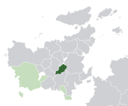
 Location of Slirnia | |
| Capital and largest city | |
| Official languages | Slirnian |
| Recognised regional languages | Minilovan, Miersan, Gaullican, Amathian and Lemovician |
| Religion | See Religion in Slirnia |
| Demonym(s) | Slirnian |
| Government | Unitary parliamentary constitutional republic |
| Marija Žalac Jovan Tasić Milenko Novaković | |
• Premier | Irena Mesić |
| Suzana Cvetković | |
| Legislature | Parliament |
| Establishment | |
• Duchy | c. 870 |
• Union | 1462 |
• Kingdom | 1780 |
| 1927 | |
| 12 February 1935 | |
| 3 November 1936 | |
• Current Constitution | 1 January 1980 |
| Area | |
• | 136,730 km2 (52,790 sq mi) |
| Population | |
• 2021 estimate | 5,723,452 |
• 2015 census | 5,511,345 |
• Density | 41.86/km2 (108.4/sq mi) |
| GDP (PPP) | 2021 estimate |
• Total | $104,533 million |
• Per capita | $18,264 |
| GDP (nominal) | 2021 estimate |
• Total | $72,988 million |
• Per capita | $12,752 |
| Gini (2020) | 23.1 low |
| HDI (2020) | very high |
| Currency | Slirnian Tolar [a] (STO) |
| Date format | yyyy/mm/dd |
| Driving side | right |
| Calling code | +578 |
| Internet TLD | .sl |
| |
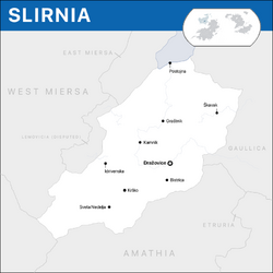
Slirnia (Slirnian: Slirnija), officially the Republic of Slirnia (Slirnian: Republika Slirnija), is a landlocked mountainous country located in the continent of Euclea. It is bordered clockwise, by East Miersa, Gaullica, Amathia, Minilov, Lemovicia and West Miersa; its only coast is reduced to a lakeshore on its north. The territory of Slirnia covers 136,730 kilometres square which distribute between snowed peaks and fertile plains, where the majority of its 5,723,452 inhabitants live.
Prior to the formation of the first Slirnian state, the territory was divided in numerous duchies and principalities, which lived during most of their time under the thrones of other foreign crowns. It was, however, Tomislav Golubović, who unified most of these reigning houses under the Duchy of Dražovice circa 870, marking the first historical trace for the identity of th nation. The Duchy prevailed during the decades cored in the castle of Dražovice until in 1462, the Domnitor Manuel III inherited the territories forming the Unio Trium Nationum, uniting the crowns of Amathia, Dražovice and Carinthia. The personal union between the three crowns, however, was only going to consolidate after a series of conflicts and battles, which concluded during the Great Rebellion of Tirideva that provided Miruvian and Slirnian nobles with a similar position in the structure of the Union as the Amathian ones. The Union would dissolve in 1780, separating the three crowns and establishing the Kingdom of Slirnia under the Belojević House, a state that survived different reigning houses and invasions until the Functionalist occupation of Slirnia during the start of the Great War in 1927. The occupation would remain during most of the course of the international conflict, counting with advances of the Amurgist Amathia on the south.
The end of the Great War saw the return of Slirnian power to the territory and the retirement of Entente forces. The creation of a Slirnian state was proclaimed with the Treaty of _ in 1936, which consolidated the Principality of Slirnia and the inaugural of Prince Tomislav I on the throne. However, a difficult economic panorama and a lack of national unity made the Principality fell in important conflicts. The appearance of councillist revolutionaries created the right moment for the overthrown of the throne and by December of 1935, the country was already immersed in a civil war that would later be known as the Revolution of 1936, year in which it coursed most of its events. Partisans sieged the capital Dražovice and in November 3, they entered in the Princely Palace of Slirnia, achieving the objective of overthrowing the crown an establishing a socialist republic, known between 1936 and 1980 as the Socialist Republic of Slirnia. The new socialist state followed the councils model of Kirenia and the Amathian Council Republic. The SRS remained during its first 24 years under the governments of the Slirnian Socialist Labour Party, until in 1960, the party was absorbed by the Slirnian Section of the Worker's Internationale, with which the nation shifted towards an authoritarian model of governance heavily marked by strict restrictions on the press, personal and collective freedoms and an alignment with the Amathian Equalist Republic. Having achieved a considerable economic development on the previous years, the nation gradually fell into isolation with the government of Slobodan Bijedić, the longest in the political history of the nation. During the decade of the '70s, civil unrest and state repression became more notorious and the incident of the Arsenije Karanović Nuclear Plant forced Ratko Vukašinović to resign. Followed by Pavle Vukomanović, the SRS started a period of important economic difficulties and social discomfort with the regime; the ineffiency of new measures and a students and later workers' movement made the government fell and in 1979, Vukašinović left the office in favour of Petrija Kuzmanović from the Socialist Democratic Party, who led the liberalisation of the nation.
Slirnia is a unitary parliamentary constitutional republic with a social market high-income economy that continues showing signs of the socialist era. The nation outstands in South Euclea for ranking high in women participation, civil liberties, press freedom, democratic governance, housing and overall quality of life. Slirnia is a member of the Euclean Common Defense Treaty Organization, the Community of Nations, the Global Institute for Fiscal Affairs, the International Trade Organization and is a founding member of the Association of South Euclean States. As of 2020, it is an officially recognised candidate for a membership of the Euclean Community.
History
Early settlements
Duchy of Dražovice (1400–1780)
Kingdom of Slirnia
Great War and occupation (1927-1935)
Principality of Slirnia (1935-1936)
Slirnian Revolution of 1936
Socialist Republic of Slirnia (1936-1980)
Republic of Slirnia (1980-present)
Geography
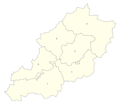
Slirnia covers a total extension of 136,730 km2 and it is entirely located in the central area of Euclea bordering six countries. Its territory lies completely between the Mendija Mountains on the west and south bordering Lemovicia and Minilov, it is also in this mountains chain where the Štiavnica Mountain of 2655 metres (8710.63 ft) mark the highest point in the territory; on its east and north borders with East and West Miersa, the territory is characterised by lower high lands and rolling hills; the centre of the coutry is mostly composed by woods and fertile plains generally used for farming or as protected areas. The different topographic areas in the whole territory of Slirnia have produced a variety of regions with their own characteristics, an issue that has impacted on the regional identities across the country. The eastern regions and the south of Vitanje are marked by the presence of high mountains and woods, while as one moves farther to the centre of the country, mountains transform to high lands until it faces the central plains that covers most of the Šavnik, Dražovice, Andrijevica and Radovljica regions with occasional lower hills covered by woods, specially around Dražovice in Šavnik and most of Andrijevica.
The presence of mountains have ensured to Slirnia a fertile soil and large reserves of water underground and in lakes. The country has three rivers that are often considered the most important, these are the Čik River known by crossing the city of Dražovice, the Željeznica River that originates in the Mendija Mountains and crosses the regions of Illirska and Vitanje towards Amathia and the Đetinja River that covers an extension from Gaullica to Radovljica and Andrijevica. Around these, life has been organised since ancient times as they have produced fertile lands throughout most of the territory of Slirnia, specially usable for agriculture and livestock farming, an economic sector which has been one of the most important in Sliria.
Geographic conditions have also had an important impact on the flora and fauna found in the different regions that compose the country; in general terms, plants and animals are those common to the rest of the central area of Euclea. Although Slirnia does not have a national animal, the red deer is often recognised as typical to the area and has today a significant art in the national identity and, although, Red deer is typical of the high lands and woods, it has expanded over the years and is considered a widespread species. Slirnia has several domestic breeds of diary cattle, which are important to the tertiary sector of the economy of the country; the most recognised of all is the Holstein, however, other introduced breeds have gained popularity such as the Gaullican Montbéliarde and the Estmerish Hereford. Deciduous trees constitute most of the trees flora on the country and different types can be found on mountainous regions or in the central plateau.
Horses in the plains of Andrijevica, near the River Čik.
With 2,655 mts, the Štiavnica Mountain is the highest peak of Slirnia and delimites the border with Lemovicia.
Winter landscape near Pljevlja, highlands here mark the limit with East Miersa.
Church of the town of Herceg in Illirska during Winter.
Cattle near Orrantia, Illirskan enclave in Vitanje.
Regional road in Vitanje overlooking the highlands.
Climate
Politics
Foreign relations
Administrative divisions
|
|


