Auralia: Difference between revisions
No edit summary |
No edit summary |
||
| Line 3: | Line 3: | ||
{{Infobox country | {{Infobox country | ||
|native_name = | |native_name = Áurallià | ||
|conventional_long_name = Auralian Commonwealth | |conventional_long_name = Auralian Commonwealth | ||
|common_name = Auralia | |common_name = Auralia | ||
| Line 29: | Line 29: | ||
|demonym = Auralian | |demonym = Auralian | ||
|government_type = {{wp|Parliamentary}}<br>{{wp|elective monarchy}} | |government_type = {{wp|Parliamentary}}<br>{{wp|elective monarchy}} | ||
|leader_title1 = [[ | |leader_title1 = [[King of Auralia|King]] | ||
|leader_name1 = | |leader_name1 = Matchino Chilarrie | ||
|leader_title3 = [[Speaker of the Chamber (Auralia)|Speaker of the Chamber]] | |leader_title3 = [[Speaker of the Chamber (Auralia)|Speaker of the Chamber]] | ||
|leader_name3 = | |leader_name3 = Canya Jerong | ||
|leader_title4 = [[Minister of State (Auralia)|Minister of State]] | |leader_title4 = [[Minister of State (Auralia)|Minister of State]] | ||
|leader_name4 = | |leader_name4 = Riana Maouigah | ||
|leader_title5 = [[Minister of Defense (Auralia)|Minister of Defense]] | |leader_title5 = [[Minister of Defense (Auralia)|Minister of Defense]] | ||
|leader_name5 = | |leader_name5 = Quadport Wyeallicbah | ||
|leader_title6 = [[Chief of Staff (Auralia)|Chief of Staff]] | |leader_title6 = [[Chief of Staff (Auralia)|Chief of Staff]] | ||
|leader_name6 = | |leader_name6 = Wanmoor Canya | ||
|sovereignty_type = History | |sovereignty_type = History | ||
|sovereignty_note = | |sovereignty_note = | ||
| Line 91: | Line 91: | ||
}} | }} | ||
'''Auralia''' ({{wp|Tetun language|Auralian}}: Áurallià), officially called the '''Auralian Commonwealth''', is a country in Central [[Flonesia]]. Auralia is situated on the main island of [[Flonesia]] named | '''Auralia''' ({{wp|Tetun language|Auralian}}: Áurallià), officially called the '''Auralian Commonwealth''', is a country in Central [[Flonesia]]. Auralia is situated on the main island of [[Flonesia]] named [[Aralona]] and thus borders only one nation to the southwest, XXX. [[Ironey]], Auralia's {{wp|capital}} city, and [[Hinser]] as the most populous cities are the two main cultural and economic centres of Auralia. Other major cities include [[Helmer (Auralia)]], [[Uraka]], [[Goalai]], [[Dawlun]], [[Damien]], [[Urande]] and [[Himmers]]. With an estimated population of 19,258,000 and a land area of 1,086,300 km<sup>2</sup> (419,400 sq mi), Auralia is both the second-most populous and second largest country in Flonesia. Auralia is a {{wp|Parliamentary}} {{wp|elective monarchy}} ever since its independence in 1964 from the XXX Empire. the current {{wp|monarch}} is Matchino Chilarrie, elected in 2016. | ||
The area of what is now Auralia was once settled by [[Flonesian people|Flonesian]] tribes before their genetics splited from their seafaring cousins around 1,000 BCE. Following 1750, modern day Auralia was colonized by the XXX empire allowing Auralians access to the partially globalized world, although limited. After the XXX War ended in XXX, Auralia declared independence from the already falling XXX empire in 1964 with little to no objections. | The area of what is now Auralia was once settled by [[Flonesian people|Flonesian]] tribes before their genetics splited from their seafaring cousins around 1,000 BCE. Following 1750, modern day Auralia was colonized by the XXX empire allowing Auralians access to the partially globalized world, although limited. After the XXX War ended in XXX, Auralia declared independence from the already falling XXX empire in 1964 with little to no objections. | ||
Today, Auralia is cultural powerhouse and is one of the best destination for tourism with over 75 million tourists in 2018. With a large {{wp|economy}} and a high {{wp|Human Development Index|HDI}}, Auralia is a well developed nation. Additionally, it ranks highly in {{wp|education}}, political and {{wp|personal freedom}}, {{wp|healthcare}}, and {{wp|life expectancy}}. Generally considered to be one of the world's great powers, it is a permanent member state of the [[Union of Realms]] since XXX and a recognized country possessing nuclear weapons. | Today, Auralia is cultural powerhouse and is one of the best destination for tourism with over 75 million tourists in 2018. With a large {{wp|economy}} and a high {{wp|Human Development Index|HDI}}, Auralia is a well developed nation. Additionally, it ranks highly in {{wp|education}}, political and {{wp|personal freedom}}, {{wp|healthcare}}, and {{wp|life expectancy}}. Generally considered to be one of the world's great powers, it is an ally of XXX, a permanent member state of the [[Union of Realms]] since XXX and a recognized country possessing nuclear weapons. | ||
== Etymology == | == Etymology == | ||
''TBA'' | ''TBA'' | ||
== History == | == History == | ||
=== Early History === | |||
''TBA'' | |||
=== XXX Empire === | |||
''TBA'' | |||
=== XXX War === | |||
''TBA'' | |||
=== Modern Day === | |||
''TBA'' | ''TBA'' | ||
== Geography == | == Geography == | ||
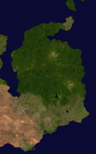
[[File:Auralia satellite.png|thumb|left|Map of Auralia from space.]] | |||
Auralia is situated in the northern region of the island of [[Aralona]] being bordered by only the nation of XXX to the south. The nation is bordered by the [[White Sea (Gentu)|White Sea]] to the north and west, the [[Biscay Sea]] to the south, and the [[South Nullaric Ocean]] to the east. The seas and oceans around Auralia are filled with {{wp|coral reef}}. The biggest reef being the [[Great Orion Reef]], the worlds second largest reef, which lies 500 km from the southern coast and extends for over 2,000 km (1,200 mi) on all directions. | |||
Auralia's most prominent geographical feature is its [[Auralian Rainforest|large rainforest]] that covers over 73.5% of the nation's land area. Auralia's geography is relatively flat, its highest point being [[Mount Highno|Mt. Highno]], 754 meters above {{wp|sea level}} at the central region of the country. The southern region of the country is dominated by plains which is the most densely populated of all of Auralia's regions (59.7/km<sup>2</sup>). To the southwest is the [[XXX]] desert to the southwest of Auralia which acts as a natural border between the nation and XXX. | |||
The territorial extent of Auralia is 1,086,300 km<sup>2</sup> or 419,400 sq mi; this makes Auralia the 2nd largest nation in [[Flonesia]] and the XXXth in the world. Despite Auralia's size, their are only 2 major rivers that flow through the nation: [[Cylon]] and [[Hinsen]]; they are 963 km and 1598 km long respectively. Additionally, Due to its geological activity and diverse landscape, Auralia is a deposit for numerous natural resources and biodiverse habitats. | |||
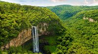
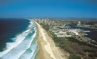
{{Gallery | |||
|title=Images of the geography of Auralia | |||
|width=200 |height=120 | |||
|align=center | |||
|footer= | |||
|File:Amazon 870-870x480.jpg | |||
|alt1= | |||
|Waterfall at the Auralian Rainforest | |||
|File:CaviaArticleGeo3.jpg | |||
|alt2= | |||
|The southern plains in Vioray | |||
|Australiabeaches.jpg | |||
|alt3= | |||
|Aerial view of the southern coast of Auralia | |||
}} | |||
=== Climate === | |||
''TBA'' | |||
=== Biodiversity === | |||
''TBA'' | ''TBA'' | ||
== Politics == | == Politics == | ||
''TBA'' | ''TBA'' | ||
Revision as of 13:53, 15 February 2022
This article is incomplete because it is pending further input from participants, or it is a work-in-progress by one author. Please comment on this article's talk page to share your input, comments and questions. Note: To contribute to this article, you may need to seek help from the author(s) of this page. |
Auralian Commonwealth Áurallià | |
|---|---|
| Motto: God save the Commonwealth | |
| Anthem: XXX | |
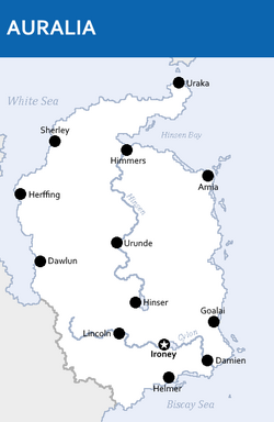 Map of Auralia | |
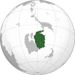 Location of Auralia (Green) in Flonesia (Dark Grey) | |
| Capital | Ironey |
| Largest city | Hinser |
| Official languages | Auralian |
| Recognised national languages | XXX |
| Ethnic groups (2020) | 78% Auralian 12.6% XXX 9.4% Others |
| Demonym(s) | Auralian |
| Government | Parliamentary elective monarchy |
• King | Matchino Chilarrie |
| Canya Jerong | |
| Riana Maouigah | |
| Quadport Wyeallicbah | |
| Wanmoor Canya | |
| History | |
• Auralian Tribes | circa 1,000 B.C.E. |
• XXX | 1750 |
• XXX War | XXX |
• Independence | 21 June 1964 |
| Area | |
• Total | 1,086,300 km2 (419,400 sq mi) (XXX) |
• Water (%) | 7.6 |
| Population | |
• 2021 estimate | |
• 2019 census | |
• Density | 17.7/km2 (45.8/sq mi) |
| GDP (PPP) | 2019 estimate |
• Total | |
• Per capita | |
| GDP (nominal) | 2020 estimate |
• Total | |
• Per capita | |
| Gini (2017) | low (XXX) |
| HDI (2016) | very high (XXX) |
| Currency | Auralian Arok (AUA, ᐂ) |
| Date format | dd-mm-yyyy |
Auralia (Auralian: Áurallià), officially called the Auralian Commonwealth, is a country in Central Flonesia. Auralia is situated on the main island of Flonesia named Aralona and thus borders only one nation to the southwest, XXX. Ironey, Auralia's capital city, and Hinser as the most populous cities are the two main cultural and economic centres of Auralia. Other major cities include Helmer (Auralia), Uraka, Goalai, Dawlun, Damien, Urande and Himmers. With an estimated population of 19,258,000 and a land area of 1,086,300 km2 (419,400 sq mi), Auralia is both the second-most populous and second largest country in Flonesia. Auralia is a Parliamentary elective monarchy ever since its independence in 1964 from the XXX Empire. the current monarch is Matchino Chilarrie, elected in 2016.
The area of what is now Auralia was once settled by Flonesian tribes before their genetics splited from their seafaring cousins around 1,000 BCE. Following 1750, modern day Auralia was colonized by the XXX empire allowing Auralians access to the partially globalized world, although limited. After the XXX War ended in XXX, Auralia declared independence from the already falling XXX empire in 1964 with little to no objections.
Today, Auralia is cultural powerhouse and is one of the best destination for tourism with over 75 million tourists in 2018. With a large economy and a high HDI, Auralia is a well developed nation. Additionally, it ranks highly in education, political and personal freedom, healthcare, and life expectancy. Generally considered to be one of the world's great powers, it is an ally of XXX, a permanent member state of the Union of Realms since XXX and a recognized country possessing nuclear weapons.
Etymology
TBA
History
Early History
TBA
XXX Empire
TBA
XXX War
TBA
Modern Day
TBA
Geography
Auralia is situated in the northern region of the island of Aralona being bordered by only the nation of XXX to the south. The nation is bordered by the White Sea to the north and west, the Biscay Sea to the south, and the South Nullaric Ocean to the east. The seas and oceans around Auralia are filled with coral reef. The biggest reef being the Great Orion Reef, the worlds second largest reef, which lies 500 km from the southern coast and extends for over 2,000 km (1,200 mi) on all directions.
Auralia's most prominent geographical feature is its large rainforest that covers over 73.5% of the nation's land area. Auralia's geography is relatively flat, its highest point being Mt. Highno, 754 meters above sea level at the central region of the country. The southern region of the country is dominated by plains which is the most densely populated of all of Auralia's regions (59.7/km2). To the southwest is the XXX desert to the southwest of Auralia which acts as a natural border between the nation and XXX.
The territorial extent of Auralia is 1,086,300 km2 or 419,400 sq mi; this makes Auralia the 2nd largest nation in Flonesia and the XXXth in the world. Despite Auralia's size, their are only 2 major rivers that flow through the nation: Cylon and Hinsen; they are 963 km and 1598 km long respectively. Additionally, Due to its geological activity and diverse landscape, Auralia is a deposit for numerous natural resources and biodiverse habitats.
Climate
TBA
Biodiversity
TBA
Politics
TBA
Economy
TBA
Demographics
TBA
Culture
TBA


