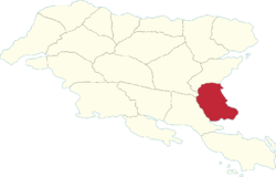
Herlan Region
Herlan | |
|---|---|
 | |
| Country | Gylias |
| Capital | Arnak |
| Area | |
| • Total | 70,941 km2 (27,390 sq mi) |
| Population (2020) | |
| • Total | 1,752,702 |
| • Density | 25/km2 (64/sq mi) |
| Demonym | Herlanian |
Herlan (abbreviated HE) is a region of Gylias. Located in the south, it borders Envadra and Nezyál to the north, and Aðuna to the west.
Geography
The region's territory is largely flat and dominated by the Niavelin plain, with some elevation provided by the Sykéir hills in the south and the Sarðe hills in the north.
The Nazar river determines its boundary with Envadra.
Demographics
The 2020 census recorded a population of 1.752.702. Large cities include Arnak, Narsiad, and Estro.
The main Gylic peoples in the area are Varan, with an Aðunese minority in the east.
Economy
The region's economy is based on industry, the service sector, and agriculture.
Narsiad is home to Anca Déuréy University, while Estro is home to a Cacertian Royal Navy base.
Politics
The region's regional council is named the Herlan Regional Council, and its regional party is named the Herlan Rally (French: Rassemblement Herlan).
Herlan has historically been a markedly left-wing region, with the non-inscrit left enjoying a stronghold in the city of Narsiad.