Emessa
This article is incomplete because it is pending further input from participants, or it is a work-in-progress by one author. Please comment on this article's talk page to share your input, comments and questions. Note: To contribute to this article, you may need to seek help from the author(s) of this page. |
Republic of Emessa Repubblika ta' Imisra | |
|---|---|
| Motto: Viribus Unitis "With United Forces" | |
 | |
| Capital and largest city | Himera |
| Official languages | Emessan |
| Recognised national languages | Atudite |
| Recognised regional languages | |
| Demonym(s) | Emessan |
| Government | Unitary presidential republic |
• President | Placeholder McPresident |
• Vice-President | Placeholder |
| Senate | |
| Establishment | |
• Colonisation by Etruria | 1843 |
• Independence Wars | 1943-1946 |
• Emessan Independence | 1949 |
| Area | |
• | 22,487 km2 (8,682 sq mi) |
• Water (%) | 3.1 |
| Population | |
• Estimate | 5,681,900 |
• 2015 census | |
• Density | 247.8/km2 (641.8/sq mi) |
| GDP (PPP) | 2020 estimate |
• Total | |
• Per capita | |
| GDP (nominal) | 2020 estimate |
• Total | |
• Per capita | |
| Gini (2020) | medium |
| HDI (2020) | very high |
| Currency | Emessan Lira |
| Date format | dd.mm.yyyy |
| Driving side | right |
| Internet TLD | .em |
Emessa (/ˈɛməsə/ E-mə-sə, officially the Rebublic of Emessa (Emessan: Repubblika ta' Imisra [rɛˈpʊbːlɪkɐ tɐ ˈɑmɑsˤɾ]) is a transcontinental country in the Solarian Sea, halfway between Southeast Euclea and Northwest Coius. It lies 94 km (58 mi) southeast of Paretia, 100 km (62 mi) west of Tsabara and 179 km (111 mi) east of Etruria. Emessa's location at the crossroads of the Euclean and Coian continents has shaped its rich history and shaped a national identity of religious and ethnic diversity. The official language is Emessan, a language related to Rahelian and Atudite, yet distinct due to its heavily solaricized traits.
Emessa has been continuously inhabited since the Paleolithic age. Owing to their strategic location in the middle of the Solarian Sea, the islands have been contested and ruled by a succession of powers, from the Nimene Civilisation in the Late Bronze Age to foreign empires, such as the Atudites, Piraeans, Solarians, Arsanids, Crusaders, and, more recently, Etruria and Gaullica. As a result, Emessa is home to a diverse mix of cultures and influences, with many archaeological and historical sites of differing traditions. Historically, the region has been controlled by a mix of Tribunals and merchant city-states, with the regional power structure in the Middle Ages being largely derived from late Solarian administration, instead of feudal power dynamics more common in Euclea.
|Etrurian presence in the archipelago began in 1378, with the conquest of the port city of Nineve by the thalassocratic Republic of Accadia. This lead to increased influence of Etrurian maritime republics in the Bay of Povelia, with various other ports becoming afilliated to such republics, notably the Republic of Accadia, the Republic of Amelia and Povelia. With the War of the Amelian League in 1450, Povelia gained significant concessions in the island, with near-absolute hegemony in Emessa's trading ports. To secure this position, Povelia turned Himera into a large fortified trading hub directly under its control, while influencing the various Emessan Tribunals. This influence was disputed with various Rahelian sheikhdoms and, later, Crusading States predominantly of Gaullican sponsorship. Etrurian rule of Emessa formally began in 1814, with the conquest of Himera and the eventual complete control of the island in 1843. The islands saw fighting during the Battle of Emessa in the Great War and again in the Solarian War, also called War of Independence in the country. Emessa became a joint trust territory, and achieved independence in 1949.
Today, Emessa is a parliamentary democracy with confessionalist characteristics, with most parties representing either of the islands' religious communities: Sotirianity, Irfan, and Atudism. Despite periods of troubles, the country has remained fairly calm and prosperous, with a upper middle income economy driven by the tertiary sector, notably tourism and banking, and a high human development index. Emessa is a member of the Community of Nations, the Aurean Forum, the International Council for Democracy, the International Trade Organisation, and the Global Institute for Fiscal Affairs. Historically maintaining a policy of armed neutrality, the country has nonetheless moved closer to the Euclean Community since the Alban War, with accession negotiations being underway since 2012.
History
Pre-Historic and Ancient Emessa
Main Articles: Nimene Civilization

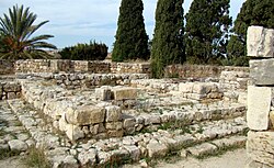
Hunter-gatherer societies settled the island as early as 9000 BC, with ancient water wells being discovered in the vicinity of Beni Taghit, and multiple fossilized footprints towards the islands interior. The earliest Village Community was discovered as early as 7900 BC. By 2000 BC, Emessa was the birthplace of one of Euclea's oldest advanced civilizations, the Nimenes. Nimene civilization was mainly centered around walled settlements, the most preserved of which is the Azkart Site, where multiple ceramics and a yet to be deciphered written script were found.
Major tin deposits, as well as exotic textiles and dyes had turned Emessa into a major commerce hub, turning several Nimene city states such as Tanit and Nineve into large ports around 1100 BC. In the same period, a new written alphabet was popularized among Nimenes in Emessa and beyond to facilitate trade. Independently, these city states later established various trading enclaves abroad, with various Nimene temple ruins and settlements being found in Etruria, Tsabara, Paretia and Piraea. Circa 800 BC, the Nimenes began a period of decline, with several of these overseas settlements being conquered by Piraeans and settlements in Emessa itself being overran by Piraeans. This brought significant cultural exchange to the island, with Piraean and Nimene city states coexisting for multiple centuries.
Solarian Period
With the usage of new metals such as iron, Emessa's position as a key supplier of tin in the area was no longer of great relevance. While impoverished, the various Emessan city states remained strategically located in various trade routes, making them valuable targets for the rising Solarian Republic. A coalition of Emessan City States, led by Adat Elishat and Attalus of Myrtos, succesfully repelled a Solarian invasion following the Battle of Cape Castor in 308 BC. This coalition was later defeated in 303 BC by General Flavius the Younger after a a three year long campaign.
During the centuries of Solarian rule, Emessa was heavily sotirianized, with much of its cultural composition being altered. Piraeans were priviledged along with the newly arrived Sotirians, while the Nimenes were cast aside politically. Emessa prospered as a major trading hub under Solaria, being central for the commerce networks linking Euclea and Coius. The keystone to this network was the rapidly growing port city of Himera, the largest city in the island. With the expansion of the Arasanid Dynasty in Coius, Emessa's position shifted from a trade node to a bastion. In 60 BC, Emessa was organized under the Cretician Reforms as a Praefectus Praetorio, under direct military administration. The island was heavily fortified and was the battleground of multiple wars between Solaria and the Arasanids. This period of dispute saw the island being intermittently controlled by Irfanic rulers, though the Solarians eventually reestablished their control. During these wars, Solarian Emperor TBD authorized the migration of various Atudite communities into Southern Emessa, in order to help bolster various defensive positions against the Arsanids, with the Atudite Soldiers being renowned for their victory and resilience in the 8 year long Siege of Devara.
Middle Ages
Main Articles: Emessan Tribunals
With the fall of the Solarian Empire in 426 AD, Emessa quickly fell under control of Irfanic Kingdoms to the south, following a series of wars of conquest. This led to the creation of the short lived Saramid Sheikhdom, which ruled Emessa in its entirety from 435 AD to 458 AD, with succession issues causing the splinter of the Sheikhdom into various smaller states, who managed to solidify their power primarily in southeastern Emessa. While these Irfanic rulers sought to convert those willing, they still ruled over a majority Sotirian population, with these petty sheikhdoms being notably tolerant, employing numerous Atudites and Sotirians in state duties. Despite this, Irfanic rule struggled primarily in the heavily populated, militarized and sotirian west. Emessa was fully reconquered by sotirians in 514, with the Verliquoian Empire establishing control that would endure until 914 AD.
With the Collapse of the Verliquoians, Emessa was under control by a collection of Petty Kingdoms. These kingdoms, also known as Tribunals, inheriting tradition primarily from the Solarian Empire, differed significantly in organization compared to its continental Euclean feudal counterparts. Such tribunals were distinguished by a lack of land inheritance on behalf of the ruler, with it instead being appointed by a council of elders. The Tribune acted as a central ruler and arbiter of laws, under the approval of the council. Emessa was divided under 4 Tribunals, of which the most notable was Pretoriana (Emessan: Tribuna Pretorjana), centered around Himera. These Tribunals were backed militarily by various mercenaries and citizen militias, with several mercenaries having achieved significant political prevalence, as councillors or Tribunes.
Early Modern Period
- Irfanic Conquest
- Colonization
Modern Period
- Solarian Wars and Independence
Geography
Main Articles: Geography of Emessa
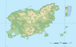
Emessa is divided into two main geographic regions: The island of Emessa itself, and the Alban Islands. Emessa is the largest island in the Solarian Sea, measuring 21826 square kilometers. The island is approximately 230km long from end to end and 120km at its widest. Emessa is located 100km from Paretia at its closest point, 124km away from Tsabara, and 179km away from Etruria. The physical relief of Emessa is defined by the Sannat Mountains, a mountain range whose highest point is Mount Qalb at 2980m. Emessa's geology is comprised primarily of limestone formations.
Climate
Emessa features a primarily mediterranean climate, with mild humid winters and dry warm summers. Snowfall occurs in the Sannat mountains during winter.
Emessa is among the warmest countries of Euclea, with average temperatures of 26 °C during the day and 15 °C during the night. Sunshine hours average at 3440 hours of sunshine a year, being among the countries with the most sunshine in Euclea.


