Auralia: Difference between revisions
No edit summary |
|||
| Line 186: | Line 186: | ||
! Map !! State !! Capital city !! Largest city !! Population<br><small>(December 2021)</small> | ! Map !! State !! Capital city !! Largest city !! Population<br><small>(December 2021)</small> | ||
|- | |- | ||
| rowspan="24" |<center>[[File:Auralia Province Map.png| | | rowspan="24" |<center>[[File:Auralia Province Map.png|300px]] | ||
</center> | </center> | ||
! colspan="5" |Subdivision | ! colspan="5" |Subdivision | ||
Revision as of 08:41, 16 February 2022
This article is incomplete because it is pending further input from participants, or it is a work-in-progress by one author. Please comment on this article's talk page to share your input, comments and questions. Note: To contribute to this article, you may need to seek help from the author(s) of this page. |
Auralian Commonwealth Áurallià | |
|---|---|
 Flag
 Coat of arms
| |
Motto: God save the Commonwealth | |
Anthem: XXX | |
 Map of Auralia | |
 Location of Auralia (Green) in Flonesia (Dark Grey) | |
| Capital | Ironey |
| Largest city | Hinser |
| Official languages | Auralian |
| Recognised national languages | XXX |
| Ethnic groups (2020) | 78% Auralian 12.6% XXX 9.4% Others |
| Demonym(s) | Auralian |
| Government | Parliamentary elective monarchy |
• King | Matchino Chilarrie |
| Canya Jerong | |
| Riana Maouigah | |
| Quadport Wyeallicbah | |
| Wanmoor Canya | |
| Legislature | Parliament |
| Haycato | |
| Representers | |
| History | |
• Auralian Tribes | circa 1,000 B.C.E. |
• XXX | 1750 |
• XXX War | XXX |
• Independence | 21 June 1964 |
| Area | |
• Total | 1,086,300 km2 (419,400 sq mi) (XXX) |
• Water (%) | 7.6 |
| Population | |
• 2021 estimate | |
• 2019 census | |
• Density | 17.7/km2 (45.8/sq mi) |
| GDP (PPP) | 2019 estimate |
• Total | |
• Per capita | |
| GDP (nominal) | 2020 estimate |
• Total | |
• Per capita | |
| Gini (2017) | low · XXX |
| HDI (2016) | very high · XXX |
| Currency | Auralian Arok (AUA, ᐂ) |
| Date format | dd-mm-yyyy |
Auralia (Auralian: Áurallià), officially called the Auralian Commonwealth, is a country in Central Flonesia. Auralia is situated on the main island of Flonesia named Aralona and thus borders only one nation to the southwest, XXX. Ironey, Auralia's capital city, and Hinser as the most populous cities are the two main cultural and economic centres of Auralia. Other major cities include Helmer (Auralia), Uraka, Goalai, Dawlun, Damien, Urande and Himmers. With an estimated population of 19,258,000 and a land area of 1,086,300 km2 (419,400 sq mi), Auralia is both the second-most populous and second largest country in Flonesia. Auralia is a Parliamentary elective monarchy ever since its independence in 1964 from the XXX Empire. The current monarch is Matchino Chilarrie, elected in 2016.
The area of what is now Auralia was once settled by Flonesian tribes before their genetics splited from their seafaring cousins around 1,000 BCE. Following 1750, modern day Auralia was colonized by the XXX empire allowing Auralians access to the partially globalized world, although limited. After the XXX War ended in XXX, Auralia declared independence from the already falling XXX empire in 1964 with little to no objections.
Today, Auralia is cultural powerhouse and is one of the best destination for tourism with over 75 million tourists in 2018. With a large economy and a high HDI, Auralia is a well developed nation. Additionally, it ranks highly in education, political and personal freedom, healthcare, and life expectancy. Generally considered to be one of the world's great powers, it is an ally of XXX, a permanent member state of the Union of Realms since XXX and a recognized country possessing nuclear weapons.
Etymology
The word Auralia derives from the XXX word of the same pronounciation for golden. When XXX first began visiting and mapping Flonesia in the XXXth century, the name Terra Auralia was naturally applied to the new territories of modern day Auralia and XXX due to the large abundance of gold found in the mountain and hills of Aralona. The name Auralia was popularised by the explorer XXX, who said it was "more agreeable to the ear, and an assimilation to the names of the other great portions of Gentu".
History
Early History
TBA
XXX Empire
TBA
XXX War
TBA
Modern Day
TBA
Geography

Auralia is situated in the northern region of the island of Aralona being bordered by only the nation of XXX to the south. The nation is bordered by the White Sea to the north and west, the Biscay Sea to the south, and the South Nullaric Ocean to the east. The seas and oceans around Auralia are filled with coral reef. The biggest reef being the Great Orion Reef, the worlds second largest reef, which lies 500 km from the southern coast and extends for over 2,000 km (1,200 mi) on all directions.
Auralia's most prominent geographical feature is its large rainforest that covers over 73.5% of the nation's land area. Auralia's geography is relatively flat, its highest point being Mt. Highno, 754 meters above sea level at the central region of the country. The southern region of the country is dominated by plains which is the most densely populated of all of Auralia's regions (59.7/km2). To the southwest is the XXX desert which acts as a natural border between the nation and XXX.
The territorial extent of Auralia is 1,086,300 km2 or 419,400 sq mi; this makes Auralia the 2nd largest nation in Flonesia and the XXXth in the world. Despite Auralia's size, their are only 2 major rivers that flow through the nation: Cylon and Hinsen; they are 963 km and 1598 km long respectively. Additionally, Due to its geological activity and diverse landscape, Auralia is a deposit for numerous natural resources and biodiverse habitats.
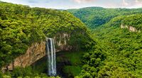
Waterfall at the Auralian Rainforest
- CaviaArticleGeo3.jpg
The southern plains in Vioray
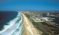
Aerial view of the southern coast of Auralia


Climate

The climate of Auralia is significantly influenced by ocean currents, including the XXX and XXX. Much of the northern and central part of the country has a tropical, predominantly summer-rainfall. The southern part of the country has a XXX climate. The southwest is arid to semi-arid.
Driven by climate change, average temperatures have risen more than 2°C since 1960. Associated changes in rainfall patterns and climate extremes exacerbate existing issues such as droughts and forestfires. 2015 was Auralia's warmest recorded year, and the 2016–2017 forestfire was the country's worst on record.
Biodiversity
Being a nation with a vast rainforests, Auralia is one of 17 megadiverse countries. Fungi typify that diversity—an estimated 250,000 species—of which only 5% have been described—occur in Auralia. Because of the continent's great age, extremely variable weather patterns, and long-term geographic isolation, much of Auralia's biota is unique. About 85% of flowering plants, 84% of mammals, more than 45% of birds, and 89% of in-shore, temperate-zone fish are endemic. Auralia has at least 755 species of reptile, more than any other country in Gentu. Despite Flonesia's megadiversity as a whole, it is the only continent that developed without feline species. Feral cats may have been introduced in the 17th century by XXX shipwrecks, and later in the 18th century by XXX settlers. They are now considered a major factor in the decline and extinction of many vulnerable and endangered native species.
Auralian rainforests are mostly made up of evergreen species, particularly eucalyptus trees in the less arid regions. Among well-known Flonesian animals are the monotremes; a host of marsupials, including the kangaroo which is the national animal of Auralia, wombat, and birds such as the emu and the kookaburra. Auralia is home to many dangerous animals including some of the most venomous snakes in the world. The bingo was introduced by XXX people who traded with Indigenous Auralians around 1000 BCE. Many animal and plant species became extinct soon after first human settlement; others have disappeared since XXX settlement, among them the hydran.
As of 2020, 73.5% of Auralia's area was covered in rainforests and at least 24%, was devoted to agriculture, two-thirds used for pastures and greenlands and the remainder for actual agricultural activities. The protection and preservation of nature is defined by the Constitution as a public duty and designated policy target; ecological protection is served and guaranteed through 34 national parks, 12 biosphere reserves, 235 nature parks and thousands of nature protection areas, landscape protection areas and natural memorials.
Politics


Auralia is a Parliamentary elective monarchy. The country has maintained a stable liberal democratic political system under its constitution. The Auralian system of government combines elements derived from the political systems of the XXX (a fused executive, constitutional monarchy and strong party discipline) and the XXX (federalism, a written constitution and strong bicameralism with an elected upper house), along with distinctive indigenous features.
The federal government is separated into three branches:
- Legislature: the bicameral Parliament, comprising the elected monarch, the Haycato, and the Representers;
- Executive: the Federal Executive Council of Auralia, which in practice gives legal effect to the decisions of the cabinet, comprising the prime minister and other ministers of state appointed by the governor-general on the advice of Parliament;
- Judiciary: the High Court of Auralia and other federal courts, whose judges are appointed by the elected monarch on advice of Parliament.
The current monarch is Matchino Chilarrie, elected in 2016, and the Speaker of the Chamber is Canya Jerong. In the Haycato (the upper house), there are 78 members: six from each individual state. The Representers (the lower house) has 151 members elected from single-member electoral divisions, commonly known as "electorates" or "seats", allocated to states on the basis of population. Elections for both chambers are normally held every three years simultaneously; Haycato members have overlapping six-year terms. Elections for monarchs are held when the current monarch resigns or dies and they can hold power for the rest of their lives if they so wish.
Administrative divisions
Auralia's federal system is represented and exercised through its 13 states. The states are then subdivided into districts as the smallest unit of administrations.
Districts are subject to the individual laws of the states, and therefore considerably variable, however in compliance with the supreme Constitution. Representers councils of the districts are directly voted by the public, and enact local laws and decisions based on the larger state's actions and legal situation; while each subject or level maintains bodies of delegates, solely the legislature of the state and its government is politically relevant to the entire country, seated in the state's capital.
| Map | State | Capital city | Largest city | Population (December 2021) | |
|---|---|---|---|---|---|

|
Subdivision | ||||
| Herffing | Herffing | 3,421,400 | |||
| Urande | Urande | 2,467,850 | |||
| Dawlun | Liga | 2,769,100 | |||
| — | — | 3,279,900 | |||
| Denel | Himmers | 1,270,500 | |||
| Uraka | Uraka | 767,200 | |||
| Sherley | Sherley | 496,010 | |||
| Goalai | — | 974,300 | |||
| Lincoln | Lincoln | 285,800 | |||
| Wandie | Damien | 2,453,290 | |||
| Amia | Amia | 200,100 | |||
| Hinser | Hinser | 720,190 | |||
| Helmer | Gigaroo | 152,360 | |||
| Ironey | Hinser | 19,258,000 | |||
Foreign relations
TBA
Military
TBA
Economy
TBA
Demographics
TBA
Culture
TBA
Gentu | |||||||||||||||||||||
|---|---|---|---|---|---|---|---|---|---|---|---|---|---|---|---|---|---|---|---|---|---|
| Fauna and Flora |
|  | |||||||||||||||||||
| History |
| ||||||||||||||||||||
| Culture | |||||||||||||||||||||
| Society and Demographics | |||||||||||||||||||||
| Geography |
| ||||||||||||||||||||
| Politics |
| ||||||||||||||||||||
| Sporting Unions |
| ||||||||||||||||||||
| Scales | |||||||||||||||||||||