Geography of Senria
This article is incomplete because it is pending further input from participants, or it is a work-in-progress by one author. Please comment on this article's talk page to share your input, comments and questions. Note: To contribute to this article, you may need to seek help from the author(s) of this page. |

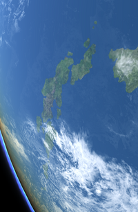
Senria comprises 12,814 islands and islets located to the south and west of Coius, of which about 520 are inhabited. The main portion of the country, the Senrian archipelago, is a stratovolcanic archipelago bordered by the Lumine Ocean to the west and north, the Bay of Bashurat to the northeast, the Rangyoku Strait to the east, and the Honghai Sea to the south and southeast. The four "main islands" of the Senrian archipelago, from east to west, are Tousuu, Kousuu, Yuusuu, and Gyousuu. Smaller islands within the Senrian archipelago include Kisima and Rousima, located north of Yuusuu and west of Kousuu; Kanasima, south of Kousuu; Sugisima, north of Kousuu; and Kaedezima, located between Yuusuu and Gyousuu. Within the larger Senrian archipelago, two subarchipelagos are typically identified - the Isotama Islands, to the northeast of the main islands, and the Hibotu Islands, the westernmost portion of the country. The archipelago also contains several thousand smaller islands and islets.
The Senrian archipelago stretches roughly 2,554 kilometers (1,587 miles) in length, but is comparatively narrow, only about 460 kilometers (285 miles) wide at its widest point, and no point in the archipelago is more than 158 kilometers (98 miles) away from the ocean. Most of the archipelago's terrain is highly mountainous, and, because of this, more than 65% of it is uninhabitable. As a result, the habitable areas - located primarily in coastal regions - are very heavily populated, giving Senria one of the highest population densities in the world, and most land which is suitable for development is in use. Land reclamation has been used to expand the amount of land available for human use, particularly in the years since the end of the Great War; roughly 0.6% of the country's total area is reclaimed land as of 2018. Senria's mountainous terrain also means it has few navigable rivers, though extensive coastal shipping, particularly within the Bay of Hisui, the Nangyoku and Ransou inland seas, and the Kahoumon and Toyozimon straits, compensates for this.

Because of its location along the boundary of the Lumine and Austral tectonic plates, the Senrian archipelago is significantly prone to earthquakes, volcanic activity, and tsunamis. The country has 117 active volcanoes, including three VEI-7 volcanoes and two Decade Volcanoes. Major seismic events, meanwhile, occur within Senria several times each century; the 1923 Great Kinkeidou earthquake killed between 100,000 and 150,000 people, while the 1982 Taiseiyou earthquake caused a tsunami with a maximum run-up height of roughly 10 meters (32 feet), though it caused only 104 fatalities.
Senria also controls the Sunahama Islands, a chain of twenty-eight atolls and islets located on the border of the Honghai and Coral seas. Of these, nineteen atolls are inhabited, while the other nine are uninhabited, either because of environmental factors such as a lack of fresh water or due to contamination from Senrian weapons testing. Obtained from Gaullica following the end of the Great War, the Sunahamas are also claimed by Shangea.
Senria has a total area of 609,136.64 km2 (235,189 sq mi); metropolitan Senria has an area of 589,191.68 km2 (227,488 sq mi) while the Sunahamas have an area of 19,944.96 km2 (7,701 sq mi). The Senrian archipelago lies roughly between latitudes 18° and 33°S and longitudes 146°W and 180°E; the Sunahamas are located roughly between latitudes 44° and 48°S and longitudes 105° to 115°W. The country's highest point is the peak of Mount Senzou, which stands 3,776 meters (12,388 feet) tall; its lowest natural point is Lake Notorigata, a now-partially-reclaimed lagoon located 4 meters (13 feet) below sea level. As an island nation, Senria has no land borders; however, it does share a sea border with Shangea in the Rangyoku Strait.
Islets on the northern coast of the Nangyoku Inland Sea.
Snow-capped mountains in the Senrian Aventines.
Forest and farmland in central Gyousuu.
The Agano River flowing through Nisiyama.
Lake Kimun, a crater lake in Yuusuu.


