Hoy Kok: Difference between revisions
Philimania (talk | contribs) No edit summary |
Philimania (talk | contribs) No edit summary |
||
| Line 38: | Line 38: | ||
| established_date3 = 1 Enero 1980 | | established_date3 = 1 Enero 1980 | ||
| established_event4 = [[Constitution of Hoy Kok|Constitution]] | | established_event4 = [[Constitution of Hoy Kok|Constitution]] | ||
| established_date4 = 8 Enero | | established_date4 = 8 Enero 1990 | ||
| area_km2 = 4,338 | | area_km2 = 4,338 | ||
| area_rank = XXX | | area_rank = XXX | ||
| Line 80: | Line 80: | ||
'''Hoy Kok''' ([[Palon language|Palon]]: Marcanta, [[Qiuese language|Qiuese]]: 海角, {{wp|Jyutping}}: Hoi2 Gok3), officially the '''State of Hoy Kok''', is a country in [[Hesterath]] located in the northern [[Red River Delta]] by the [[Horapon Sea]]. With a population of about 49,126,800 and an area of 11,325 km<sup>2</sup> (29,330.1 sq mi), it is the XXX populated region in Gentu. | '''Hoy Kok''' ([[Palon language|Palon]]: Marcanta, [[Qiuese language|Qiuese]]: 海角, {{wp|Jyutping}}: Hoi2 Gok3), officially the '''State of Hoy Kok''', is a country in [[Hesterath]] located in the northern [[Red River Delta]] by the [[Horapon Sea]]. With a population of about 49,126,800 and an area of 11,325 km<sup>2</sup> (29,330.1 sq mi), it is the XXX populated region in Gentu. | ||
Formerly a [[Palon Empire|Palon]] colony, the territory of [[Palon Hoy Kok]] was ceded to Palon as a trading post by the [[Nanchao]] dynasty in 1823. The colony remained under full Palon rule until 1953 when the [[Treaty of Beimen]] granted Hoy Kok a semi-autonomous status. Hoy Kok eventually gained full independence in 1990 [[1990 Hoy Kokese independence referendum|in a referendum]] making it the most recent sovereign state or country with widespread recognition as of 2000. The unique blend of Palon and Qiuese architecture in the country's historic center led to the rise of its {{wp|tourism}} industry in 1992. | |||
Originally a sparsely populated network of villages, Hoy Kok has become a strategic port in the Horapon Sea and a top destination for tourists. Hoy Kok's GDP per capita by purchasing power parity is ranked XXX in Gentu. It has a very high {{wp|Human Development Index}}, as calculated by the Hoy Kok government, and the XXX-highest life expectancy in Gentu. The territory is highly urbanized; four-fifth of the total land area is built on land reclaimed from the sea. | |||
== Etymology == | |||
''TBA'' | |||
== History == | |||
=== Prehistorical Era and dynastic rule === | |||
''TBA'' | |||
=== Palon colony === | |||
''TBA'' | |||
=== Independence === | |||
''TBA'' | |||
== Geography == | |||
''TBA'' | |||
=== Climate === | |||
''TBA'' | |||
=== Architecture === | |||
''TBA'' | |||
== Government == | |||
''TBA'' | |||
=== Administrative divisions === | |||
''TBA'' | |||
== Demographics == | |||
''TBA'' | |||
== Economy == | |||
''TBA'' | |||
== Infrastructure == | |||
=== Transport === | |||
''TBA'' | |||
=== Healthcare === | |||
''TBA'' | |||
== Education == | |||
''TBA'' | |||
== Culture == | |||
=== Cuisine === | |||
''TBA'' | |||
=== Sports and recreation === | |||
''TBA'' | |||
=== Media === | |||
''TBA'' | |||
=== Cinema === | |||
''TBA'' | |||
=== Music === | |||
''TBA'' | |||
{{Template:GentuInfo}} | {{Template:GentuInfo}} | ||
Revision as of 08:58, 14 May 2022
This article is a work in progress. Any information here may not be final as changes are often made to make way for improvements or expansion of lore-wise information about Gentu. Please comment on this article's talk page to share your input, comments and questions. Note: To contribute to this article, contact User:Philimania. |
State of Hoy Kok | |||||||
|---|---|---|---|---|---|---|---|
| Motto: "Amizade, Amor, Paz" ("Friendship, Love, Peace") | |||||||
| Anthem: XXX | |||||||
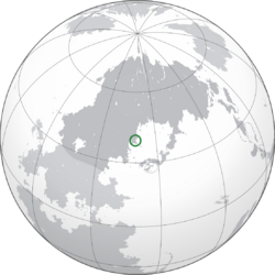
 Location of Hoy Kok (Green) in Hesterath (Dark Grey) | |||||||
| Capital | Hoy Kok (city-state) | ||||||
| Largest village | Santa Sulforte | ||||||
| Official languages and national languages | Qiuese Palon | ||||||
| Ethnic groups (1997) | 65.9% Hoy Kokese 23.7% Qiuese 8.2% Palon 2.2% Others | ||||||
| Religion | 41.3% Terranity 32.8% No religion 16.7% Kaoism 6.7% Weilism 2.5% Others | ||||||
| Demonym(s) | Hoy Kokese | ||||||
| Government | Devolved gubernatorial republic | ||||||
• Governor | Ernesto Ng | ||||||
| Sofia Siu | |||||||
| Paulo Tsang | |||||||
| Legislature | National Council | ||||||
| Establishment | |||||||
| 13 Pusper 1823 | |||||||
| 20 Tebax 1953 | |||||||
| 1 Enero 1980 | |||||||
| 8 Enero 1990 | |||||||
| Area | |||||||
• Total | 4,338 km2 (1,675 sq mi) (XXX) | ||||||
• Water (%) | 8.3% | ||||||
| Population | |||||||
• 1999 estimate | |||||||
• 1998 census | |||||||
• Density | 11,325/km2 (29,331.6/sq mi) (XXX) | ||||||
| GDP (PPP) | 1995 estimate | ||||||
• Total | |||||||
• Per capita | |||||||
| GDP (nominal) | 1999 estimate | ||||||
• Total | |||||||
• Per capita | |||||||
| Gini (1998) | medium (XXX) | ||||||
| HDI (1996) | 0.847 very high | ||||||
| Currency | Hoy Kok Ober (HKO, HKØ) | ||||||
| Time zone | MTS-6 (Hoy Kok Time) | ||||||
| Driving side | right | ||||||
| Calling code | XXX | ||||||
| Internet TLD | .hk | ||||||
| |||||||
Hoy Kok (Palon: Marcanta, Qiuese: 海角, Jyutping: Hoi2 Gok3), officially the State of Hoy Kok, is a country in Hesterath located in the northern Red River Delta by the Horapon Sea. With a population of about 49,126,800 and an area of 11,325 km2 (29,330.1 sq mi), it is the XXX populated region in Gentu.
Formerly a Palon colony, the territory of Palon Hoy Kok was ceded to Palon as a trading post by the Nanchao dynasty in 1823. The colony remained under full Palon rule until 1953 when the Treaty of Beimen granted Hoy Kok a semi-autonomous status. Hoy Kok eventually gained full independence in 1990 in a referendum making it the most recent sovereign state or country with widespread recognition as of 2000. The unique blend of Palon and Qiuese architecture in the country's historic center led to the rise of its tourism industry in 1992.
Originally a sparsely populated network of villages, Hoy Kok has become a strategic port in the Horapon Sea and a top destination for tourists. Hoy Kok's GDP per capita by purchasing power parity is ranked XXX in Gentu. It has a very high Human Development Index, as calculated by the Hoy Kok government, and the XXX-highest life expectancy in Gentu. The territory is highly urbanized; four-fifth of the total land area is built on land reclaimed from the sea.
Etymology
TBA
History
Prehistorical Era and dynastic rule
TBA
Palon colony
TBA
Independence
TBA
Geography
TBA
Climate
TBA
Architecture
TBA
Government
TBA
Administrative divisions
TBA
Demographics
TBA
Economy
TBA
Infrastructure
Transport
TBA
Healthcare
TBA
Education
TBA
Culture
Cuisine
TBA
Sports and recreation
TBA
Media
TBA
Cinema
TBA
Music
TBA


