Hoywako Horapon: Difference between revisions
Philimania (talk | contribs) (Created page with "{{Region_icon_Gentu}} {{Gentu wip}} {{Infobox country |conventional_long_name = Hoywakan State of Horapon |native_name = ''穂本ホ和光'' (Horpongo language|Horpon...") |
Philimania (talk | contribs) mNo edit summary |
||
| (2 intermediate revisions by the same user not shown) | |||
| Line 3: | Line 3: | ||
{{Infobox country | {{Infobox country | ||
|conventional_long_name = Hoywakan State of Horapon | |conventional_long_name = Hoywakan State of Horapon | ||
|native_name = ''穂本ホ和光'' ([[Horpongo language|Horpongo]])<br>''Hohon | |native_name = ''穂本ホ和光'' ([[Horpongo language|Horpongo]])<br>''Hohon howakō'' (Alaricanisation) | ||
|common_name = Horapon | |common_name = Horapon | ||
|image_flag = Hoywako Horapon Flag.png | |image_flag = Hoywako Horapon Flag.png | ||
| Line 78: | Line 78: | ||
}} | }} | ||
'''Hoywako Horapon''' ([[Horpongo language|Horpongo]]: 穂本ホ和光, ''Hohon | '''Hoywako Horapon''' ([[Horpongo language|Horpongo]]: 穂本ホ和光, ''Hohon howakō'') formally the '''Hoywakan State of Horapon''' or simply as '''Horapon''' is an island country in [[Hesterath]] or more specifically in the [[Hesterath lowlands]]. To the north and west, it is bordered by the [[Horapon Sea]]; while to the south and east, it is bordered by the [[Aquamic Ocean]]. Additionally, Hoywako Horapon also possesses a maritime border with [[Ekuchi]] to the north. With a total area of 405,352 km<sup>2</sup> (156,507 sq mi) Hoywako Horapon spans [[Horapon|an archipelago]] of approximately 4000 islands. The four main islands are [[Kitashiro]], [[Chushin]], [[Shimokaido]], and [[Kamikaido]]. [[Minakami]] is the capital as well as the largest city. Other major cities include [[Kenzawa]], [[Renyako]], [[Kyuto]], [[Nishimotoi]], and [[Kaminato]]. | ||
Divided into 17 provinces and 3 autonomous regions, Hoywako Horapon is the X most populated country in Gentu, with a total of 92,582,396 people as of 1999. Due to Horapon's relatively flat terrain, the population is distributed rather evenly with most people living in rural areas than in urban cities, making Hoywako Horapon one of the most agrarian nations in Hesterath. | |||
''TBA'' | ''TBA'' | ||
| Line 86: | Line 88: | ||
[[Category:Countries]] | [[Category:Countries]] | ||
[[Category:Hoywako Horapon]] | [[Category:Hoywako Horapon]] | ||
Latest revision as of 10:48, 12 September 2023
This article is a work in progress. Any information here may not be final as changes are often made to make way for improvements or expansion of lore-wise information about Gentu. Please comment on this article's talk page to share your input, comments and questions. Note: To contribute to this article, contact User:Philimania. |
Hoywakan State of Horapon 穂本ホ和光 (Horpongo) Hohon howakō (Alaricanisation) | |
|---|---|
| Anthem: X | |
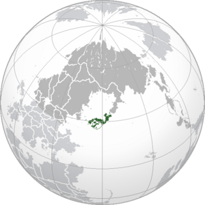
 Location of Horapon (green) in Hesterath (dark grey). | |
| Capital and largest city | Minakami |
| Official languages | Horpongo |
| Recognised regional languages | Kitsunese |
| Ethnic groups (2000) | 91.3% Horaponi 6.4% Kitsunefolk Others |
| Religion (2000) | 64.7% Kaoism 24.3% Tendoism 7.4% No religion 3.6 Others |
| Demonym(s) | Horaponi |
| Government | Unitary Hoywakist one-party state |
| Tano Masuhiro | |
| Kôzuke Doppo | |
| Legislature | National Congress |
| History | |
| c. 100 BCE | |
| 22 Marto 220 CE | |
| 26 Gunyana 1967–2 Pusper 1979 | |
• Hoywako Horapon established | 3 Pusper 1979 |
| 23 Hunyo 1982 | |
| Area | |
• Total | 405,352 km2 (156,507 sq mi) (X) |
• Water (%) | 0.27 |
| Population | |
• 1999 census | |
• Density | 228.4/km2 (591.6/sq mi) (X) |
| GDP (PPP) | 2000 estimate |
• Total | |
• Per capita | |
| GDP (nominal) | 2000 estimate |
• Total | |
• Per capita | |
| Gini (1999) | medium (X) |
| HDI (2000) | high (X) |
| Currency | Jin (銀/ǂ) (HRJ) |
| Time zone | MTS-5 (Horaponi Standard Time) |
| Date format | yyyy/mm/dd |
| Driving side | right |
| Calling code | +75 |
| Internet TLD | .hr |
Hoywako Horapon (Horpongo: 穂本ホ和光, Hohon howakō) formally the Hoywakan State of Horapon or simply as Horapon is an island country in Hesterath or more specifically in the Hesterath lowlands. To the north and west, it is bordered by the Horapon Sea; while to the south and east, it is bordered by the Aquamic Ocean. Additionally, Hoywako Horapon also possesses a maritime border with Ekuchi to the north. With a total area of 405,352 km2 (156,507 sq mi) Hoywako Horapon spans an archipelago of approximately 4000 islands. The four main islands are Kitashiro, Chushin, Shimokaido, and Kamikaido. Minakami is the capital as well as the largest city. Other major cities include Kenzawa, Renyako, Kyuto, Nishimotoi, and Kaminato.
Divided into 17 provinces and 3 autonomous regions, Hoywako Horapon is the X most populated country in Gentu, with a total of 92,582,396 people as of 1999. Due to Horapon's relatively flat terrain, the population is distributed rather evenly with most people living in rural areas than in urban cities, making Hoywako Horapon one of the most agrarian nations in Hesterath.
TBA


