Subarctica: Difference between revisions
Philimania (talk | contribs) mNo edit summary |
Philimania (talk | contribs) mNo edit summary |
||
| (3 intermediate revisions by the same user not shown) | |||
| Line 4: | Line 4: | ||
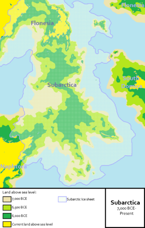
[[File:Subarctica.png|thumb|Map showing the hypothetical extent of Subarctica from now back to the start of the [[Great Sinking]].]] | [[File:Subarctica.png|thumb|Map showing the hypothetical extent of Subarctica from now back to the start of the [[Great Sinking]].]] | ||
''' | '''Subarctica''' was a continent that connected [[Naphtora]] to southern [[Flonesia]], it is currently submerged beneath the [[Southern Ocean]]. It was flooded by rising sea levels around 7000 BCE during the [[Great Sinking]] and the end of the [[Hodiernus Ice Age]]. Geological surveys have suggested that it stretched from what is now the south coast of XXX to what modern day XXX, and the Cape of XXX. The continent was probably a barren wasteland covered by a large {{wp|ice sheet}} known as the [[Subarctic ice sheet]], rising sea levels would gradually reduce the continent to islands of varying sizes that continues the exist to this day. Subarctica got its name from "sub" which means "lower", and "arctic" which relates to the North Pole region. | ||
The archaeological potential of the area was first identified in the mid 20th century, and interest intensified in 1958 when a {{wp|fishing trawler}} operating south of XXX dragged up a barbed antler point that was subsequently dated to a time when the area was | The archaeological potential of the area was first identified in the mid 20th century, and interest intensified in 1958 when a {{wp|fishing trawler}} operating south of XXX dragged up a barbed antler point that was subsequently dated to a time when the area was covered in ice. Vessels have since dragged up remains of mammoths, lions and other animals, and a few prehistoric tools and weapons. As of 1999, international teams are continuing a 2-year investigation into the submerged landscape of Subarctica using new and traditional {{wp|archaeo-geophysical}} techniques and {{wp|molecular biology}}. Evidence gathered allows study of past environments and ecological change. | ||
== Formation == | |||
''TBA'' | |||
== Disappearance == | |||
''TBA'' | |||
== Discovery and investigation == | |||
''TBA'' | ''TBA'' | ||
== In media == | |||
The continent was featured in a 1987 episode of the documentary series called "The Drowned Worlds". | |||
It was also featured in 1995 in "Sunken Continent" investigating the disappearance of the continent and its effect on Gentu. | |||
{{Template:GentuInfo}} | {{Template:GentuInfo}} | ||
[[Category:History of Gentu]] | [[Category:History of Gentu]] | ||
Latest revision as of 16:45, 12 September 2022
This article is a work in progress. Any information here may not be final as changes are often made to make way for improvements or expansion of lore-wise information about Gentu. Please comment on this article's talk page to share your input, comments and questions. Note: To contribute to this article, contact User:Philimania. |

Subarctica was a continent that connected Naphtora to southern Flonesia, it is currently submerged beneath the Southern Ocean. It was flooded by rising sea levels around 7000 BCE during the Great Sinking and the end of the Hodiernus Ice Age. Geological surveys have suggested that it stretched from what is now the south coast of XXX to what modern day XXX, and the Cape of XXX. The continent was probably a barren wasteland covered by a large ice sheet known as the Subarctic ice sheet, rising sea levels would gradually reduce the continent to islands of varying sizes that continues the exist to this day. Subarctica got its name from "sub" which means "lower", and "arctic" which relates to the North Pole region.
The archaeological potential of the area was first identified in the mid 20th century, and interest intensified in 1958 when a fishing trawler operating south of XXX dragged up a barbed antler point that was subsequently dated to a time when the area was covered in ice. Vessels have since dragged up remains of mammoths, lions and other animals, and a few prehistoric tools and weapons. As of 1999, international teams are continuing a 2-year investigation into the submerged landscape of Subarctica using new and traditional archaeo-geophysical techniques and molecular biology. Evidence gathered allows study of past environments and ecological change.
Formation
TBA
Disappearance
TBA
Discovery and investigation
TBA
In media
The continent was featured in a 1987 episode of the documentary series called "The Drowned Worlds".
It was also featured in 1995 in "Sunken Continent" investigating the disappearance of the continent and its effect on Gentu.

