Aquamic Ocean: Difference between revisions
Philimania (talk | contribs) (Created page with "{{Region_icon_Gentu}} {{Gentu wip}} {{Infobox body of water | name = Aquamic Ocean | image = Aquamic ortho.png | caption = Extent of the...") |
Philimania (talk | contribs) |
||
| (5 intermediate revisions by the same user not shown) | |||
| Line 18: | Line 18: | ||
}} | }} | ||
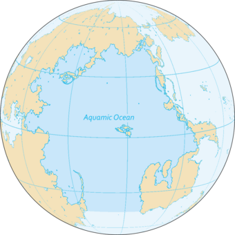
The '''Aquamic Ocean''', also known as the '''Megalon Ocean''' by the Ancient Pylosan and Calidum, is [[Gentu]] XXX largest ocean. It covers a surface area of {{Convert|65106141|km2|abbr=on}} or approximately 7.08% of the water on Gentu's surface. | The '''Aquamic Ocean''', also known as the '''Megalon Ocean''' by the Ancient Pylosan and Calidum, is [[Gentu]] XXX largest ocean. It covers a surface area of {{Convert|65106141|km2|abbr=on}} or approximately 7.08% of the water on Gentu's surface. It is bordered by [[Hesterath]] to the north and northwest; [[Oranland]] and [[Naphtora]] to the west; [[Flonesia]] to the east; and the [[Southern Ocean]] to the south. Along its core, the Aquamic Ocean has some large marginal or regional seas such as the [[Horapon Sea]], the [[Nanhai Sea]], the [[White Sea (Gentu)|White Sea]], the [[Gulf of Urgan]], and the [[Gulf of Tevrick]]. | ||
== Etymology == | |||
''TBA'' | |||
== Geography == | |||
With a surface area of 65,106,141 km<sup>2</sup> (25,137,622 sq mi), the Aquamic Ocean consists of an estimate 7.08% of Gentu's surface water and its volume is estimated to be around 213,678,000 km<sup>3</sup> (51,264,000 cu mi). The Aquamic's average depth is 3,282 m (10,768 ft) although the deepest point is 6,291 m (20,640 ft) in the [[Mëisy Trench]]. To the south, the Aquamic is bordered by the [[Southern Ocean]] as well as [[Aralona]]; in the west is [[Naphtora]] (X countries), the [[Ingentric Ocean]] through the [[Zestoric Sea]], [[Horapon]], and the [[Hesterath lowlands]]; in the north is bordered by [[Eudocia]]; and to the west is northern [[Flonesia]] including the nations of X. | |||
Marginal seas, gulfs, bays and straits of the Aquamic Ocean includes the Horapon Sea, the Nanhai Sea, the White Sea, the Gulf of Urgan, the Gulf of Tevrick, X... | |||
''TBA'' | |||
== Climate == | |||
''TBA'' | |||
== Oceanography == | |||
''TBA'' | |||
== Marine life == | |||
{{see also|List of endangered species in the Aquamic}} | |||
[[File:16x9 M.jpg|thumb|left|A school of {{wp|tuna}}s of the coast of [[Mareasia]].]] | |||
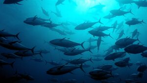
In the tropical parts of the Aquamic, the ocean hosts a large concentration of {{wp|phytoplankton}} blooms in the summer and early autumn seasons due to southerly currents in the [[North Nullaric Ocean]]. These currents leads to a strong coastal and open ocean upwelling, which introduces nutrients into the upper zones where sufficient light is available for {{wp|photosynthesis}} and phytoplankton production. These phytoplankton blooms support the marine ecosystem, as the base of the marine food web, and eventually the larger fish species. The Aquamic Ocean accounts for the X-largest share of the most economically valuable {{wp|tuna}} catch. Its fish are of great and growing importance to the bordering countries for domestic consumption and export. Fishing fleets from [[Qiuha]], X, and X also exploit the Aquamic Ocean, mainly for shrimp and tuna. | |||
Research indicates that increasing ocean temperatures are taking a toll on the marine ecosystem. A study on the phytoplankton changes in the Aquamic Ocean indicates a decline of up to 35% in the marine plankton in the ocean, during the past six decades. The tuna catch rates have also declined 50–95% during the past half-century, mostly due to increased industrial fisheries, with the ocean warming adding further stress to the fish species. | |||
Approximately 80% of the Aquamic Ocean is open ocean and includes six large marine ecosystems: the [[Horapon Current]], [[East Naphtoran Coastal Current]], [[Gulf of Tevrick]], [[White Sea (Gentu)|White Sea]], [[South Gaben Shelf]], and the [[Nanhai-Urgan System]]. Coral reefs, sea grass beds, and mangrove forests (which cover X km<sup>2</sup> in the Aquamic region) are the most productive ecosystems of the Aquamic Ocean. Coastal areas produces 20 tons km<sup>3</sup> of fish. These areas, however, are also being urbanised with populations often exceeding several thousand people per square kilometre and fishing techniques become more effective and often destructive beyond sustainable levels while the increase in sea surface temperature spreads coral bleaching. | |||
''TBA'' | |||
== Biodiversity == | |||
''TBA'' | |||
== Geology == | |||
''TBA'' | |||
== History == | |||
''TBA'' | ''TBA'' | ||
| Line 24: | Line 67: | ||
{{Template:GentuInfo}} | {{Template:GentuInfo}} | ||
[[Category:Aquamic Ocean]] | [[Category:Aquamic Ocean]] | ||
[[Category:Oceans in Gentu]] | |||
Latest revision as of 12:46, 20 October 2022
This article is a work in progress. Any information here may not be final as changes are often made to make way for improvements or expansion of lore-wise information about Gentu. Please comment on this article's talk page to share your input, comments and questions. Note: To contribute to this article, contact User:Philimania. |
| Aquamic Ocean | |
|---|---|
 Extent of the Aquamic Ocean | |
| Location | Hesterath lowlands, North and East Hesterath, East Naphtora, Flonesia |
| Type | Ocean |
| Max. length | 212,943 km (132,317 mi) (North Hesterath to Southern Ocean) |
| Max. width | 156,905 km (97,496 mi) (East Naphtora to East Hesterath) |
| Surface area | 65,106,141 km2 (25,137,622 sq mi) |
| Average depth | 3,282 m (10,768 ft) |
| Max. depth | 6,291 m (20,640 ft) (Mëisy Trench) |
| Shore length1 | 250,217 km (155,478 mi) |
| Settlements | Hoy Kok, Uraka, Herffing, Sherley, Dawlun |
| 1 Shore length is not a well-defined measure. | |
The Aquamic Ocean, also known as the Megalon Ocean by the Ancient Pylosan and Calidum, is Gentu XXX largest ocean. It covers a surface area of 65,106,141 km2 (25,137,622 sq mi) or approximately 7.08% of the water on Gentu's surface. It is bordered by Hesterath to the north and northwest; Oranland and Naphtora to the west; Flonesia to the east; and the Southern Ocean to the south. Along its core, the Aquamic Ocean has some large marginal or regional seas such as the Horapon Sea, the Nanhai Sea, the White Sea, the Gulf of Urgan, and the Gulf of Tevrick.
Etymology
TBA
Geography
With a surface area of 65,106,141 km2 (25,137,622 sq mi), the Aquamic Ocean consists of an estimate 7.08% of Gentu's surface water and its volume is estimated to be around 213,678,000 km3 (51,264,000 cu mi). The Aquamic's average depth is 3,282 m (10,768 ft) although the deepest point is 6,291 m (20,640 ft) in the Mëisy Trench. To the south, the Aquamic is bordered by the Southern Ocean as well as Aralona; in the west is Naphtora (X countries), the Ingentric Ocean through the Zestoric Sea, Horapon, and the Hesterath lowlands; in the north is bordered by Eudocia; and to the west is northern Flonesia including the nations of X.
Marginal seas, gulfs, bays and straits of the Aquamic Ocean includes the Horapon Sea, the Nanhai Sea, the White Sea, the Gulf of Urgan, the Gulf of Tevrick, X...
TBA
Climate
TBA
Oceanography
TBA
Marine life
In the tropical parts of the Aquamic, the ocean hosts a large concentration of phytoplankton blooms in the summer and early autumn seasons due to southerly currents in the North Nullaric Ocean. These currents leads to a strong coastal and open ocean upwelling, which introduces nutrients into the upper zones where sufficient light is available for photosynthesis and phytoplankton production. These phytoplankton blooms support the marine ecosystem, as the base of the marine food web, and eventually the larger fish species. The Aquamic Ocean accounts for the X-largest share of the most economically valuable tuna catch. Its fish are of great and growing importance to the bordering countries for domestic consumption and export. Fishing fleets from Qiuha, X, and X also exploit the Aquamic Ocean, mainly for shrimp and tuna.
Research indicates that increasing ocean temperatures are taking a toll on the marine ecosystem. A study on the phytoplankton changes in the Aquamic Ocean indicates a decline of up to 35% in the marine plankton in the ocean, during the past six decades. The tuna catch rates have also declined 50–95% during the past half-century, mostly due to increased industrial fisheries, with the ocean warming adding further stress to the fish species.
Approximately 80% of the Aquamic Ocean is open ocean and includes six large marine ecosystems: the Horapon Current, East Naphtoran Coastal Current, Gulf of Tevrick, White Sea, South Gaben Shelf, and the Nanhai-Urgan System. Coral reefs, sea grass beds, and mangrove forests (which cover X km2 in the Aquamic region) are the most productive ecosystems of the Aquamic Ocean. Coastal areas produces 20 tons km3 of fish. These areas, however, are also being urbanised with populations often exceeding several thousand people per square kilometre and fishing techniques become more effective and often destructive beyond sustainable levels while the increase in sea surface temperature spreads coral bleaching.
TBA
Biodiversity
TBA
Geology
TBA
History
TBA


