Erdara: Difference between revisions
mNo edit summary |
mNo edit summary |
||
| Line 223: | Line 223: | ||
|} | |} | ||
[[Category:Regions of Gaia]] | |||
{{Template:Gaia}} | {{Template:Gaia}} | ||
Latest revision as of 03:30, 19 February 2020
Erdara Erdara (Hesurian) | |
|---|---|
 | |
| Languages | Official languages Hesurian Almic Hytek Juznik Recognized regional languages Lesinic Sigairish Similian |
| Demonym(s) | Erdaran |
| Composition | |
| Population | |
• Estimate | 183,634,800 |
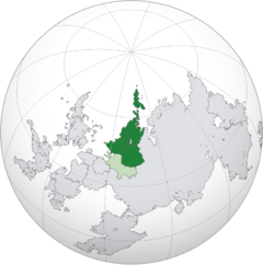
Erdara (/ˈɜrˌdærə/; Hesurian: Erdara [ʔɛɐ̯ˈdaːʁa] (Mascyllary), [ɛrˈdaːra], Hytek, Juznik: Ragucija) is a geographic continent and cultural region. By common definition, the term Erdara covers the countries of Alriika, Hytekia, Juznia, Lilienburg, Mascylla, and Krumlau. These nations are linked with strong historical, cultural, and political ties, however in a larger perspective, Erdara also sometimes refers to the countries of Dulebia and X mainly due to their significant economic and historical connections to the region.
Erdara as a peninsula is bordered by the X to the north, the X to the west, the White Sea to the east, and the Kyralov Sea to the north-east, while the southern border is variously defined. With a population of approximately 183,634,800 people in 2018, and an area of x square kilometres (x sq mi), it is one of the most densely populated regions on Gaia. The Erdaran climate is affected significantly by warm oceanic currents which bring milder winters for its latitude, as well as humidity to its inland plains.
Etymology
History
Ragucin Empire
Geography
Politics
Erdaran Union
Current leaders
Dorothea I
Queen Empress of Mascylla
since 2015Talis Briksnis
President of Hytekia
since 2016Helena Weissmann
Mayor of Lilienburg
since 2017Saulius Gudaitis
President of Juznia
since 2015Louise von Thalmark
Archduchess of Krumlau
since 2013
Thomas Falkner
Prime Minister of Mascylla
since 2016Magnus Seglins
Chancellor of Hytekia
since 2016Hermann Thaler
Chancellor of Lilienburg
since 2016Ieva Kleizaitė
Prime Minister of Juznia
since 2017Natalia Wojtek
Chancellor of Krumlau
since 2018
Economies
Culture
Sovereign states
| Alriika | Hytekia | Juznia | Lilienburg | Mascylla | Krumlau | |
|---|---|---|---|---|---|---|
| Coat of arms | 
|
|||||
| Flag | ||||||
| Capital | Sangashámman | Krasno | Višnevas | Lilienburg City | Königsreh | Rakonitz |
| Independence | 1 January 1900 | 27 October 1989 | 27 October 1989 | 16 April 1881 | 23 May 1793 | 21 March 1494 |
| Political system | Directorial republic | Unitary one-party semi-presidential republic | Unitary parliamentary republic | Unitary parliamentary republic with elements of syndicalism and direct democracy |
Federal constitutional monarchy | Federal parliamentary monarchy |
| Parliament | Sáhka | National Assembly of Hytekia | Taryba | Stadtshaus | Reichsrat | Bundesrat |
| Current head of state | Kirste Frosch | Magnus Seglins | Saulius Gudaitis | Helena Weissmann | Dorothea I | Louise von Thalmark |
| Population (census) | 299,124 | 36,826,625 | 14,015,335 | 607,183 | 38,972,039 | 43,941,015 |
| Area | 15,581 km2 | 441,878km2 | 168,651 km2 | 3,546 km2 | 338,424 km2 | 1,004,344 km2 |
| Density | 19/km2 | 80/km2 | 83/km2 | 171/km2 | 115/km2 | 44/km2 |
| Currency | Ruhta (ᚱ) | Nauda (HYN) | Dukatas (JZD) | Mark (LBM) | Karning (KN) | Krone (KRN) |
| GDP (nominal) total (2018) | $11.94 billion | $183.0 billion | $127.6 billion | $24.4 billion | $1.020 trillion | $1.772 trillion |
| GDP (nominal) per capita (2018) | $38,010 | $6,016 | $9,107 | $40,193 | $35,219 | $40,334 |
| HDI (2018) | 0.892 (Very high) | 0.797 (High) | 0.802 (Very high) | 0.897 (Very high) | 0.938 (Very high) | 0,907 (Very High) |
| Internet TLD | .al | .hy | .jz | .li | .mc | .kr |
| Calling code | +39 | +91 | +94 | +328 | +43 | +50 |


