Teudallum: Difference between revisions
| Line 73: | Line 73: | ||
| [[Cadenza]] | | [[Cadenza]] | ||
| Khade | | Khade | ||
|- | |||
| style="text-align:center;"| {{flagicon|Cassonne}} | |||
| style="text-align:center;"| {{Coat of arms|Balearic Islands|text=none}} | |||
| [[Cassonne]] | |||
| style="text-align:right;"| 1,562,200 | |||
| style="text-align:right;"| | |||
| style="text-align:right;"| | |||
| [[Citadelle Royán]] | |||
| Cassonne | |||
|- | |- | ||
| style="text-align:center;"| {{flagicon|Dungeyland}} | | style="text-align:center;"| {{flagicon|Dungeyland}} | ||
| Line 111: | Line 120: | ||
|- | |- | ||
| style="text-align:center;"| {{flagicon|Monsa}} | | style="text-align:center;"| {{flagicon|Monsa}} | ||
| style="text-align:center;"| {{Coat of arms| | | style="text-align:center;"| {{Coat of arms|Monaco|text=none}} | ||
| [[Monsa]] | | [[Monsa]] | ||
| style="text-align:right;"| | | style="text-align:right;"| 467.63 | ||
| style="text-align:right;"| | | style="text-align:right;"| 78,450 | ||
| style="text-align:right;"| | | style="text-align:right;"| 179.8 | ||
| [[Monsa (City)]] | | [[Monsa (City)|Monsa]] | ||
| Monsa | | Monsa | ||
|- | |||
| style="text-align:center;"| {{flagicon|Morroseta}} | |||
| style="text-align:center;"| [[File:Coat_of_Arms_of_Morroseta.png|25px]] | |||
| [[Morroseta]] | |||
| style="text-align:right;"| | |||
| style="text-align:right;"| 2,708,339 | |||
| style="text-align:right;"| 1,143 | |||
| [[A Gracia]] | |||
| República Morroseta | |||
|- | |- | ||
| style="text-align:center;"| {{flagicon|Slovertia}} | | style="text-align:center;"| {{flagicon|Slovertia}} | ||
Revision as of 01:15, 29 December 2020
 | |
| Area | 29,286,100 km2 |
|---|---|
| Population | 2,084,607,531 (+ a bunch of missing countries) |
| Population density | 71.2/km2 (c. 184/sq mi) |
| Demonym | Teudallic |
| Countries | 25 |
| Languages | List of languages |
| Time zones | UTC-1 to UTC+6 |
| Largest cities | |
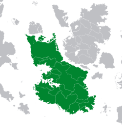
Teudallum is an insular continent in western Astyria. It is divided from its more northernly neighbour, Lorecia, by the Putin Strait. It is bounded to the north by the Mederano Sea, to the south-east by the Mare Ferum, to the west by the Sea of Jajich and to the south by the Bigblue Ocean.
It is Astyria's second largest continent by area, after Hesperidesia, covering approximately 29,260,000 square kilometres (11,307,000 sq mi). If the Woodsteasian Isles, which lie on the Teudallic continental shelf, are included, it is Astyria's largest continent, at 30,670,200 square kilometres. Of Teudallum's 25 countries, Nikolia is the largest while Monsa is its smallest.
Teudallum is an extremely culturally diverse continent, with many of its peoples holding strong national identities. Despite this, it has been historically characterised by close ties and the intermixing of cultural ideas, perhaps most notably in the Ethlorek migrations from eastern Lorecia to modern Trellin.
Together with Lorecia, Teudallum constitutes the Astyrian 'Old World', as the majority of its landmass has been settled since prehistory. Only the equatorial and desert regions of the continent remained stateless into the early modern era. The west Teudallic nations, such as Berique, Cadenza and Dungeyland, presided over significant colonial empires, with their influence reaching across the region; these three nations are the last to hold overseas territories, excluding Northern ViZion which lies in Lorecia. Territories of non-Teudallic countries on the continent include Al-Raha, a possession of Riysa, and Sycoon, a dominion of Kylarnatia.
History
Prehistory
Teudallum has been settled since prehistory. Indigenous peoples have been shown to have inhabited what is now Trellin since at least 18,000 BC, initially as hunter-gatherers in the vast rainforests thereof before transitioning to an agricultural culture around 2,200 BC.
Antiquity
Middle Ages
Early Modern Period
20th century to present day
Geography
Climate
Geology
Flora
Fauna
Politics
List of states and territories
The list below includes the countries and territories in Teudallum.
| Flag | Arms | Name | Area (km) | Population | Population density (per km) | Capital | Name(s) in official language(s) |
|---|---|---|---|---|---|---|---|
| Berique | 635,372 | ? | ? | ? | Berique | ||
| Cadenza | 5,183.94 | 1,506,583 | 290.63 | Cadenza | Khade | ||
| Cassonne | 1,562,200 | Citadelle Royán | Cassonne | ||||
| Dangish Empire | 1,323,452 | 1,883,260,183 | 1423 | New London | Dangish Empire | ||
| Great Nortend | 190,542 | 32,102,002 | 168.48 | Lendert-with-Cadell | Great Nortend | ||
| Nikolia | 6,182,800 | 725,364,156 | 117 | Carigrad | Николија | ||
| Trellin | 1,914,936.1 | 229,142,864 | 118.7 | Mar'theqa | Trelli'ka | ||
| Monsa | 467.63 | 78,450 | 179.8 | Monsa | Monsa | ||
| Template:Country data Morroseta | File:Coat of Arms of Morroseta.png | Morroseta | 2,708,339 | 1,143 | A Gracia | República Morroseta | |
| Slovertia | 43,791 | 7,433,371 | Brativas | Slovertskó | |||
| Template:Country data Equinoxiale | Equinoxiale | 91 | 64.850 | 712 | Marqueville | Compagnié Commercialé de Équinoxiale |