Paloa: Difference between revisions
Philimania (talk | contribs) m (→Geography) |
Philimania (talk | contribs) m (→Geography) |
||
| Line 155: | Line 155: | ||
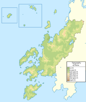
[[File:Paloa Topo.png|thumb|Topograaphic map of Paloa.]] | [[File:Paloa Topo.png|thumb|Topograaphic map of Paloa.]] | ||
The territory of Paloa consists of an area on the Hesterlon Peninsula sometimes referred to as ''the mainland'' by most Palon people, and an island and | The territory of Paloa consists of an area on the Hesterlon Peninsula sometimes referred to as ''the mainland'' by most Palon people, and an island and archipelago in the Ingentric Ocean: the island of Farata and the archipelago of New Roque. Paloa has a total land area of 360,087.9 km<sup>2</sup> (139,030.7 sq mi) making it the XXX largest in Oranland and the XXX in Gentu. | ||
Mainland Paloa is split by its 2 main river, the [[Leitao River]] and the [[Alemán]], both of which flows from XXX and disgorges into their own respective estuaries, before escaping into the Ingentric. The northern landscape is mountainous towards the exterior with large plains towards the interior, the central landscape meanwhile consists of a mixture of flat plains and rolling hills, whereas the south, including the islands and archipelago region, is characterized by rolling plains with a few mountain ranges dotted about the region. Paloa's highest peak is [[Mount Subir]] in the [[Surmonté mountains]] which measures 897 m (2,942.9 ft) while to lowest point is the [[Afundar Depression]] which sits at 104 m (341 ft) below sea level on the [[Afundar Peninsula]] in central Paloa. The island and archipelago of Farata and New Roque are scattered within the Ingentric Ocean: Farata as well as New Roque is situated along a range formed by {{wp|plate tectonic|in-plate}} {{wp|hotspot (geology)|hotspot}} geology. Geologically, these islands were formed by volcanic and seismic events. The last terrestrial volcanic eruption occurred in 1848 ([[Matarmorrer]]) and minor earthquakes occur sporadically, usually of low intensity. | Mainland Paloa is split by its 2 main river, the [[Leitao River]] and the [[Alemán]], both of which flows from XXX and disgorges into their own respective estuaries, before escaping into the Ingentric. The northern landscape is mountainous towards the exterior with large plains towards the interior, the central landscape meanwhile consists of a mixture of flat plains and rolling hills, whereas the south, including the islands and archipelago region, is characterized by rolling plains with a few mountain ranges dotted about the region. Paloa's highest peak is [[Mount Subir]] in the [[Surmonté mountains]] which measures 897 m (2,942.9 ft) while to lowest point is the [[Afundar Depression]] which sits at 104 m (341 ft) below sea level on the [[Afundar Peninsula]] in central Paloa. The island and archipelago of Farata and New Roque are scattered within the Ingentric Ocean: Farata as well as New Roque is situated along a range formed by {{wp|plate tectonic|in-plate}} {{wp|hotspot (geology)|hotspot}} geology. Geologically, these islands were formed by volcanic and seismic events. The last terrestrial volcanic eruption occurred in 1848 ([[Matarmorrer]]) and minor earthquakes occur sporadically, usually of low intensity. | ||
Revision as of 04:53, 1 June 2022
This article is a work in progress. Any information here may not be final as changes are often made to make way for improvements or expansion of lore-wise information about Gentu. Please comment on this article's talk page to share your input, comments and questions. Note: To contribute to this article, contact User:Philimania. |
Republic of Paloa República de Paloa (Palon) | |||||||
|---|---|---|---|---|---|---|---|
| Motto: Vivemos livres ("We live free") | |||||||
| Anthem: XXX | |||||||
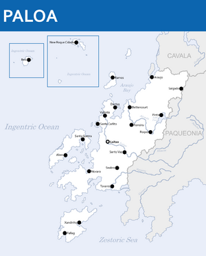 Map of Paloa | |||||||
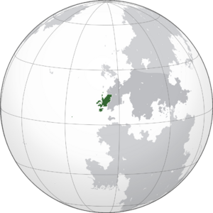 Location of Paloa (Green) in Oranland (Dark Grey) | |||||||
| Capital | Leitao | ||||||
| Largest city | Araujo | ||||||
| Official languages | Palon | ||||||
| Recognised regional languages | Hestandan | ||||||
| Ethnic groups (2000) | |||||||
| Religion (1999) |
| ||||||
| Demonym(s) | Palon | ||||||
| Government | Unitary semi-presidential republic | ||||||
| Filipa Maciel | |||||||
| Sebastião Rebelo | |||||||
| Legislature | Congress of Paloa | ||||||
| Assento | |||||||
| Baixo Assembly | |||||||
| History | |||||||
| c. 100 BCE | |||||||
| 12 Tebax 1102-3 Pusper 1105 | |||||||
| 23 Hunyo 1555 | |||||||
| 26 Pulungana 1843-9 Kunnen 1845 | |||||||
| 1 Memesa 1848-18 Gunyana 1852 | |||||||
• Republic | 31 Enero 1957 | ||||||
| 22 Enero 1960 | |||||||
| Area | |||||||
• Total | 360,087.9 km2 (139,030.7 sq mi) (XXX) | ||||||
• Water (%) | 0.4 | ||||||
| Population | |||||||
• 1997 estimate | |||||||
• 1999 census | |||||||
• Density | 96.9/km2 (251.0/sq mi) (XXX) | ||||||
| GDP (PPP) | 1999 estimate | ||||||
• Total | |||||||
• Per capita | |||||||
| GDP (nominal) | 2000 estimate | ||||||
• Total | |||||||
• Per capita | |||||||
| Gini (2000) | low (XXX) | ||||||
| HDI (1999) | very high (XXX) | ||||||
| Currency | Palon Ober (PØ) (PLO) | ||||||
| Time zone | MTS-9 (West Oranland Time) MTS-11 (East Ingentric Time) MTS-12 (New Roque Time) | ||||||
| Date format | dd-mm-yyyy | ||||||
| Driving side | right | ||||||
| Calling code | XXX | ||||||
| Internet TLD | .pl | ||||||
| |||||||
Paloa, officially the Republic of Paloa (Palon: República de Paloa), is a country whose mainland is located on the Hesterlon Peninsula in western Oranland, and whose territory also include the New Roque archipelago and the island of Farata. Paloa is bordered by XXX to the east, Cavala to the north, the Ingentric Ocean to the west, and the Zestoric Sea to the south. Leitao is the capital city of Paloa while Araujo is the largest city.
- History
Palon has left a profound cultural, architectural and linguistic influence across the globe, with a legacy of around XXX Palon speakers around the world. It is a developed country with an advanced economy and high living standards. Additionally, it ranks highly in peacefulness, democracy, freedom, stability, social progress, and prosperity. A member of the Union of Realms, and the Oranland Trade Union, Palon was also one of the founding members of ARDO, and the Community of Palon Language Countries.
History
Prehistorical Paloa
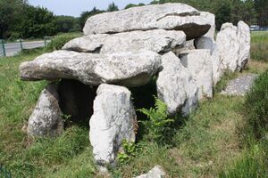
The region of what is now Paloa was settled by Dordon tribes, giving origin to peoples such as the Veragons and XXX which eventually evolved into the modern Palon people. Present-day Paloa was inhabited by Homo rectus before they went extinct around 300,000–30,000 BP and then by Homo validus and Homo captiosus, both species roaming the border-less region of the Hesterlon Peninsula until the extinction of the Homo validus c. 7,000–6,000 BCE after which Homo captiosus remained. These were subsistence societies and although they did not establish prosperous settlements, they did form organized societies. Paloa during the Novalithic experimented with domestication of herding animals, the raising of some cereal crops and fluvial or marine fishing. Metallurgy later appeared during the middle of the 3rd millennium BCE. Paloa, like its neighbours Cavala and XXX, possesses numerous megalithic sites with 435 known sites as of 2000, some well knowns of which are the Castro stones near present day Pinta, and the Santo Vaz dolmen near Santo Vaz.
Ancient and Antiquity Era
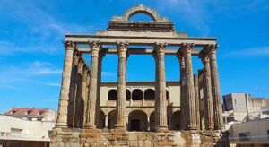
Based on the Calidum chronicles about the Veragon peoples and the interpretation of the abundant archaeological remains throughout the southern and central half of Paloa and some of XXX in XXX during the Ancient Era, it is possible to infer that there was a matriarchal society, with a religious aristocracy. The figures of maximum authority were the chieftain, of military type and with authority in his tribe, and the druid, mainly referring to medical and religious functions that could be common to several tribes. The first documentary references to tribal society in Paloa are provided by chroniclers of Calidum military campaigns such as Apui, Stephinates and XXX among others, about the social organization, and describing the inhabitants of these territories, the Veragese tribes of southern Paloa, also known as the Amossan are described as: "A group of barbarians who spend the day fighting and the night eating, drinking and dancing under the moon". There were other similar tribes and subgroups, chief among them were the Boromans; the core area of these people lay in central Paloa, while numerous other related tribes existed such as the Farovans, Cyconts and Aeroans.
The Calidum Empire first settled in Paloa some time around 1300 BCE. However, they were expelled from the region around the 11th century BCE by the Veragon tribes. Beginning from the 11th century BCE, the region would stay relatively isolated from the rest of the Zestoric until the late 4th century BCE when the Pylosan Empire colonized the region resulting in the founding of several cities that still remains to this day such as Tahu (Tavares), Nun-oni (Novaro), and Donkor (Dantas).
After the 2nd Zestoric War in 1 CE, Pylosan colonies including those in Paloa were assimilated into the Alarican Empire. However, Alarican control over the region suffered a setback in 3 CE when a rebellion began in the south. The Farovans and remnants of the Pylosan army under the leadership of Glycon, a former Pylosan general, fought for control over the southern Hesterlon Peninsula. Alarico sent numerous legions and its best generals to Paloa to quell the rebellion, in 10 CE, Glycon was killed in battle near Tavares resulting in a power struggle among Glycon's allies allowing Alarico to put an end to the rebellion in 11 CE.
In 129, Alarico conquered the rest of the Hesterlon Peninsula, installing a colonial regime over the region. Several works of engineering, such as baths, temples, bridges, roads, circuses, theatres and laymen's homes are preserved throughout the country. Coins, as well as numerous pieces of ceramics, were also found. Contemporary historians include Caninius (c. 360–422) and Oppius (c. 417–481), who detailed the final years of Alarican control over Paloa and the rebellions and uprisings led by the Palon people.
Alarican Empire
TBA
Darodan Empire
TBA
Palon Revolution
TBA
Colonial Era
TBA
Contemporary Age
TBA
Geography
The territory of Paloa consists of an area on the Hesterlon Peninsula sometimes referred to as the mainland by most Palon people, and an island and archipelago in the Ingentric Ocean: the island of Farata and the archipelago of New Roque. Paloa has a total land area of 360,087.9 km2 (139,030.7 sq mi) making it the XXX largest in Oranland and the XXX in Gentu.
Mainland Paloa is split by its 2 main river, the Leitao River and the Alemán, both of which flows from XXX and disgorges into their own respective estuaries, before escaping into the Ingentric. The northern landscape is mountainous towards the exterior with large plains towards the interior, the central landscape meanwhile consists of a mixture of flat plains and rolling hills, whereas the south, including the islands and archipelago region, is characterized by rolling plains with a few mountain ranges dotted about the region. Paloa's highest peak is Mount Subir in the Surmonté mountains which measures 897 m (2,942.9 ft) while to lowest point is the Afundar Depression which sits at 104 m (341 ft) below sea level on the Afundar Peninsula in central Paloa. The island and archipelago of Farata and New Roque are scattered within the Ingentric Ocean: Farata as well as New Roque is situated along a range formed by in-plate hotspot geology. Geologically, these islands were formed by volcanic and seismic events. The last terrestrial volcanic eruption occurred in 1848 (Matarmorrer) and minor earthquakes occur sporadically, usually of low intensity.
Paloa's territorial waters, a sea zone over which Paloa have special rights over the exploration and use of marine resources, has 3,776,946 km2. This is the XXX largest territorial waters of Oranland and the XXX largest in Gentu.
Climate
The Climate of Paloa is characterised by an oceanic climate to the north and central region, and a Zestoric climate in the south and in Farata and the New Roque archipelago.
TBA
Environment
TBA
Administrative divisions
TBA
Major cities
TBA
Politics and government
TBA
Military
TBA
Foreign relations
TBA
Economy
TBA
Tourism
TBA
Energy
TBA
Industry
TBA
Infrastructure
TBA
Transport
TBA
Science and technology
TBA
Demographics
TBA
Language
TBA
Education
TBA
Religion
TBA
Culture
TBA
Music and art
TBA
Fashion
TBA
Philosophy
TBA
Literature
TBA
Architecture
TBA
Cuisine
TBA
Sports
TBA
Media
TBA


