Jukasa: Difference between revisions
Philimania (talk | contribs) |
Philimania (talk | contribs) m (→Geography) |
||
| Line 164: | Line 164: | ||
[[File:A forest scene of Xibin town,Youxi county.JPG|thumb|300px|The [[Jukasan subtropical evergreen forest]] is one of the largest in Gentu.]] | [[File:A forest scene of Xibin town,Youxi county.JPG|thumb|300px|The [[Jukasan subtropical evergreen forest]] is one of the largest in Gentu.]] | ||
Jukasa is located in [[Plevapotamia]] and consists of a total of 1,012,295 km<sup>2</sup> (390,849 sq mi) of land 0.05% of which is water. This makes Jukasa the X-largest country in Gentu. To the west and north, Jukasa is bordered by [[Neragon]] through X, as well as the [[Iserlonic Gulf]] and the [[Ingentric Ocean]]. To the east by [[Norland]]. To the south by [[Sissaland]], [[West Farhad]] and [[Lake Exore]]. The topogaphy of Jukasa is relatively flat with little elevation, having an average height of {{cvt|35|m|ft}} above sea level. The highest point is [[Point Hondor]] (258 m) near [[Ameen]]. The main river of Jukasa as the [[Exore River]], running from Lake Exore and emptying into the [[Exore Estuary]]. Additionally, it has supported human civilisation such as [[Iserlon]] in Jukasa since the [[Ancient Era]]. | Jukasa is located in [[Plevapotamia]] and consists of a total of 1,012,295 km<sup>2</sup> (390,849 sq mi) of land 0.05% of which is water. This makes Jukasa the X-largest country in Gentu. The country also has {{cvt|51010|km|mi}} of coastline. To the west and north, Jukasa is bordered by [[Neragon]] through X, as well as the [[Iserlonic Gulf]] and the [[Ingentric Ocean]]. To the east by [[Norland]]. To the south by [[Sissaland]], [[West Farhad]] and [[Lake Exore]]. The topogaphy of Jukasa is relatively flat with little elevation, having an average height of {{cvt|35|m|ft}} above sea level. The highest point is [[Point Hondor]] (258 m) near [[Ameen]]. The main river of Jukasa as the [[Exore River]], running from Lake Exore and emptying into the [[Exore Estuary]]. Additionally, it has supported human civilisation such as [[Iserlon]] in Jukasa since the [[Ancient Era]]. | ||
Jukasa is also home to the largest {{wp|subtropical evergreen forests}} on Gentu, spanning roughly {{cvt|826290|km|mi}} in the northern region, with some parts stretching into neighbouring [[Norland]]. A large portion of southern Jukasa's terrain consists of rolling plains whilst the coastline is sandy. Although once extensively forested, today Jukasa largely consists of {{wp|arable land}}. | Jukasa is also home to the largest {{wp|subtropical evergreen forests}} on Gentu, spanning roughly {{cvt|826290|km|mi}} in the northern region, with some parts stretching into neighbouring [[Norland]]. A large portion of southern Jukasa's terrain consists of rolling plains whilst the coastline is sandy. Although once extensively forested, today Jukasa largely consists of {{wp|arable land}}. | ||
=== Climate === | === Climate === | ||
Revision as of 10:10, 7 December 2022
This article is a work in progress. Any information here may not be final as changes are often made to make way for improvements or expansion of lore-wise information about Gentu. Please comment on this article's talk page to share your input, comments and questions. Note: To contribute to this article, contact User:Philimania. |
Republic of Jukasa | |||||||
|---|---|---|---|---|---|---|---|
| Motto: "ᠠᠷᠠᠳ ᠲᠦᠮᠡᠨ ᠦ ᠰᠠᠶᠢᠨ ᠰᠠᠶᠢᠬᠠᠨ ᠤ ᠲᠥᠯᠥᠭᠡ" "For the good of the people" | |||||||
| Anthem: X | |||||||
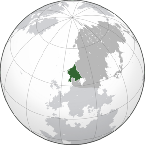
 Location of Jukasa (Green) in Hesterath (Dark Grey) | |||||||
| Capital | Sesay | ||||||
| Largest city | Iren | ||||||
| Official languages | Jaksan | ||||||
| Recognised national languages | Sissatic | ||||||
| Recognised regional languages | Juksan · Norish | ||||||
| Ethnic groups (2000) | 76.8% Jaksan 13.6% Sissatic 5.1% Juksan 3.3% Norish 1.2% Others | ||||||
| Religion (1999) | 94% Plecan 4.7% No religion 1.3% Others | ||||||
| Demonym(s) | Jukasan | ||||||
| Government | Unitary semi-presidential republic | ||||||
| Temujin Khubilai | |||||||
| Dorgene Shigi-Qutuqu | |||||||
| Chimbai Tugtemur (acting) | |||||||
| Khorihilemunaisi Khadagan | |||||||
| Legislature | Jukasan National Assembly | ||||||
| Independence from the Omaran Empire | |||||||
| 1934 Hunyo 30 | |||||||
| 1941 Pusper 4–1941 Pusper 23 | |||||||
| 1941 Pusper 29 | |||||||
| 1953 Memesa 10 | |||||||
| Area | |||||||
• Total | 1,012,295 km2 (390,849 sq mi) (X) | ||||||
• Water (%) | 0.5 | ||||||
| Population | |||||||
• 1999 estimate | |||||||
• 1999 census | |||||||
• Density | 73.6/km2 (190.6/sq mi) (X) | ||||||
| GDP (PPP) | 1998 estimate | ||||||
• Total | |||||||
• Per capita | |||||||
| GDP (nominal) | 1999 estimate | ||||||
• Total | |||||||
• Per capita | |||||||
| Gini (2000) | medium (X) | ||||||
| HDI (1999) | high (X) | ||||||
| Currency | Tsene (₦, TNE) | ||||||
| Time zone | MTS-8 (Jukasan Standard Time) | ||||||
| Date format | yyyy-mm-dd | ||||||
| Driving side | right | ||||||
| Calling code | X | ||||||
| Internet TLD | .jk | ||||||
| |||||||
Jukasa (Jaksan: ᠵᠢᠺᠠᠴᠠ, Sissatic: ג'וקהסאר), officially the Republic of Jukasa is a country in the Plevapotamian region of Hesterath. It is bordered by X to the north, X to the east, X to the south, Lake Exore to the southeast, and X and the Ingentric Ocean to the west. The capital of Jukasa is Sesay while the largest city is Iren which is also the most oldest continuously inhabited city in Plevapotamia. Jukasa is home to diverse ethnic groups including Jaksans, Sissatics, Juksans, and Norishmens with similarly diverse geography and wildlife. The majority of the country's 74 million citizens are Plecans (94%), however, other religions in Jukasa include Hafanism, Terranity, Wortaeism, and Northern Excolism. The official language of Jukasa is Jaksan, with other recognized languages being Sissatic, Juksan, and Norish.
- History
Jukasa is a Unitary semi-presidential republic. The president is the head of state, the vice president is the head of government, and the constitution provides for one deliberative bodies, the Jukasan National Assembly. The judiciary is free and independent of the executive and the legislature.
Considered an emerging power, Jukasa is a founding member of the Union of Realms, as well as a member of the Oil Exportation Organisation (OPL) alongside the Tsenean Economic Association, and the Organisation of Plevapotamian Cooperation. Since its independence, Jukasa's political history has been characterized by periods of significant economic and military growth, as well as periods of political and economic instability. Since 1976, crude oil has become the country's primary source of export earnings.
Etymology
TBA
History
Prehistorical Era
TBA
Ancient Plevapotamia
Bronze Age
TBA
Enasan city-states
TBA
Iron Age
TBA
Antiquity and Middle Era
Iren Agreement
TBA
Iserlonian Civil War
TBA
Juksan Empire
TBA
Orenetian Period
TBA
White Orda and War
TBA
Omaran Empire
TBA
Contemporary Age
State of Jukasa
TBA
Jukasan Civil War
TBA
Instabilities and present day
TBA
Geography

Jukasa is located in Plevapotamia and consists of a total of 1,012,295 km2 (390,849 sq mi) of land 0.05% of which is water. This makes Jukasa the X-largest country in Gentu. The country also has 51,010 km (31,700 mi) of coastline. To the west and north, Jukasa is bordered by Neragon through X, as well as the Iserlonic Gulf and the Ingentric Ocean. To the east by Norland. To the south by Sissaland, West Farhad and Lake Exore. The topogaphy of Jukasa is relatively flat with little elevation, having an average height of 35 m (115 ft) above sea level. The highest point is Point Hondor (258 m) near Ameen. The main river of Jukasa as the Exore River, running from Lake Exore and emptying into the Exore Estuary. Additionally, it has supported human civilisation such as Iserlon in Jukasa since the Ancient Era.
Jukasa is also home to the largest subtropical evergreen forests on Gentu, spanning roughly 826,290 km (513,430 mi) in the northern region, with some parts stretching into neighbouring Norland. A large portion of southern Jukasa's terrain consists of rolling plains whilst the coastline is sandy. Although once extensively forested, today Jukasa largely consists of arable land.
Climate
TBA
Biodiversity
TBA
Government and Politics
TBA
Law
TBA
Administrative divisions
TBA
Human rights
TBA
Foreign relations
TBA
Military
TBA
Economy
TBA
Tourism
TBA
Oil and energy
TBA
Infrastructure
TBA
Science and technology
TBA
Demographics
TBA
Ethnic groups
TBA
Languages
TBA
Religion
TBA
Health
TBA
Magic
TBA
Education
TBA
Culture
Art and Architecture
TBA
Literature
TBA
Philosophy
TBA
Music
TBA
Media
TBA
Cuisine
TBA


